District → Saran
State → Bihar
Chapra is a town and Subdivision in the Saran district of the Bihar. In India, a Subdivision is a subdivision of a district responsible for the administration and revenue collection of a specific area within the district. Subdivisions play a crucial role in the local governance structure, contributing significantly to the development and administration of their communities.
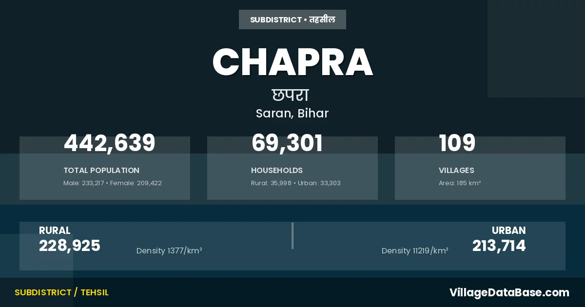
According to the 2011 census The total area of Chapra Subdivision is 185 km², with a population of 442639 people. The population density is 2,389 inhabitants per square kilometre, and there are approximately 69301 houses in the sub district.
Chapra Subdivision comprises about 109 villages. Below is a list of these villages along with information about their respective gram panchayats and the nearest town:
| # | Village Name | Gram Panchayat | Nearest Town |
|---|---|---|---|
| 1 | Amar Chhapra | Lohari | Chapra (10 km) |
| 2 | Badalpura | Maharajganj | Chapra (10 km) |
| 3 | Badalpura Diara | Maharajganj | Chapra |
| 4 | Badlutola | Badalu Tola | Chapra (10 km) |
| 5 | Bahoran Tola | Raipur Bingawan | Chapra (10 km) |
| 6 | Balgarha | Lohari | Chapra (20 km) |
| 7 | Balua | Musepur | Chapra |
| 8 | Banathi | Badalu Tola | Chapra (10 km) |
| 9 | Bangra | Badalu Tola | Chapra (10 km) |
| 10 | Barhampur | Chapra (10 km) | |
| 11 | Barhara Mahazi | Chapra (15 km) | |
| 12 | Basarhi | Purbari Telpa | Chapra (10 km) |
| 13 | Batani | Badalu Tola | Chapra (10 km) |
| 14 | Bazidpur | Naini | Chapra (12 km) |
| 15 | Bhairopur Aima | Bhairopur Nizamat | Chapra (10 km) |
| 16 | Bhairopur Nizamat | Bhairopur Nizamat | Chapra (10 km) |
| 17 | Bichla Telpa | Purbari Telpa | Chapra (5 km) |
| 18 | Bichli Badhar | Tenua | Chapra (10 km) |
| 19 | Bishunpura | Bishunpura | Chapra (10 km) |
| 20 | Chak Haji | Chirand | Chapra |
| 21 | Chak Jamali | Chirand | Chapra |
| 22 | Chakia | Bishunpura | Chapra (10 km) |
| 23 | Chan Chaura | Mauna | Chapra (10 km) |
| 24 | Chhuri Chhapra | Badalu Tola | Chapra (10 km) |
| 25 | Chirand | Chirand | Chapra (12 km) |
| 26 | Daftarpur | Bhairopur Nizamat | Chapra (10 km) |
| 27 | Dahiawan | Sarha | Chapra (5 km) |
| 28 | Dariyawganj | Maharajganj | Chapra (10 km) |
| 29 | Dhanpat Chhapra | Chapra (10 km) | |
| 30 | Dharampura | Chirand | Chapra (10 km) |
| 31 | Dhusaria | Chapra | |
| 32 | Diara Singahi | Chapra (20 km) | |
| 33 | Dumaria | Lohari | Chapra (10 km) |
| 34 | Dumri | Dumari | Chapra (10 km) |
| 35 | Ekauna | Chapra | |
| 36 | Gheghta | Sherpur Gheghata | Chapra (10 km) |
| 37 | Gopalpur | Bhairopur Nizamat | Chapra (10 km) |
| 38 | Harnarayan Chhapra | Badalu Tola | Chapra (10 km) |
| 39 | Hasanpurwa | Mauna | Chapra (5 km) |
| 40 | Ismailpur | Bhairopur Nizamat | Chapra (10 km) |
| 41 | Itahia | Badalu Tola | Chapra (10 km) |
| 42 | Jagdishpur | Jalalpur | Chapra (15 km) |
| 43 | Jalalpur | Jalalpur | Chapra (10 km) |
| 44 | Jamuna | Mauna | Chapra (10 km) |
| 45 | Jatia Bajidpur | Bhairopur Nizamat | Chapra (10 km) |
| 46 | Jatua | Phakuli | Chapra (5 km) |
| 47 | Kans Diar | Musepur | Chapra (10 km) |
| 48 | Karinga | Karinga | Chapra (5 km) |
| 49 | Khalpura Bala | Khalpura Bala | Chapra (10 km) |
| 50 | Khalpura Kamala | Chapra (10 km) | |
| 51 | Khawaspur | Bhairopur Nizamat | Chapra (10 km) |
| 52 | Khawaspur Khurd | Bhairopur Nizamat | Chapra (10 km) |
| 53 | Kotwapatti Rampur | Kotawa Patti Rampur | Chapra (15 km) |
| 54 | Lodipur | Maharajganj | Chapra (10 km) |
| 55 | Lodipur Diara | Maharajganj | Chapra |
| 56 | Lohra | Lohari | Chapra (10 km) |
| 57 | Lohri | Lohari | Chapra (10 km) |
| 58 | Madanipatti | Dumari | Chapra (10 km) |
| 59 | Mahaji Dharhara | Chapra | |
| 60 | Mahaji Khalpura Bala | Chapra | |
| 61 | Mahaji Khalpura Kamala | Kotawa Patti Rampur | Chapra |
| 62 | Maharajganj | Maharajganj | Chapra (10 km) |
| 63 | Makhdumganj | Khalpura Bala | Chapra (10 km) |
| 64 | Mala Mirja Tukra Ii | Chapra | |
| 65 | Malamirza Tukra | Purbari Telpa | Chapra (5 km) |
| 66 | Malasherpur | Chapra (10 km) | |
| 67 | Mangaidih | Karinga | Chapra (5 km) |
| 68 | Manupur Jahangir | Jalalpur | Chapra (10 km) |
| 69 | Manupur Manjhan | Jalalpur | Chapra (10 km) |
| 70 | Marahia | Badalu Tola | Chapra (10 km) |
| 71 | Mauna | Sherpur Gheghata | Chapra (5 km) |
| 72 | Mehian | Purbari Telpa | Chapra (5 km) |
| 73 | Mehrauli | Bhairopur Nizamat | Chapra (10 km) |
| 74 | Methwalia | Sarha | Chapra (5 km) |
| 75 | Mira Musehri | Tenua | Chapra (10 km) |
| 76 | Misraulia | Karinga | Chapra (5 km) |
| 77 | Mohaddipur | Bhairopur Nizamat | Chapra (10 km) |
| 78 | Musehri | Tenua | Chapra (5 km) |
| 79 | Musehri Mahto | Tenua | Chapra (10 km) |
| 80 | Musepur | Musepur | Chapra (10 km) |
| 81 | Naini | Naini | Chapra (10 km) |
| 82 | Nandlal Chhapra | Badalu Tola | Chapra (10 km) |
| 83 | Narayanpur | Chapra | |
| 84 | Nauadih | Khalpura Bala | Chapra (10 km) |
| 85 | Panapur | Maharajganj | Chapra (13 km) |
| 86 | Parsotim Chhapra | Chapra | |
| 87 | Phakuli | Phakuli | Chapra (10 km) |
| 88 | Phul Chak | Chirand | Chapra (10 km) |
| 89 | Purbari Telpa | Purbari Telpa | Chapra (5 km) |
| 90 | Qazipur | Jalalpur | Chapra (10 km) |
| 91 | Raipur Bingawan | Raipur Bingawan | Chapra (14 km) |
| 92 | Rajaiya Tola | Tenua | Chapra (10 km) |
| 93 | Ram Kolwa | Mauna | Chapra (10 km) |
| 94 | Rasalpura | Dumari | Chapra (10 km) |
| 95 | Ratanpura | Karinga | Chapra (5 km) |
| 96 | Sanrha | Sarha | Chapra |
| 97 | Semaria Mahazi | Barhara Mahaji | Chapra (15 km) |
| 98 | Shankarpur Urf Kutubpur | Kotawa Patti Rampur | Chapra |
| 99 | Sherpur | Sherpur Gheghata | Chapra (10 km) |
| 100 | Shukulpura | Kotawa Patti Rampur | Chapra (10 km) |
| 101 | Sidhwalia | Phakuli | Chapra (10 km) |
| 102 | Singahi | Dumari | Chapra (10 km) |
| 103 | Siram Chak | Karinga | Chapra |
| 104 | Sujan Chhapra | Badalu Tola | Chapra (10 km) |
| 105 | Taufir Maharajganj | Maharajganj | Chapra |
| 106 | Tejpurwa | Tenua | Chapra (10 km) |
| 107 | Tenua | Tenua | Chapra (10 km) |
| 108 | Todarpur | Kotawa Patti Rampur | Chapra |
| 109 | Turkaulia | Naini | Chapra (10 km) |
The population is distributed between urban and rural areas as follows:
| Particulars | Rural | Urban | Total |
|---|---|---|---|
| Total Population | 228925 | 213714 | 442639 |
| Male Population | 120698 | 112519 | 233217 |
| Female Population | 108227 | 101195 | 209422 | Population Density | 1377 / km² | 11219 / km² | 2,389 / km² |
The distribution of households in the Chapra is:
| Rural Households | Urban Households | Total Households |
|---|---|---|
| 35998 | 33303 | 69301 |
Q: What is Chapra?
A: Chapra is a town and in the Saran district of the Bihar.
Q: What is the total area of Chapra Subdivision?
A: The total area of Chapra Subdivision is 185 km².
Q: What is the population of Chapra Subdivision according to the 2011 census?
A: According to the 2011 census, the population of Chapra Subdivision is 442639.
Q: What is the population density of Chapra Subdivision?
A: The population density of Chapra Subdivision is 2,389 inhabitants per square kilometre.
Q: How many houses are there in Chapra Subdivision?
A: There are approximately 69301 houses in Chapra Subdivision.
Q: How many villages are there in Chapra Subdivision?
A: There are about 109 villages in Chapra Subdivision.
Q: Which is the largest village by population in Chapra Subdivision?
A: The largest village by population in Chapra Subdivision is Kotwapatti Rampur, with 11438 people.
Q: Which is the smallest village by population in Chapra Subdivision?
A: The smallest village by population in Chapra Subdivision is Badalpura Diara, with 0 people.
Q: Which is the largest village by area in Chapra Subdivision?
A: The largest village by area in Chapra Subdivision is Raipur Bingawan, with 1464 km².
Q: Which is the smallest village by area in Chapra Subdivision?
A: The smallest village by area in Chapra Subdivision is Mahaji Dharhara, with 0 km².
Q: What is the male population of Chapra Subdivision?
A: The male population of Chapra Subdivision is 233217.
Q: What is the female population of Chapra Subdivision?
A: The female population of Chapra Subdivision is 209422.
Q: How many villages in Chapra Subdivision have a population of less than 100?
A: There are 20 villages in Chapra Subdivision with a population of less than 100.
Q: How many villages in Chapra Subdivision have a population between 100 and 499?
A: There are 9 villages in Chapra Subdivision with a population between 100 and 499.
Q: How many villages in Chapra Subdivision have a population between 500 and 999?
A: There are 12 villages in Chapra Subdivision with a population between 500 and 999.
Q: How many villages in Chapra Subdivision have a population between 1000 and 1999?
A: There are 28 villages in Chapra Subdivision with a population between 1000 and 1999.
Q: How many villages in Chapra Subdivision have a population between 2000 and 2999?
A: There is 11 village in Chapra Subdivision with a population between 2000 and 2999.
Q: How many villages in Chapra Subdivision have a population between 3000 and 3999?
A: There is 13 village in Chapra Subdivision with a population between 3000 and 3999.
Q: How many villages in Chapra Subdivision have a population between 4000 and 4999?
A: There is 6 village in Chapra Subdivision with a population between 4000 and 4999.
Q: How many villages in Chapra Subdivision have a population of 5000 and above?
A: There is 10 village in Chapra Subdivision with a population of 5000 and above.
| Total Population | Villages in Sub District Of Chapra |
|---|---|
| Less than 100 | 20 |
| 100-499 | 9 |
| 500-999 | 12 |
| 1000-1999 | 28 |
| 2000-2999 | 11 |
| 3000-3999 | 13 |
| 4000-4999 | 6 |
| 5000 And Above | 10 |