Ishupur: A Town and Subdivision in Saran district
District → Saran
State → Bihar
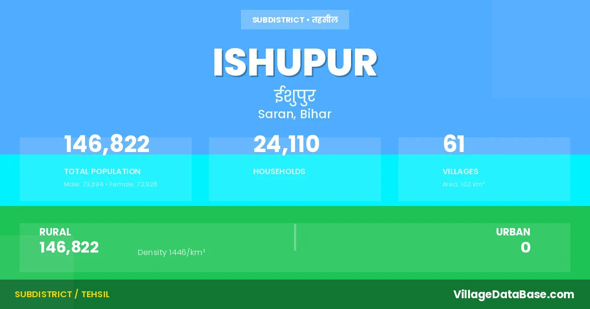
Ishupur is a town and Subdivision in the Saran district of the Bihar. In India, a Subdivision is a subdivision of a district responsible for the administration and revenue collection of a specific area within the district. Subdivisions play a crucial role in the local governance structure, contributing significantly to the development and administration of their communities.
According to the 2011 census The total area of Ishupur Subdivision is 102 km², with a population of 146822 people. The population density is 1,446 inhabitants per square kilometre, and there are approximately 24110 houses in the sub district.
Ishupur Subdivision comprises about 61 villages. Below is a list of these villages along with information about their respective gram panchayats and the nearest town:
| # | Village Name | Gram Panchayat | Nearest Town |
|---|---|---|---|
| 1 | Achitpur | Issuapur | Ishupur |
| 2 | Afzalpur | Agothar Sundar | Chapra (34 km) |
| 3 | Agauthar Nanda | Agothar Sundar | Chapra (33 km) |
| 4 | Agauthar Sundar | Agothar Sundar | Marhaura (7 km) |
| 5 | Amardah | Chakahan | Chapra (35 km) |
| 6 | Arazi Murwa | Lauwa | Chapra (33 km) |
| 7 | Atanagar | Ata Nagar | Chapra (33 km) |
| 8 | Bajrahia | Jaithar | Chapra (37 km) |
| 9 | Bangra | Ramchaura | Chapra (28 km) |
| 10 | Bhagwanpur | Datara Parsauli | Chapra (36 km) |
| 11 | Bishunpura | Ata Nagar | Chapra (33 km) |
| 12 | Chaharpura | Lauwa | Chapra (32 km) |
| 13 | Chakahan | Chakahan | Chapra (33 km) |
| 14 | Chanpurwa | Sahawa | Chapra (36 km) |
| 15 | Chhapia | Chhapia | Chapra (30 km) |
| 16 | Darwa | Datara Parsauli | Chapra (36 km) |
| 17 | Datra Pursauli | Datara Parsauli | Chapra (30 km) |
| 18 | Dhama | Kerawa | Chapra (35 km) |
| 19 | Doila | Rampur Atauli | Chapra (32 km) |
| 20 | Dumri | Chhapia | Chapra (33 km) |
| 21 | Galimapur | Jaithar | Chapra (37 km) |
| 22 | Gamharia | Lauwa | Chapra (32 km) |
| 23 | Gangoi | Ata Nagar | Chapra (35 km) |
| 24 | Gobinapur | Chakahan | Chapra (36 km) |
| 25 | Goha | Ata Nagar | Chapra (35 km) |
| 26 | Gunrajpur | Jaithar | Chapra (35 km) |
| 27 | Hankarpur | Lauwa | Chapra (32 km) |
| 28 | Isuwapur | Issuapur | Chapra (33 km) |
| 29 | Jaithar | Jaithar | Chapra (35 km) |
| 30 | Jerha | Nipaniya | Marhaura (3 km) |
| 31 | Kauria | Chakahan | Chapra (33 km) |
| 32 | Kerwa | Kerawa | Chapra (35 km) |
| 33 | Kumhaila | Rampur Atauli | Chapra (35 km) |
| 34 | Kusahar | Ata Nagar | Ishupur |
| 35 | Laua | Lauwa | Chapra (35 km) |
| 36 | Mahuli | Rampur Atauli | Chapra (34 km) |
| 37 | Man Pusauli | Issuapur | Chapra (32 km) |
| 38 | Marwa Khas | Lauwa | Chapra (33 km) |
| 39 | Mohuli | Agothar Sundar | Chapra (33 km) |
| 40 | Nagraj | Ata Nagar | Chapra (34 km) |
| 41 | Nawada | Sahawa | Chapra (30 km) |
| 42 | Nipanian | Nipaniya | Marhaura (5 km) |
| 43 | Parsa | Kerawa | Chapra (24 km) |
| 44 | Piarepur | Datara Parsauli | Chapra (36 km) |
| 45 | Piprahia | Ramchaura | Chapra (26 km) |
| 46 | Ramchaura | Ramchaura | Chapra (28 km) |
| 47 | Rampur Atauli | Rampur Atauli | Chapra (33 km) |
| 48 | Sahwa | Sahawa | Chapra (30 km) |
| 49 | Salempur | Nipaniya | Chapra (30 km) |
| 50 | Sanrhwara | Lauwa | Chapra (32 km) |
| 51 | Satasi | Ata Nagar | Chapra (35 km) |
| 52 | Shampur | Issuapur | Chapra (31 km) |
| 53 | Shampur Aima | Issuapur | Chapra (27 km) |
| 54 | Shampur Bealis | Issuapur | Chapra (32 km) |
| 55 | Shampur Israuli | Issuapur | Chapra (30 km) |
| 56 | Shiw Diari | Issuapur | Chapra (32 km) |
| 57 | Siswa | Chakahan | Chapra (30 km) |
| 58 | Sumbha | Issuapur | Chapra (28 km) |
| 59 | Usuri Kalan | Ramchaura | Chapra (27 km) |
| 60 | Usuri Kalan Tola Korar | Ramchaura | Chapra (26 km) |
| 61 | Usuri Khurd | Ramchaura | Chapra (27 km) |
The population is distributed between urban and rural areas as follows:
| Particulars | Rural | Urban | Total |
|---|---|---|---|
| Total Population | 146822 | 0 | 146822 |
| Male Population | 73894 | 0 | 73894 |
| Female Population | 72928 | 0 | 72928 | Population Density | 1446 / km² | 1,446 / km² |
The distribution of households in the Ishupur is:
| Rural Households | Urban Households | Total Households |
|---|---|---|
| 24110 | 0 | 24110 |
Q: What is Ishupur?
A: Ishupur is a town and in the Saran district of the Bihar.
Q: What is the total area of Ishupur Subdivision?
A: The total area of Ishupur Subdivision is 102 km².
Q: What is the population of Ishupur Subdivision according to the 2011 census?
A: According to the 2011 census, the population of Ishupur Subdivision is 146822.
Q: What is the population density of Ishupur Subdivision?
A: The population density of Ishupur Subdivision is 1,446 inhabitants per square kilometre.
Q: How many houses are there in Ishupur Subdivision?
A: There are approximately 24110 houses in Ishupur Subdivision.
Q: How many villages are there in Ishupur Subdivision?
A: There are about 61 villages in Ishupur Subdivision.
Q: Which is the largest village by population in Ishupur Subdivision?
A: The largest village by population in Ishupur Subdivision is Chhapia, with 13205 people.
Q: Which is the smallest village by population in Ishupur Subdivision?
A: The smallest village by population in Ishupur Subdivision is Achitpur, with 0 people.
Q: Which is the largest village by area in Ishupur Subdivision?
A: The largest village by area in Ishupur Subdivision is Chhapia, with 881 km².
Q: Which is the smallest village by area in Ishupur Subdivision?
A: The smallest village by area in Ishupur Subdivision is Achitpur, with 4 km².
Q: What is the population distribution between urban and rural areas in Ishupur Subdivision?
A: The population distribution in Ishupur Subdivision is entirely rural, with a total rural population of 146822.
Q: What is the male population of Ishupur Subdivision?
A: The male population of Ishupur Subdivision is 73894.
Q: What is the female population of Ishupur Subdivision?
A: The female population of Ishupur Subdivision is 72928.
Q: How is the household distribution in Ishupur Subdivision?
A: The household distribution in Ishupur Subdivision is entirely rural, with a total of 24110 households.
Q: How many villages in Ishupur Subdivision have a population of less than 100?
A: There are 2 villages in Ishupur Subdivision with a population of less than 100.
Q: How many villages in Ishupur Subdivision have a population between 100 and 499?
A: There are 7 villages in Ishupur Subdivision with a population between 100 and 499.
Q: How many villages in Ishupur Subdivision have a population between 500 and 999?
A: There are 6 villages in Ishupur Subdivision with a population between 500 and 999.
Q: How many villages in Ishupur Subdivision have a population between 1000 and 1999?
A: There are 16 villages in Ishupur Subdivision with a population between 1000 and 1999.
Q: How many villages in Ishupur Subdivision have a population between 2000 and 2999?
A: There is 12 village in Ishupur Subdivision with a population between 2000 and 2999.
Q: How many villages in Ishupur Subdivision have a population between 3000 and 3999?
A: There is 11 village in Ishupur Subdivision with a population between 3000 and 3999.
Q: How many villages in Ishupur Subdivision have a population between 4000 and 4999?
A: There is 4 village in Ishupur Subdivision with a population between 4000 and 4999.
Q: How many villages in Ishupur Subdivision have a population of 5000 and above?
A: There is 3 village in Ishupur Subdivision with a population of 5000 and above.
| Total Population | Villages in Sub District Of Ishupur |
|---|---|
| Less than 100 | 2 |
| 100-499 | 7 |
| 500-999 | 6 |
| 1000-1999 | 16 |
| 2000-2999 | 12 |
| 3000-3999 | 11 |
| 4000-4999 | 4 |
| 5000 And Above | 3 |