Mashrakh: A Town and Subdivision in Saran district
District → Saran
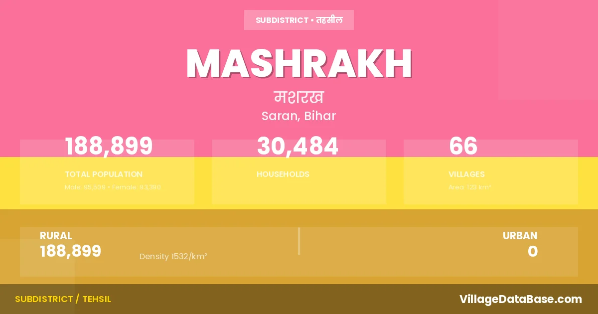
State → Bihar
Mashrakh is a town and Subdivision in the Saran district of the Bihar. In India, a Subdivision is a subdivision of a district responsible for the administration and revenue collection of a specific area within the district. Subdivisions play a crucial role in the local governance structure, contributing significantly to the development and administration of their communities.
According to the 2011 census The total area of Mashrakh Subdivision is 123 km², with a population of 188899 people. The population density is 1,532 inhabitants per square kilometre, and there are approximately 30484 houses in the sub district.
Mashrakh Subdivision comprises about 66 villages. Below is a list of these villages along with information about their respective gram panchayats and the nearest town:
| # | Village Name | Gram Panchayat | Nearest Town |
|---|---|---|---|
| 1 | Arna | Arana | Chapra (32 km) |
| 2 | Bahadurpur | Kawalpura | Chapra (45 km) |
| 3 | Bahiara | Nawada | Mashrakh |
| 4 | Bahrauli | Baharuli | Chapra (55 km) |
| 5 | Bahuara | Jajauli | Chapra (41 km) |
| 6 | Balua | Arana | Chapra (51 km) |
| 7 | Bangra | Bangra | Chapra (53 km) |
| 8 | Bansohi | Durgauli | Chapra (46 km) |
| 9 | Barahimpur Chakarpan | Nawada | Chapra (36 km) |
| 10 | Barahimpur Gopi | Nawada | Chapra (30 km) |
| 11 | Barwa Ghat | Durgauli | Chapra (48 km) |
| 12 | Bishunpura | Jajauli | Chapra (42 km) |
| 13 | Chainpur | Bangra | Chapra (40 km) |
| 14 | Chamaria | Sonauli | Chapra (42 km) |
| 15 | Chand Kudaria | Chand Kudariya | Chapra (56 km) |
| 16 | Charihara | Bangra | Chapra (36 km) |
| 17 | Chhapia | Arana | Chapra (46 km) |
| 18 | Dawangorhna | Semari | Chapra (39 km) |
| 19 | Deuria | Baharuli | Chapra (38 km) |
| 20 | Dhaurigopal | Kawalpura | Chapra (25 km) |
| 21 | Dumarsan | Dumarshan | Chapra (32 km) |
| 22 | Dumduma | Durgauli | Chapra (38 km) |
| 23 | Durgauli | Durgauli | Chapra (40 km) |
| 24 | Fardahia | Dumarshan | Chapra (44 km) |
| 25 | Gandaman | Jajauli | Chapra (39 km) |
| 26 | Gangauli | Gangauli | Chapra (40 km) |
| 27 | Ghogia | Gangauli | Chapra (50 km) |
| 28 | Gonauli | Kawalpura | Chapra (50 km) |
| 29 | Gorhna | Sonauli | Chapra (34 km) |
| 30 | Hansapir | Bangra | Chapra (39 km) |
| 31 | Hanuman Ganj | Mashrak | Chapra (30 km) |
| 32 | Harpur Jan | Chand Kudariya | Chapra (53 km) |
| 33 | Jajauli | Jajauli | Chapra (45 km) |
| 34 | Karan Kudaria | Karan Kudariya | Chapra (53 km) |
| 35 | Kawalpura | Kawalpura | Chapra (61 km) |
| 36 | Khairanpur | Gangauli | Chapra (44 km) |
| 37 | Khajuri | Kawalpura | Chapra (42 km) |
| 38 | Khap Sarsath | Bangra | Chapra (39 km) |
| 39 | Kishunpura | Kawalpura | Chapra (23 km) |
| 40 | Korranw | Nawada | Chapra (39 km) |
| 41 | Lakhanpur | Karan Kudariya | Chapra (50 km) |
| 42 | Madarpur | Kawalpura | Chapra (35 km) |
| 43 | Maguraha | Kawalpura | Chapra (40 km) |
| 44 | Mahesh Chhapra | Semari | Chapra (40 km) |
| 45 | Masrakh | Kawalpura | Chapra (41 km) |
| 46 | Mathia | Kawalpura | Chapra (24 km) |
| 47 | Narhar Barwa | Durgauli | Chapra (43 km) |
| 48 | Nawada | Nawada | Chapra (36 km) |
| 49 | Pachkhanda | Gangauli | Chapra (40 km) |
| 50 | Padmaul | Dumarshan | Chapra (51 km) |
| 51 | Padumpur | Dumarshan | Chapra (51 km) |
| 52 | Pakri | Kawalpura | Chapra (40 km) |
| 53 | Pilkhi | Nawada | Chapra (40 km) |
| 54 | Sankauli | Kawalpura | Chapra (40 km) |
| 55 | Sapahi | Arana | Chapra (50 km) |
| 56 | Semri | Semari | Chapra (40 km) |
| 57 | Serukaha | Kawalpura | Chapra (30 km) |
| 58 | Shamaspura | Semari | Chapra (34 km) |
| 59 | Sheikhpura | Baharuli | Chapra (50 km) |
| 60 | Sikti Bhikham | Semari | Chapra (40 km) |
| 61 | Sikti Khanjahan | Sonauli | Chapra (40 km) |
| 62 | Sirsa Jalalpur | Kawalpura | Chapra (44 km) |
| 63 | Sisai | Karan Kudariya | Chapra (58 km) |
| 64 | Siuri | Karan Kudariya | Chapra (50 km) |
| 65 | Sonauli | Sonauli | Chapra (40 km) |
| 66 | Sundar | Chand Kudariya | Chapra (50 km) |
The population is distributed between urban and rural areas as follows:
| Particulars | Rural | Urban | Total |
|---|---|---|---|
| Total Population | 188899 | 0 | 188899 |
| Male Population | 95509 | 0 | 95509 |
| Female Population | 93390 | 0 | 93390 | Population Density | 1532 / km² | 1,532 / km² |
The distribution of households in the Mashrakh is:
| Rural Households | Urban Households | Total Households |
|---|---|---|
| 30484 | 0 | 30484 |
Q: What is Mashrakh?
A: Mashrakh is a town and in the Saran district of the Bihar.
Q: What is the total area of Mashrakh Subdivision?
A: The total area of Mashrakh Subdivision is 123 km².
Q: What is the population of Mashrakh Subdivision according to the 2011 census?
A: According to the 2011 census, the population of Mashrakh Subdivision is 188899.
Q: What is the population density of Mashrakh Subdivision?
A: The population density of Mashrakh Subdivision is 1,532 inhabitants per square kilometre.
Q: How many houses are there in Mashrakh Subdivision?
A: There are approximately 30484 houses in Mashrakh Subdivision.
Q: How many villages are there in Mashrakh Subdivision?
A: There are about 66 villages in Mashrakh Subdivision.
Q: Which is the largest village by population in Mashrakh Subdivision?
A: The largest village by population in Mashrakh Subdivision is Masrakh, with 24197 people.
Q: Which is the smallest village by population in Mashrakh Subdivision?
A: The smallest village by population in Mashrakh Subdivision is Bahiara, with 0 people.
Q: Which is the largest village by area in Mashrakh Subdivision?
A: The largest village by area in Mashrakh Subdivision is Masrakh, with 1257 km².
Q: Which is the smallest village by area in Mashrakh Subdivision?
A: The smallest village by area in Mashrakh Subdivision is Khap Sarsath, with 23 km².
Q: What is the population distribution between urban and rural areas in Mashrakh Subdivision?
A: The population distribution in Mashrakh Subdivision is entirely rural, with a total rural population of 188899.
Q: What is the male population of Mashrakh Subdivision?
A: The male population of Mashrakh Subdivision is 95509.
Q: What is the female population of Mashrakh Subdivision?
A: The female population of Mashrakh Subdivision is 93390.
Q: How is the household distribution in Mashrakh Subdivision?
A: The household distribution in Mashrakh Subdivision is entirely rural, with a total of 30484 households.
Q: How many villages in Mashrakh Subdivision have a population of less than 100?
A: There are 2 villages in Mashrakh Subdivision with a population of less than 100.
Q: How many villages in Mashrakh Subdivision have a population between 100 and 499?
A: There are 2 villages in Mashrakh Subdivision with a population between 100 and 499.
Q: How many villages in Mashrakh Subdivision have a population between 500 and 999?
A: There are 6 villages in Mashrakh Subdivision with a population between 500 and 999.
Q: How many villages in Mashrakh Subdivision have a population between 1000 and 1999?
A: There are 18 villages in Mashrakh Subdivision with a population between 1000 and 1999.
Q: How many villages in Mashrakh Subdivision have a population between 2000 and 2999?
A: There is 21 village in Mashrakh Subdivision with a population between 2000 and 2999.
Q: How many villages in Mashrakh Subdivision have a population between 3000 and 3999?
A: There is 8 village in Mashrakh Subdivision with a population between 3000 and 3999.
Q: How many villages in Mashrakh Subdivision have a population between 4000 and 4999?
A: There is 2 village in Mashrakh Subdivision with a population between 4000 and 4999.
Q: How many villages in Mashrakh Subdivision have a population of 5000 and above?
A: There is 7 village in Mashrakh Subdivision with a population of 5000 and above.
| Total Population | Villages in Sub District Of Mashrakh |
|---|---|
| Less than 100 | 2 |
| 100-499 | 2 |
| 500-999 | 6 |
| 1000-1999 | 18 |
| 2000-2999 | 21 |
| 3000-3999 | 8 |
| 4000-4999 | 2 |
| 5000 And Above | 7 |