District → Saran
State → Bihar
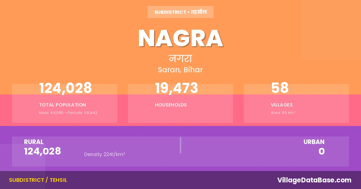
Nagra is a town and Subdivision in the Saran district of the Bihar. In India, a Subdivision is a subdivision of a district responsible for the administration and revenue collection of a specific area within the district. Subdivisions play a crucial role in the local governance structure, contributing significantly to the development and administration of their communities.
According to the 2011 census The total area of Nagra Subdivision is 55 km², with a population of 124028 people. The population density is 2,241 inhabitants per square kilometre, and there are approximately 19473 houses in the sub district.
Nagra Subdivision comprises about 58 villages. Below is a list of these villages along with information about their respective gram panchayats and the nearest town:
| # | Village Name | Gram Panchayat | Nearest Town |
|---|---|---|---|
| 1 | Aphaur | Aphaur | Chapra (10 km) |
| 2 | Arwa | Nagra | Chapra (10 km) |
| 3 | Bagahi | Dhupnagar Dhobwal | Chapra (30 km) |
| 4 | Baldiha | Jagadishpur | Chapra (10 km) |
| 5 | Bangra | Kadipur | Chapra (10 km) |
| 6 | Banni | Kadipur | Chapra (10 km) |
| 7 | Banri Dhobwal | Dhupnagar Dhobwal | Chapra (10 km) |
| 8 | Baranpura | Dhupnagar Dhobwal | Chapra (10 km) |
| 9 | Bhikhampur | Tujar Pur | Chapra (10 km) |
| 10 | Chainpur | Kadipur | Chapra (10 km) |
| 11 | Chak Asraf | Korea | Chapra (10 km) |
| 12 | Chak Makho | Korea | Chapra (10 km) |
| 13 | Chandanpur | Korea | Chapra (10 km) |
| 14 | Chhitrauli | Dhupnagar Dhobwal | Chapra (12 km) |
| 15 | Damri Tola | Khaira | Chapra (10 km) |
| 16 | Dharampur | Korea | Chapra (10 km) |
| 17 | Dhupnagar Dhobwal | Dhupnagar Dhobwal | Chapra (10 km) |
| 18 | Dumri | Dumari | Chapra (13 km) |
| 19 | Faradpura | Chapra (10 km) | |
| 20 | Gobindpur | Dumari | Chapra (10 km) |
| 21 | Gopalpur | Dumari | Chapra (10 km) |
| 22 | Hardi Chhapra | Khaira | Chapra (13 km) |
| 23 | Hariharpur | Dumari | Chapra (12 km) |
| 24 | Hariram Ka Tola | Khaira | Chapra (10 km) |
| 25 | Husenpur | Korea | Chapra (10 km) |
| 26 | Jagdishpur | Jagadishpur | Chapra (10 km) |
| 27 | Jahanpur | Korea | Chapra (10 km) |
| 28 | Kadipur | Kadipur | Chapra (10 km) |
| 29 | Kakarhia | Korea | Chapra (10 km) |
| 30 | Kalupur | Tujar Pur | Chapra (10 km) |
| 31 | Kanar | Dumari | Chapra (13 km) |
| 32 | Katesar Buzurg | Korea | Chapra (20 km) |
| 33 | Khaira | Khaira | Chapra (10 km) |
| 34 | Khaje Sarae | Takia | Chapra (10 km) |
| 35 | Khanpur | Khaira | Chapra (10 km) |
| 36 | Korea | Korea | Chapra (10 km) |
| 37 | Loha Chhapra | Korea | Chapra (10 km) |
| 38 | Madaria | Chapra (10 km) | |
| 39 | Mahammanpatti | Tujar Pur | Chapra (10 km) |
| 40 | Maksuspur | Takia | Chapra (10 km) |
| 41 | Manpur | Dumari | Chapra (10 km) |
| 42 | Masihah Tola | Korea | Chapra (20 km) |
| 43 | Murar Chhapra | Dhupnagar Dhobwal | Chapra (10 km) |
| 44 | Nagra | Korea | Chapra (10 km) |
| 45 | Nempuri Ke Tola | Khaira | Chapra (10 km) |
| 46 | Paharpur | Jagadishpur | Chapra (10 km) |
| 47 | Paterha | Tujar Pur | Chapra (10 km) |
| 48 | Raghunathpur | Dhupnagar Dhobwal | Chapra (10 km) |
| 49 | Rampur | Khaira | Chapra (10 km) |
| 50 | Rasulpur | Korea | Chapra (10 km) |
| 51 | Sahimpur | Dumari | Chapra (10 km) |
| 52 | Saidupur | Aphaur | Chapra (10 km) |
| 53 | Sargatti | Jagadishpur | Chapra (10 km) |
| 54 | Shahpur | Jagadishpur | Chapra (10 km) |
| 55 | Takia | Korea | Chapra (10 km) |
| 56 | Tetarpur | Jagadishpur | Chapra (17 km) |
| 57 | Tola Parwezkhan | Dumari | Chapra (10 km) |
| 58 | Tujarpur | Tujar Pur | Chapra (10 km) |
The population is distributed between urban and rural areas as follows:
| Particulars | Rural | Urban | Total |
|---|---|---|---|
| Total Population | 124028 | 0 | 124028 |
| Male Population | 64086 | 0 | 64086 |
| Female Population | 59942 | 0 | 59942 | Population Density | 2241 / km² | 2,241 / km² |
The distribution of households in the Nagra is:
| Rural Households | Urban Households | Total Households |
|---|---|---|
| 19473 | 0 | 19473 |
Q: What is Nagra?
A: Nagra is a town and in the Saran district of the Bihar.
Q: What is the total area of Nagra Subdivision?
A: The total area of Nagra Subdivision is 55 km².
Q: What is the population of Nagra Subdivision according to the 2011 census?
A: According to the 2011 census, the population of Nagra Subdivision is 124028.
Q: What is the population density of Nagra Subdivision?
A: The population density of Nagra Subdivision is 2,241 inhabitants per square kilometre.
Q: How many houses are there in Nagra Subdivision?
A: There are approximately 19473 houses in Nagra Subdivision.
Q: How many villages are there in Nagra Subdivision?
A: There are about 58 villages in Nagra Subdivision.
Q: Which is the largest village by population in Nagra Subdivision?
A: The largest village by population in Nagra Subdivision is Aphaur, with 11294 people.
Q: Which is the smallest village by population in Nagra Subdivision?
A: The smallest village by population in Nagra Subdivision is Damri Tola, with 107 people.
Q: Which is the largest village by area in Nagra Subdivision?
A: The largest village by area in Nagra Subdivision is Aphaur, with 492 km².
Q: Which is the smallest village by area in Nagra Subdivision?
A: The smallest village by area in Nagra Subdivision is Damri Tola, with 10 km².
Q: What is the population distribution between urban and rural areas in Nagra Subdivision?
A: The population distribution in Nagra Subdivision is entirely rural, with a total rural population of 124028.
Q: What is the male population of Nagra Subdivision?
A: The male population of Nagra Subdivision is 64086.
Q: What is the female population of Nagra Subdivision?
A: The female population of Nagra Subdivision is 59942.
Q: How is the household distribution in Nagra Subdivision?
A: The household distribution in Nagra Subdivision is entirely rural, with a total of 19473 households.
Q: How many villages in Nagra Subdivision have a population between 100 and 499?
A: There are 9 villages in Nagra Subdivision with a population between 100 and 499.
Q: How many villages in Nagra Subdivision have a population between 500 and 999?
A: There are 12 villages in Nagra Subdivision with a population between 500 and 999.
Q: How many villages in Nagra Subdivision have a population between 1000 and 1999?
A: There are 13 villages in Nagra Subdivision with a population between 1000 and 1999.
Q: How many villages in Nagra Subdivision have a population between 2000 and 2999?
A: There is 11 village in Nagra Subdivision with a population between 2000 and 2999.
Q: How many villages in Nagra Subdivision have a population between 3000 and 3999?
A: There is 4 village in Nagra Subdivision with a population between 3000 and 3999.
Q: How many villages in Nagra Subdivision have a population between 4000 and 4999?
A: There is 4 village in Nagra Subdivision with a population between 4000 and 4999.
Q: How many villages in Nagra Subdivision have a population of 5000 and above?
A: There is 5 village in Nagra Subdivision with a population of 5000 and above.
| Total Population | Villages in Sub District Of Nagra |
|---|---|
| 100-499 | 9 |
| 500-999 | 12 |
| 1000-1999 | 13 |
| 2000-2999 | 11 |
| 3000-3999 | 4 |
| 4000-4999 | 4 |
| 5000 And Above | 5 |