Panapur: A Town and Subdivision in Saran district
District → Saran
State → Bihar
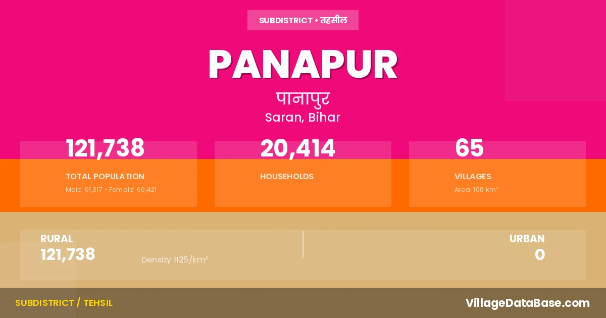
Panapur is a town and Subdivision in the Saran district of the Bihar. In India, a Subdivision is a subdivision of a district responsible for the administration and revenue collection of a specific area within the district. Subdivisions play a crucial role in the local governance structure, contributing significantly to the development and administration of their communities.
According to the 2011 census The total area of Panapur Subdivision is 108 km², with a population of 121738 people. The population density is 1,125 inhabitants per square kilometre, and there are approximately 20414 houses in the sub district.
Panapur Subdivision comprises about 65 villages. Below is a list of these villages along with information about their respective gram panchayats and the nearest town:
| # | Village Name | Gram Panchayat | Nearest Town |
|---|---|---|---|
| 1 | Arazi Naubarar | Panapur | |
| 2 | Bagdiha | Satjora | Chapra (27 km) |
| 3 | Bairagi Bhuin | Chapra (45 km) | |
| 4 | Bakwa | Bakwa | Chapra (40 km) |
| 5 | Basahiya | Basahiya | Chapra (45 km) |
| 6 | Basatpur | Basahiya | Chapra (28 km) |
| 7 | Belaur | Chapra (32 km) | |
| 8 | Betaura | Satjora | Chapra (35 km) |
| 9 | Bhagwanpur | Chakiya | Chapra (34 km) |
| 10 | Bhagwanpur Birt | Basahiya | Chapra (36 km) |
| 11 | Bhagwanpur Dhab | Basahiya | Panapur |
| 12 | Bhoraha | Bhoraha | Chapra (40 km) |
| 13 | Bijauli | Totaha Jagatpur | Chapra (25 km) |
| 14 | Chak Ramdaspur | Bhoraha | Chapra (30 km) |
| 15 | Chakia | Chakiya | Chapra (34 km) |
| 16 | Chausa | Totaha Jagatpur | Chapra (55 km) |
| 17 | Chimanpura | Totaha Jagatpur | Chapra (40 km) |
| 18 | Chintamanpur | Chakiya | Chapra (34 km) |
| 19 | Dhanauti | Bakwa | Chapra (30 km) |
| 20 | Dhenuki | Dhenuki | Chapra (30 km) |
| 21 | Dhobwal | Mahmad Pur | Chapra (42 km) |
| 22 | Dubauli | Dhenuki | Chapra (45 km) |
| 23 | Fatehpur | Basahiya | Chapra (33 km) |
| 24 | Harakhpakri | Satjora | Chapra (27 km) |
| 25 | Jipura | Bhoraha | Chapra (30 km) |
| 26 | Karchulia | Chakiya | Chapra (35 km) |
| 27 | Khajuri | Chakiya | Chapra (37 km) |
| 28 | Khapkat Bhagwanpur | Chakiya | Panapur |
| 29 | Khardewa | Mahmad Pur | Chapra (30 km) |
| 30 | Kondh | Kondha | Chapra (30 km) |
| 31 | Laguni | Dhenuki | Chapra (40 km) |
| 32 | Mahammadpur | Mahmad Pur | Chapra (40 km) |
| 33 | Maria | Bhoraha | Chapra (19 km) |
| 34 | Mathaura | Totaha Jagatpur | Chapra (10 km) |
| 35 | Moria | Bhoraha | Chapra (40 km) |
| 36 | Murli Math | Chapra (45 km) | |
| 37 | Murwa | Mahmad Pur | Chapra (30 km) |
| 38 | Murwa Basahia | Basahiya | Chapra (45 km) |
| 39 | Pakrinarotim | Totaha Jagatpur | Chapra (55 km) |
| 40 | Panapur | Bakwa | Chapra (30 km) |
| 41 | Pawari Patti Moria | Bhoraha | Chapra (17 km) |
| 42 | Phakuli | Mahmad Pur | Chapra (45 km) |
| 43 | Pipra | Chapra (28 km) | |
| 44 | Pipra Singahi | Satjora | Chapra (52 km) |
| 45 | Pirthamipur | Chakiya | Chapra (36 km) |
| 46 | Ramdaspur | Bhoraha | Chapra (30 km) |
| 47 | Rampur Kharauni | Bhoraha | Chapra (40 km) |
| 48 | Rampur Rudar | Kondha | Chapra (30 km) |
| 49 | Rasauli | Rasauli | Chapra (30 km) |
| 50 | Salempur | Basahiya | Chapra (20 km) |
| 51 | Sani Ramdaspur | Bhoraha | Chapra (19 km) |
| 52 | Sarangpur | Panapur | |
| 53 | Saraunja | Panapur | |
| 54 | Satjora | Satjora | Chapra (35 km) |
| 55 | Semraha | Chapra (50 km) | |
| 56 | Semri | Belor | Chapra (15 km) |
| 57 | Shahbazpur | Totaha Jagatpur | Chapra (49 km) |
| 58 | Singahi | Panapur | |
| 59 | Sonbarsa | Basahiya | Chapra (45 km) |
| 60 | Tola Totaha | Totaha Jagatpur | Panapur |
| 61 | Totaha | Totaha Jagatpur | Chapra (35 km) |
| 62 | Totaha Jagatpur | Totaha Jagatpur | Chapra (24 km) |
| 63 | Turki | Mahmad Pur | Chapra (25 km) |
| 64 | Ubhbwa | Kondha | Chapra (30 km) |
| 65 | Ubhbwa Saraynja | Kondha | Chapra (30 km) |
The population is distributed between urban and rural areas as follows:
| Particulars | Rural | Urban | Total |
|---|---|---|---|
| Total Population | 121738 | 0 | 121738 |
| Male Population | 61317 | 0 | 61317 |
| Female Population | 60421 | 0 | 60421 | Population Density | 1125 / km² | 1,125 / km² |
The distribution of households in the Panapur is:
| Rural Households | Urban Households | Total Households |
|---|---|---|
| 20414 | 0 | 20414 |
Q: What is Panapur?
A: Panapur is a town and in the Saran district of the Bihar.
Q: What is the total area of Panapur Subdivision?
A: The total area of Panapur Subdivision is 108 km².
Q: What is the population of Panapur Subdivision according to the 2011 census?
A: According to the 2011 census, the population of Panapur Subdivision is 121738.
Q: What is the population density of Panapur Subdivision?
A: The population density of Panapur Subdivision is 1,125 inhabitants per square kilometre.
Q: How many houses are there in Panapur Subdivision?
A: There are approximately 20414 houses in Panapur Subdivision.
Q: How many villages are there in Panapur Subdivision?
A: There are about 65 villages in Panapur Subdivision.
Q: Which is the largest village by population in Panapur Subdivision?
A: The largest village by population in Panapur Subdivision is Rasauli, with 11332 people.
Q: Which is the smallest village by population in Panapur Subdivision?
A: The smallest village by population in Panapur Subdivision is Arazi Naubarar, with 0 people.
Q: Which is the largest village by area in Panapur Subdivision?
A: The largest village by area in Panapur Subdivision is Rasauli, with 952 km².
Q: Which is the smallest village by area in Panapur Subdivision?
A: The smallest village by area in Panapur Subdivision is Khapkat Bhagwanpur, with 6 km².
Q: What is the population distribution between urban and rural areas in Panapur Subdivision?
A: The population distribution in Panapur Subdivision is entirely rural, with a total rural population of 121738.
Q: What is the male population of Panapur Subdivision?
A: The male population of Panapur Subdivision is 61317.
Q: What is the female population of Panapur Subdivision?
A: The female population of Panapur Subdivision is 60421.
Q: How is the household distribution in Panapur Subdivision?
A: The household distribution in Panapur Subdivision is entirely rural, with a total of 20414 households.
Q: How many villages in Panapur Subdivision have a population of less than 100?
A: There are 8 villages in Panapur Subdivision with a population of less than 100.
Q: How many villages in Panapur Subdivision have a population between 100 and 499?
A: There are 8 villages in Panapur Subdivision with a population between 100 and 499.
Q: How many villages in Panapur Subdivision have a population between 500 and 999?
A: There are 9 villages in Panapur Subdivision with a population between 500 and 999.
Q: How many villages in Panapur Subdivision have a population between 1000 and 1999?
A: There are 20 villages in Panapur Subdivision with a population between 1000 and 1999.
Q: How many villages in Panapur Subdivision have a population between 2000 and 2999?
A: There is 9 village in Panapur Subdivision with a population between 2000 and 2999.
Q: How many villages in Panapur Subdivision have a population between 3000 and 3999?
A: There is 6 village in Panapur Subdivision with a population between 3000 and 3999.
Q: How many villages in Panapur Subdivision have a population between 4000 and 4999?
A: There is 2 village in Panapur Subdivision with a population between 4000 and 4999.
Q: How many villages in Panapur Subdivision have a population of 5000 and above?
A: There is 3 village in Panapur Subdivision with a population of 5000 and above.
| Total Population | Villages in Sub District Of Panapur |
|---|---|
| Less than 100 | 8 |
| 100-499 | 8 |
| 500-999 | 9 |
| 1000-1999 | 20 |
| 2000-2999 | 9 |
| 3000-3999 | 6 |
| 4000-4999 | 2 |
| 5000 And Above | 3 |