Majorganj: A Town and Subdivision in Sitamarhi district
District → Sitamarhi
State → Bihar
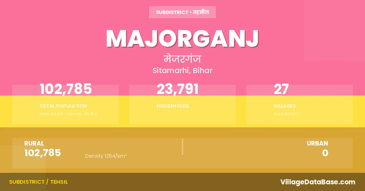
Majorganj is a town and Subdivision in the Sitamarhi district of the Bihar. In India, a Subdivision is a subdivision of a district responsible for the administration and revenue collection of a specific area within the district. Subdivisions play a crucial role in the local governance structure, contributing significantly to the development and administration of their communities.
According to the 2011 census The total area of Majorganj Subdivision is 82 km², with a population of 102785 people. The population density is 1,254 inhabitants per square kilometre, and there are approximately 23791 houses in the sub district.
Majorganj Subdivision comprises about 27 villages. Below is a list of these villages along with information about their respective gram panchayats and the nearest town:
| # | Village Name | Gram Panchayat | Nearest Town |
|---|---|---|---|
| 1 | Akhardiha | Kuari Madan | Sitamarhi (25 km) |
| 2 | Bahera | Bahera | Sitamarhi (29 km) |
| 3 | Barahi Hari Ram | Khairwa | Sitamarhi (30 km) |
| 4 | Bariarpur | Ratanpur | Sitamarhi (26 km) |
| 5 | Basbita | Basabitta | Sitamarhi (28 km) |
| 6 | Belwa Parri | Pachaharwa | Sitamarhi (45 km) |
| 7 | Bhilwahi | Pachaharwa | Sitamarhi (40 km) |
| 8 | Bhokraha | Ratanpur | Sitamarhi (25 km) |
| 9 | Bisambharpur Nankar | Bahera | Sitamarhi (30 km) |
| 10 | Dumri Kalan Urf Madhuban Jadu | Dumari Kala | Sitamarhi (36 km) |
| 11 | Dumri Khurd | Dumari Kala | Sitamarhi (30 km) |
| 12 | Garhwa Bishunpur | Pachaharwa | Sitamarhi (35 km) |
| 13 | Halimpur | Dumari Kala | Sltamarhi (30 km) |
| 14 | Hanumannagar | Pachaharwa | Sitamarhi (35 km) |
| 15 | Harpur Kalan | Ratanpur | Sitamarhi (25 km) |
| 16 | Hinrolwa Bishunpur Parsotim | Kuari Madan | Sitamarhi (25 km) |
| 17 | Khairwa | Khairwa | Sitamarhi (25 km) |
| 18 | Kuari Madan | Kuari Madan | Sitamarhi (25 km) |
| 19 | Madhopur Malinia | Bahera | Sitamarhi (29 km) |
| 20 | Marpa Sirpal | Pachaharwa | Sitamarhi (42 km) |
| 21 | Mejar Ganj Malahi | Majorganj | Sitamarhi (25 km) |
| 22 | Pachharwa | Pachaharwa | Sitamarhi (45 km) |
| 23 | Raghunathpur | Basabitta | Sitamarhi (28 km) |
| 24 | Rampat Pakri | Kuari Madan | Sitamarhi (45 km) |
| 25 | Rasulpur Pitaunjia | Basabitta | Sitamarhi (28 km) |
| 26 | Ratanpur | Ratanpur | Sitamadhi (25 km) |
| 27 | Sonaul Mahodat | Kuari Madan | Sitamarhi (25 km) |
The population is distributed between urban and rural areas as follows:
| Particulars | Rural | Urban | Total |
|---|---|---|---|
| Total Population | 102785 | 0 | 102785 |
| Male Population | 54031 | 0 | 54031 |
| Female Population | 48754 | 0 | 48754 | Population Density | 1254 / km² | 1,254 / km² |
The distribution of households in the Majorganj is:
| Rural Households | Urban Households | Total Households |
|---|---|---|
| 23791 | 0 | 23791 |
Q: What is Majorganj?
A: Majorganj is a town and in the Sitamarhi district of the Bihar.
Q: What is the total area of Majorganj Subdivision?
A: The total area of Majorganj Subdivision is 82 km².
Q: What is the population of Majorganj Subdivision according to the 2011 census?
A: According to the 2011 census, the population of Majorganj Subdivision is 102785.
Q: What is the population density of Majorganj Subdivision?
A: The population density of Majorganj Subdivision is 1,254 inhabitants per square kilometre.
Q: How many houses are there in Majorganj Subdivision?
A: There are approximately 23791 houses in Majorganj Subdivision.
Q: How many villages are there in Majorganj Subdivision?
A: There are about 27 villages in Majorganj Subdivision.
Q: Which is the largest village by population in Majorganj Subdivision?
A: The largest village by population in Majorganj Subdivision is Mejar Ganj Malahi, with 11024 people.
Q: Which is the smallest village by population in Majorganj Subdivision?
A: The smallest village by population in Majorganj Subdivision is Rampat Pakri, with 527 people.
Q: Which is the largest village by area in Majorganj Subdivision?
A: The largest village by area in Majorganj Subdivision is Dumri Kalan Urf Madhuban Jadu, with 1107 km².
Q: Which is the smallest village by area in Majorganj Subdivision?
A: The smallest village by area in Majorganj Subdivision is Hanumannagar, with 47 km².
Q: What is the population distribution between urban and rural areas in Majorganj Subdivision?
A: The population distribution in Majorganj Subdivision is entirely rural, with a total rural population of 102785.
Q: What is the male population of Majorganj Subdivision?
A: The male population of Majorganj Subdivision is 54031.
Q: What is the female population of Majorganj Subdivision?
A: The female population of Majorganj Subdivision is 48754.
Q: How is the household distribution in Majorganj Subdivision?
A: The household distribution in Majorganj Subdivision is entirely rural, with a total of 23791 households.
Q: How many villages in Majorganj Subdivision have a population between 500 and 999?
A: There are 2 villages in Majorganj Subdivision with a population between 500 and 999.
Q: How many villages in Majorganj Subdivision have a population between 1000 and 1999?
A: There are 2 villages in Majorganj Subdivision with a population between 1000 and 1999.
Q: How many villages in Majorganj Subdivision have a population between 2000 and 2999?
A: There is 6 village in Majorganj Subdivision with a population between 2000 and 2999.
Q: How many villages in Majorganj Subdivision have a population between 3000 and 3999?
A: There is 10 village in Majorganj Subdivision with a population between 3000 and 3999.
Q: How many villages in Majorganj Subdivision have a population between 4000 and 4999?
A: There is 2 village in Majorganj Subdivision with a population between 4000 and 4999.
Q: How many villages in Majorganj Subdivision have a population of 5000 and above?
A: There is 5 village in Majorganj Subdivision with a population of 5000 and above.
| Total Population | Villages in Sub District Of Majorganj |
|---|---|
| 500-999 | 2 |
| 1000-1999 | 2 |
| 2000-2999 | 6 |
| 3000-3999 | 10 |
| 4000-4999 | 2 |
| 5000 And Above | 5 |