Sursand: A Town and Subdivision in Sitamarhi district
District → Sitamarhi
State → Bihar
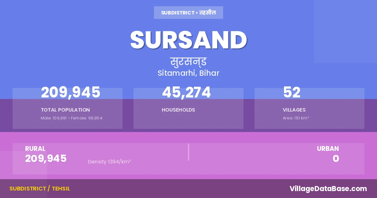
Sursand is a town and Subdivision in the Sitamarhi district of the Bihar. In India, a Subdivision is a subdivision of a district responsible for the administration and revenue collection of a specific area within the district. Subdivisions play a crucial role in the local governance structure, contributing significantly to the development and administration of their communities.
According to the 2011 census The total area of Sursand Subdivision is 151 km², with a population of 209945 people. The population density is 1,394 inhabitants per square kilometre, and there are approximately 45274 houses in the sub district.
Sursand Subdivision comprises about 52 villages. Below is a list of these villages along with information about their respective gram panchayats and the nearest town:
| # | Village Name | Gram Panchayat | Nearest Town |
|---|---|---|---|
| 1 | Adalpur | Pathanpura | Sitamarhi (35 km) |
| 2 | Amana | Amana | Sitamarhi (35 km) |
| 3 | Az Rakbe Piprarhi | Kadarwana | Sitamarhi (20 km) |
| 4 | Baghari | Baghadi | Sitamarhi (30 km) |
| 5 | Bakhari | Kumma | Sitamarhi (16 km) |
| 6 | Banauli | Banauli | Sitamarhi (35 km) |
| 7 | Bara | Baghadi | Sitamarhi (20 km) |
| 8 | Belahia | Kumma | Sitamarhi (20 km) |
| 9 | Bhamua | Koriyahi | Sitamarhi (40 km) |
| 10 | Bhilwahi | Koriyahi | Sitamarhi (21 km) |
| 11 | Bindi Nowabad | Koriyahi | Sitamarhi (40 km) |
| 12 | Birpur | Malahi | Sitamarhi (25 km) |
| 13 | Birrakh | Birrakh | Sitamarhi (30 km) |
| 14 | Chakni | Diwari Matauna | Sitamarhi (36 km) |
| 15 | Chandpatti | Banauli | Sitamarhi (25 km) |
| 16 | Darha Bari | Dadhawari | Sitamarhi (35 km) |
| 17 | Deonathpatti | Amana | Sitamarhi (35 km) |
| 18 | Dewari Matauna | Diwari Matauna | Sitamarhi (35 km) |
| 19 | Dhanarhi | Baghadi | Sitamarhi (25 km) |
| 20 | Gopalpur | Sursand Purvi | Sitamarhi (0 km) |
| 21 | Harari Dularpur | Banauli | Sitamarhi (22 km) |
| 22 | Jawahirpur | Amana | Sitamarhi (35 km) |
| 23 | Kabira | Amana | Sitamarhi (35 km) |
| 24 | Kansara | Kumma | Sitamarhi (18 km) |
| 25 | Kararbana | Kadarwana | Sitamarhi (18 km) |
| 26 | Kaurna | Malahi | Sitamarhi (35 km) |
| 27 | Koriahi Urf Kalyanpatti | Koriyahi | Sitamarhi (35 km) |
| 28 | Kuari | Baghadi | Sitamarhi (25 km) |
| 29 | Kumma | Kumma | Sitamarhi (16 km) |
| 30 | Majhaulia | Maruki | Sitamarhi (15 km) |
| 31 | Majhaura | Amana | Sitamarhi (35 km) |
| 32 | Makunahia | Radhaur | Sitamarhi (26 km) |
| 33 | Malahi | Malahi | Sitamarhi (30 km) |
| 34 | Maruki | Maruki | Sitamarhi (15 km) |
| 35 | Meghpur | Dadhawari | Sitamarhi (40 km) |
| 36 | Murlia Chak Urf Majhaulia | Maruki | Sursand |
| 37 | Parri | Amana | Sitamarhi (42 km) |
| 38 | Parsa Urf Parsad | Maruki | Sitamarhi (20 km) |
| 39 | Pathanpur | Pathanpura | Sitamarhi (30 km) |
| 40 | Pikdharpur | Radhaur | Sitamarhi (30 km) |
| 41 | Piprarhi | Kadarwana | Sitamarhi (10 km) |
| 42 | Radhau | Radhaur | Sitamarhi (25 km) |
| 43 | Raghunipatti | Kadarwana | Sitamarhi (20 km) |
| 44 | Reghaipur | Pathanpura | Sitamarhi (30 km) |
| 45 | Samhua | Koriyahi | Sitamarhi (45 km) |
| 46 | Sarkhandio Bitha | Shrikhandi Bhitta Pashchimi | Sitamarhi (40 km) |
| 47 | Shankarpur | Maruki | Sitamarhi (18 km) |
| 48 | Sihniapatti | Pathanpura | Sitamarhi (30 km) |
| 49 | Simiahi | Diwari Matauna | Sitamarhi (40 km) |
| 50 | Sondehi | Kadarwana | Sitamarhi (20 km) |
| 51 | Sundarpur | Kadarwana | Sitamarhi (11 km) |
| 52 | Sursand Asli | Sursand Pashchimi | Sitamarhi (25 km) |
The population is distributed between urban and rural areas as follows:
| Particulars | Rural | Urban | Total |
|---|---|---|---|
| Total Population | 209945 | 0 | 209945 |
| Male Population | 109991 | 0 | 109991 |
| Female Population | 99954 | 0 | 99954 | Population Density | 1394 / km² | 1,394 / km² |
The distribution of households in the Sursand is:
| Rural Households | Urban Households | Total Households |
|---|---|---|
| 45274 | 0 | 45274 |
Q: What is Sursand?
A: Sursand is a town and in the Sitamarhi district of the Bihar.
Q: What is the total area of Sursand Subdivision?
A: The total area of Sursand Subdivision is 151 km².
Q: What is the population of Sursand Subdivision according to the 2011 census?
A: According to the 2011 census, the population of Sursand Subdivision is 209945.
Q: What is the population density of Sursand Subdivision?
A: The population density of Sursand Subdivision is 1,394 inhabitants per square kilometre.
Q: How many houses are there in Sursand Subdivision?
A: There are approximately 45274 houses in Sursand Subdivision.
Q: How many villages are there in Sursand Subdivision?
A: There are about 52 villages in Sursand Subdivision.
Q: Which is the largest village by population in Sursand Subdivision?
A: The largest village by population in Sursand Subdivision is Sursand Asli, with 29688 people.
Q: Which is the smallest village by population in Sursand Subdivision?
A: The smallest village by population in Sursand Subdivision is Murlia Chak Urf Majhaulia, with 0 people.
Q: Which is the largest village by area in Sursand Subdivision?
A: The largest village by area in Sursand Subdivision is Sarkhandio Bitha, with 1727 km².
Q: Which is the smallest village by area in Sursand Subdivision?
A: The smallest village by area in Sursand Subdivision is Murlia Chak Urf Majhaulia, with 40 km².
Q: What is the population distribution between urban and rural areas in Sursand Subdivision?
A: The population distribution in Sursand Subdivision is entirely rural, with a total rural population of 209945.
Q: What is the male population of Sursand Subdivision?
A: The male population of Sursand Subdivision is 109991.
Q: What is the female population of Sursand Subdivision?
A: The female population of Sursand Subdivision is 99954.
Q: How is the household distribution in Sursand Subdivision?
A: The household distribution in Sursand Subdivision is entirely rural, with a total of 45274 households.
Q: How many villages in Sursand Subdivision have a population of less than 100?
A: There are 2 villages in Sursand Subdivision with a population of less than 100.
Q: How many villages in Sursand Subdivision have a population between 500 and 999?
A: There are 5 villages in Sursand Subdivision with a population between 500 and 999.
Q: How many villages in Sursand Subdivision have a population between 1000 and 1999?
A: There are 6 villages in Sursand Subdivision with a population between 1000 and 1999.
Q: How many villages in Sursand Subdivision have a population between 2000 and 2999?
A: There is 17 village in Sursand Subdivision with a population between 2000 and 2999.
Q: How many villages in Sursand Subdivision have a population between 3000 and 3999?
A: There is 9 village in Sursand Subdivision with a population between 3000 and 3999.
Q: How many villages in Sursand Subdivision have a population between 4000 and 4999?
A: There is 4 village in Sursand Subdivision with a population between 4000 and 4999.
Q: How many villages in Sursand Subdivision have a population of 5000 and above?
A: There is 9 village in Sursand Subdivision with a population of 5000 and above.
| Total Population | Villages in Sub District Of Sursand |
|---|---|
| Less than 100 | 2 |
| 500-999 | 5 |
| 1000-1999 | 6 |
| 2000-2999 | 17 |
| 3000-3999 | 9 |
| 4000-4999 | 4 |
| 5000 And Above | 9 |