Chhatapur: A Town and Subdivision in Supaul district
District → Supaul
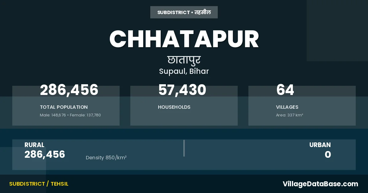
State → Bihar
Chhatapur is a town and Subdivision in the Supaul district of the Bihar. In India, a Subdivision is a subdivision of a district responsible for the administration and revenue collection of a specific area within the district. Subdivisions play a crucial role in the local governance structure, contributing significantly to the development and administration of their communities.
According to the 2011 census The total area of Chhatapur Subdivision is 337 km², with a population of 286456 people. The population density is 850 inhabitants per square kilometre, and there are approximately 57430 houses in the sub district.
Chhatapur Subdivision comprises about 64 villages. Below is a list of these villages along with information about their respective gram panchayats and the nearest town:
| # | Village Name | Gram Panchayat | Nearest Town |
|---|---|---|---|
| 1 | Bairia | Rajeshwari West | Supaul (45 km) |
| 2 | Balua | Balua | Birpur (15 km) |
| 3 | Bardaha Jainagar | Madhubani | Forbesganj (24 km) |
| 4 | Barhmotar | Laxaminia | Birpur (14 km) |
| 5 | Belaganj | Jibachh Pur | Forbesganj (18 km) |
| 6 | Bhagwatpur | Udhampur | Forbesganj (24 km) |
| 7 | Bharatpur | Lalganj | Supaul (60 km) |
| 8 | Bhatabari | Jhakhar Garh | Forbesganj (25 km) |
| 9 | Bhawanipur | Guwalpara | Forbesganj (31 km) |
| 10 | Bhawanipur Tharha | Balua | Birpur (19 km) |
| 11 | Bhimpur | Bhimpur | Forbesganj (26 km) |
| 12 | Bishunpur Ghulami | Balua | Birpur (18 km) |
| 13 | Chainpur | Thuthi | Birpur (22 km) |
| 14 | Chapain | Thuthi | Birpur (18 km) |
| 15 | Charne | Charna | Forbesganj (35 km) |
| 16 | Chhatapur | Chatapur | Forbesganj (25 km) |
| 17 | Chuni | Chunni | Forbesganj (36 km) |
| 18 | Chuni Milik | Chunni | Chhatapur |
| 19 | Darharia | Deharia | Murliganj (25 km) |
| 20 | Dhakhargaru | Jhakhar Garh | Forbesganj (28 km) |
| 21 | Dodra | Madhubani | Forbesganj (24 km) |
| 22 | Gareria Chakla | Balua | Birpur (12 km) |
| 23 | Ghiwaha | Ghibaha | Supaul (45 km) |
| 24 | Goalpara | Guwalpara | Forbesganj (31 km) |
| 25 | Gobindpur Kalan | Udhampur | Forbesganj (24 km) |
| 26 | Gurdharia | Balua | Birpur (12 km) |
| 27 | Hariharpur | Madhopur | Forbesganj (26 km) |
| 28 | Indarpur | Rampur | Forbesganj (25 km) |
| 29 | Jiwachhpur | Jibachh Pur | Forbesganj (18 km) |
| 30 | Kalikapur | Laxaminia | Forbesganj (22 km) |
| 31 | Karliana | Laxamipur Khuti | Forbesganj (46 km) |
| 32 | Katahra | Kathara | Forbesganj (24 km) |
| 33 | Kathi | Mohamad Ganj | Forbesganj (31 km) |
| 34 | Katrahi Fakirana | Rajeshwari East | Chhatapur |
| 35 | Keola | Bhimpur | Forbesganj (24 km) |
| 36 | Khuti | Laxamipur Khuti | Forbesganj (46 km) |
| 37 | Kishunganj | Chunni | Murliganj (26 km) |
| 38 | Lachhminia | Laxaminia | Forbesganj (20 km) |
| 39 | Lachhmipur | Laxamipur Khuti | Forbesganj (45 km) |
| 40 | Lalganj | Lalganj | Supaul (60 km) |
| 41 | Lalpur | Rampur | Forbesganj (27 km) |
| 42 | Madhopur | Madhopur | Forbesganj (24 km) |
| 43 | Madhubani | Madhubani | Forbesganj (26 km) |
| 44 | Mahaddipur | Udhampur | Forbesganj (25 km) |
| 45 | Mahadeopatti | Laxaminia | Birpur (16 km) |
| 46 | Mahammadganj | Mohamad Ganj | Murliganj (30 km) |
| 47 | Matiari | Balua | Birpur (20 km) |
| 48 | Mohanpur | Kathara | Forbesganj (25 km) |
| 49 | Narahia | Chatapur | Forbesganj (45 km) |
| 50 | Pariahi | Lalganj | Supaul (60 km) |
| 51 | Partapnagar | Rampur | Forbesganj (24 km) |
| 52 | Patti Niyamat Urf Girdharpatti | Sohatha | Forbesganj (30 km) |
| 53 | Patti Ratan Sar | Sohatha | Forbesganj (30 km) |
| 54 | Raisri | Rajeshwari East | Murliganj (36 km) |
| 55 | Raisri Milik | Rajeshwari West | Chhatapur |
| 56 | Rajwara | Chatapur | Forbesganj (26 km) |
| 57 | Ramnagar | Rampur | Forbesganj (27 km) |
| 58 | Rampur | Rampur | Forbesganj (26 km) |
| 59 | Ratan Sar | Guwalpara | Forbesganj (30 km) |
| 60 | Sahata | Sohatha | Forbesganj (30 km) |
| 61 | Shahpur | Chunni | Forbesganj (30 km) |
| 62 | Tengri | Laxaminia | Birpur (17 km) |
| 63 | Thuthi | Thuthi | Birpur (16 km) |
| 64 | Udhampur | Udhampur | Forbesganj (27 km) |
The population is distributed between urban and rural areas as follows:
| Particulars | Rural | Urban | Total |
|---|---|---|---|
| Total Population | 286456 | 0 | 286456 |
| Male Population | 148676 | 0 | 148676 |
| Female Population | 137780 | 0 | 137780 | Population Density | 850 / km² | 850 / km² |
The distribution of households in the Chhatapur is:
| Rural Households | Urban Households | Total Households |
|---|---|---|
| 57430 | 0 | 57430 |
Q: What is Chhatapur?
A: Chhatapur is a town and in the Supaul district of the Bihar.
Q: What is the total area of Chhatapur Subdivision?
A: The total area of Chhatapur Subdivision is 337 km².
Q: What is the population of Chhatapur Subdivision according to the 2011 census?
A: According to the 2011 census, the population of Chhatapur Subdivision is 286456.
Q: What is the population density of Chhatapur Subdivision?
A: The population density of Chhatapur Subdivision is 850 inhabitants per square kilometre.
Q: How many houses are there in Chhatapur Subdivision?
A: There are approximately 57430 houses in Chhatapur Subdivision.
Q: How many villages are there in Chhatapur Subdivision?
A: There are about 64 villages in Chhatapur Subdivision.
Q: Which is the largest village by population in Chhatapur Subdivision?
A: The largest village by population in Chhatapur Subdivision is Raisri, with 17474 people.
Q: Which is the smallest village by population in Chhatapur Subdivision?
A: The smallest village by population in Chhatapur Subdivision is Chuni Milik, with 0 people.
Q: Which is the largest village by area in Chhatapur Subdivision?
A: The largest village by area in Chhatapur Subdivision is Raisri, with 1970 km².
Q: Which is the smallest village by area in Chhatapur Subdivision?
A: The smallest village by area in Chhatapur Subdivision is Ramnagar, with 27 km².
Q: What is the population distribution between urban and rural areas in Chhatapur Subdivision?
A: The population distribution in Chhatapur Subdivision is entirely rural, with a total rural population of 286456.
Q: What is the male population of Chhatapur Subdivision?
A: The male population of Chhatapur Subdivision is 148676.
Q: What is the female population of Chhatapur Subdivision?
A: The female population of Chhatapur Subdivision is 137780.
Q: How is the household distribution in Chhatapur Subdivision?
A: The household distribution in Chhatapur Subdivision is entirely rural, with a total of 57430 households.
Q: How many villages in Chhatapur Subdivision have a population of less than 100?
A: There are 3 villages in Chhatapur Subdivision with a population of less than 100.
Q: How many villages in Chhatapur Subdivision have a population between 100 and 499?
A: There are 2 villages in Chhatapur Subdivision with a population between 100 and 499.
Q: How many villages in Chhatapur Subdivision have a population between 500 and 999?
A: There are 4 villages in Chhatapur Subdivision with a population between 500 and 999.
Q: How many villages in Chhatapur Subdivision have a population between 1000 and 1999?
A: There are 11 villages in Chhatapur Subdivision with a population between 1000 and 1999.
Q: How many villages in Chhatapur Subdivision have a population between 2000 and 2999?
A: There is 6 village in Chhatapur Subdivision with a population between 2000 and 2999.
Q: How many villages in Chhatapur Subdivision have a population between 3000 and 3999?
A: There is 11 village in Chhatapur Subdivision with a population between 3000 and 3999.
Q: How many villages in Chhatapur Subdivision have a population between 4000 and 4999?
A: There is 6 village in Chhatapur Subdivision with a population between 4000 and 4999.
Q: How many villages in Chhatapur Subdivision have a population of 5000 and above?
A: There is 21 village in Chhatapur Subdivision with a population of 5000 and above.
| Total Population | Villages in Sub District Of Chhatapur |
|---|---|
| Less than 100 | 3 |
| 100-499 | 2 |
| 500-999 | 4 |
| 1000-1999 | 11 |
| 2000-2999 | 6 |
| 3000-3999 | 11 |
| 4000-4999 | 6 |
| 5000 And Above | 21 |