Tribeniganj: A Town and Subdivision in Supaul district
District → Supaul
State → Bihar
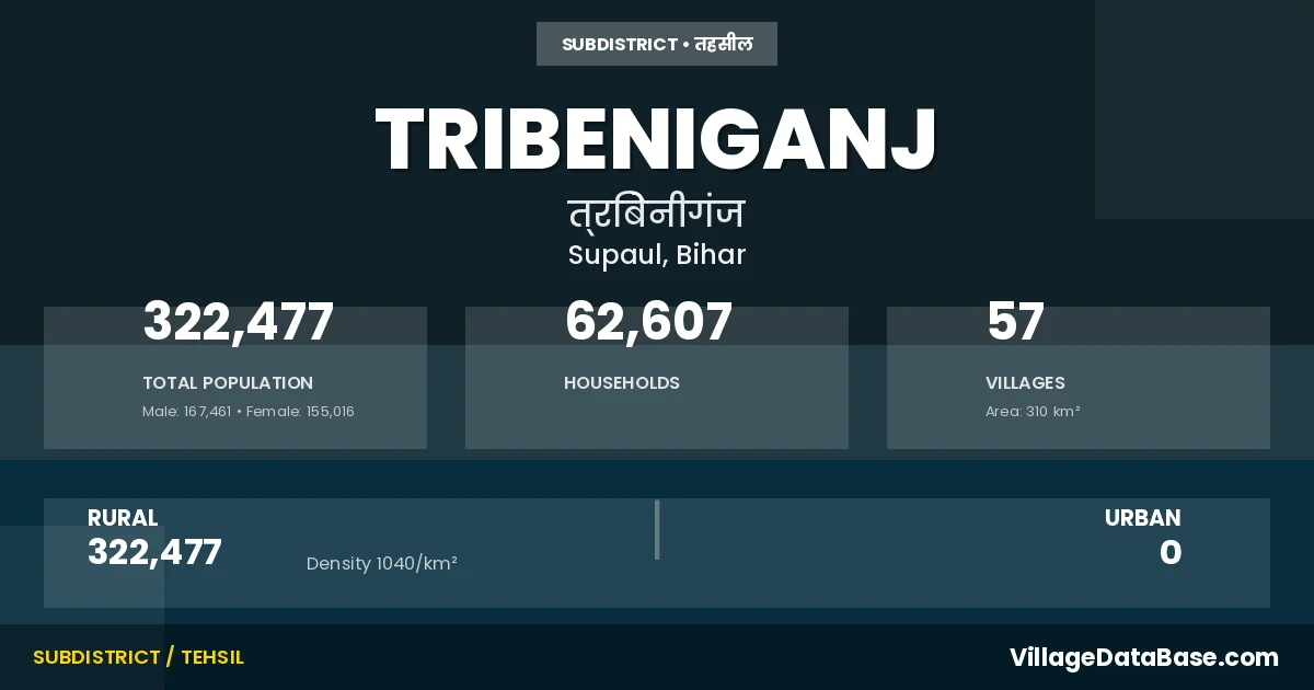
Tribeniganj is a town and Subdivision in the Supaul district of the Bihar. In India, a Subdivision is a subdivision of a district responsible for the administration and revenue collection of a specific area within the district. Subdivisions play a crucial role in the local governance structure, contributing significantly to the development and administration of their communities.
According to the 2011 census The total area of Tribeniganj Subdivision is 310 km², with a population of 322477 people. The population density is 1,040 inhabitants per square kilometre, and there are approximately 62607 houses in the sub district.
Tribeniganj Subdivision comprises about 57 villages. Below is a list of these villages along with information about their respective gram panchayats and the nearest town:
| # | Village Name | Gram Panchayat | Nearest Town |
|---|---|---|---|
| 1 | Atlakha Belahi | Simaria | Supaul (39 km) |
| 2 | Auraha | Karharwa | Madhepura (24 km) |
| 3 | Babhanganwa | Babhangama | Supaul (28 km) |
| 4 | Baghaeli | Baghely | Murliganj (20 km) |
| 5 | Barahkurwa | Barhakurba | Supaul (39 km) |
| 6 | Bela | Maheshuwa | Supaul (27 km) |
| 7 | Belapatti | Guria | Supaul (49 km) |
| 8 | Belha | Karharwa | Madhepura (24 km) |
| 9 | Bhagwanpur | Harihar Patti | Supaul (55 km) |
| 10 | Bhairapatti | Karharwa | Madhepura (24 km) |
| 11 | Bhura | Patharagour Dhoe | Supaul (25 km) |
| 12 | Bishunia | Koria Patti East | Madhepura (49 km) |
| 13 | Daparkha | Daparkha | Supaul (32 km) |
| 14 | Gamhirpur | Maheshuwa | Supaul (23 km) |
| 15 | Ganjhar Lakheraj | Harihar Patti | Supaul (53 km) |
| 16 | Ganjhar Mal | Harihar Patti | Supaul (54 km) |
| 17 | Gobindpur | Nandana | Murliganj (18 km) |
| 18 | Gorha | Gonha | Supaul (47 km) |
| 19 | Guria | Guria | Supaul (42 km) |
| 20 | Hariharpatti | Harihar Patti | Supaul (57 km) |
| 21 | Hirapatti | Koria Patti East | Madhepura (49 km) |
| 22 | Jadia | Jadia | Supaul (43 km) |
| 23 | Jagur | Patharagour Dhoe | Madhepura (25 km) |
| 24 | Karanpatti | Orlaha | Supaul (45 km) |
| 25 | Karharwa | Karharwa | Madhepura (24 km) |
| 26 | Koriapatti | Koria Patti East | Madhepura (48 km) |
| 27 | Kukur Dhari | Guria | Supaul (42 km) |
| 28 | Kusaha | Harihar Patti | Madhepura (36 km) |
| 29 | Lachhminia | Piluwaha | Murliganj (22 km) |
| 30 | Lachhmipur | Maheshuwa | Supaul (25 km) |
| 31 | Laharnia | Mirjawa | Supaul (43 km) |
| 32 | Latauna | Latona Noyrth | Supaul (30 km) |
| 33 | Mahesua | Maheshuwa | Madhepura (20 km) |
| 34 | Mahrampur Arazi | Baghely | Tribeniganj |
| 35 | Mahrampur Milik | Baghely | Tribeniganj |
| 36 | Mahulia | Piluwaha | Murliganj (18 km) |
| 37 | Manganj | Manganj East | Madhepura (35 km) |
| 38 | Maun | Simaria | Madhepura (25 km) |
| 39 | Mirjawa | Mirjawa | Supaul (41 km) |
| 40 | Mohar Rampur | Baghely | Murliganj (21 km) |
| 41 | Mohar Rampur Milik | Baghely | Murliganj (22 km) |
| 42 | Nandan | Nandana | Murliganj (18 km) |
| 43 | Nandan Milik | Nandana | Tribeniganj |
| 44 | Orlaha | Orlaha | Supaul (49 km) |
| 45 | Pakri | Maheshuwa | Supaul (31 km) |
| 46 | Pansahi | Orlaha | Supaul (49 km) |
| 47 | Parsagarhi | Parsagarhi North | Madhepura (55 km) |
| 48 | Parsagarhi Milik | Parsagarhi North | Tribeniganj |
| 49 | Pathragordhoi | Patharagour Dhoe | Madhepura (25 km) |
| 50 | Phulkaha | Jadia | Madhepura (36 km) |
| 51 | Pilwaha | Piluwaha | Supaul (40 km) |
| 52 | Purandaha | Gonha | Supaul (49 km) |
| 53 | Raghunathpur | Baghely | Madhepura (31 km) |
| 54 | Raghunathpur Milik | Baghely | Tribeniganj |
| 55 | Rahta | Maheshuwa | Supaul (25 km) |
| 56 | Semaria | Simaria | Madhepura (24 km) |
| 57 | Thalha Garhia | Thalhagarhia North | Madhepura (25 km) |
The population is distributed between urban and rural areas as follows:
| Particulars | Rural | Urban | Total |
|---|---|---|---|
| Total Population | 322477 | 0 | 322477 |
| Male Population | 167461 | 0 | 167461 |
| Female Population | 155016 | 0 | 155016 | Population Density | 1040 / km² | 1,040 / km² |
The distribution of households in the Tribeniganj is:
| Rural Households | Urban Households | Total Households |
|---|---|---|
| 62607 | 0 | 62607 |
Q: What is Tribeniganj?
A: Tribeniganj is a town and in the Supaul district of the Bihar.
Q: What is the total area of Tribeniganj Subdivision?
A: The total area of Tribeniganj Subdivision is 310 km².
Q: What is the population of Tribeniganj Subdivision according to the 2011 census?
A: According to the 2011 census, the population of Tribeniganj Subdivision is 322477.
Q: What is the population density of Tribeniganj Subdivision?
A: The population density of Tribeniganj Subdivision is 1,040 inhabitants per square kilometre.
Q: How many houses are there in Tribeniganj Subdivision?
A: There are approximately 62607 houses in Tribeniganj Subdivision.
Q: How many villages are there in Tribeniganj Subdivision?
A: There are about 57 villages in Tribeniganj Subdivision.
Q: Which is the largest village by population in Tribeniganj Subdivision?
A: The largest village by population in Tribeniganj Subdivision is Thalha Garhia, with 22723 people.
Q: Which is the smallest village by population in Tribeniganj Subdivision?
A: The smallest village by population in Tribeniganj Subdivision is Mahrampur Arazi, with 0 people.
Q: Which is the largest village by area in Tribeniganj Subdivision?
A: The largest village by area in Tribeniganj Subdivision is Thalha Garhia, with 2450 km².
Q: Which is the smallest village by area in Tribeniganj Subdivision?
A: The smallest village by area in Tribeniganj Subdivision is Raghunathpur Milik, with 11 km².
Q: What is the population distribution between urban and rural areas in Tribeniganj Subdivision?
A: The population distribution in Tribeniganj Subdivision is entirely rural, with a total rural population of 322477.
Q: What is the male population of Tribeniganj Subdivision?
A: The male population of Tribeniganj Subdivision is 167461.
Q: What is the female population of Tribeniganj Subdivision?
A: The female population of Tribeniganj Subdivision is 155016.
Q: How is the household distribution in Tribeniganj Subdivision?
A: The household distribution in Tribeniganj Subdivision is entirely rural, with a total of 62607 households.
Q: How many villages in Tribeniganj Subdivision have a population of less than 100?
A: There are 5 villages in Tribeniganj Subdivision with a population of less than 100.
Q: How many villages in Tribeniganj Subdivision have a population between 100 and 499?
A: There are 1 villages in Tribeniganj Subdivision with a population between 100 and 499.
Q: How many villages in Tribeniganj Subdivision have a population between 500 and 999?
A: There are 5 villages in Tribeniganj Subdivision with a population between 500 and 999.
Q: How many villages in Tribeniganj Subdivision have a population between 1000 and 1999?
A: There are 8 villages in Tribeniganj Subdivision with a population between 1000 and 1999.
Q: How many villages in Tribeniganj Subdivision have a population between 2000 and 2999?
A: There is 7 village in Tribeniganj Subdivision with a population between 2000 and 2999.
Q: How many villages in Tribeniganj Subdivision have a population between 3000 and 3999?
A: There is 6 village in Tribeniganj Subdivision with a population between 3000 and 3999.
Q: How many villages in Tribeniganj Subdivision have a population between 4000 and 4999?
A: There is 4 village in Tribeniganj Subdivision with a population between 4000 and 4999.
Q: How many villages in Tribeniganj Subdivision have a population of 5000 and above?
A: There is 21 village in Tribeniganj Subdivision with a population of 5000 and above.
| Total Population | Villages in Sub District Of Tribeniganj |
|---|---|
| Less than 100 | 5 |
| 100-499 | 1 |
| 500-999 | 5 |
| 1000-1999 | 8 |
| 2000-2999 | 7 |
| 3000-3999 | 6 |
| 4000-4999 | 4 |
| 5000 And Above | 21 |