District → Bilaspur
State → Chhattisgarh
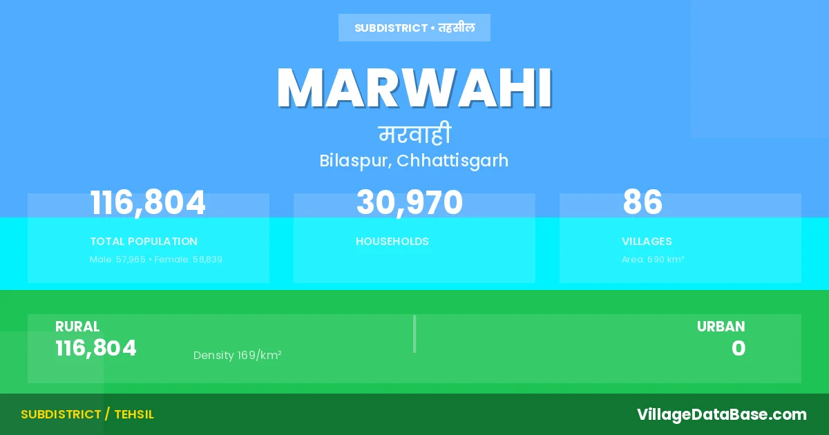
Marwahi is a town and Tehsil in the Bilaspur district of the Chhattisgarh. In India, a Tehsil is a subdivision of a district responsible for the administration and revenue collection of a specific area within the district. Tehsils play a crucial role in the local governance structure, contributing significantly to the development and administration of their communities.
According to the 2011 census The total area of Marwahi Tehsil is 690 km², with a population of 116804 people. The population density is 169 inhabitants per square kilometre, and there are approximately 30970 houses in the sub district.
Marwahi Tehsil comprises about 86 villages. Below is a list of these villages along with information about their respective gram panchayats and the nearest town:
| # | Village Name | Gram Panchayat | Nearest Town |
|---|---|---|---|
| 1 | Amera Tikra | Ameratikra | Pendra (38 km) |
| 2 | Andi | Andi | Pendra (8 km) |
| 3 | Badraudi | Badrodi | Pendra (40 km) |
| 4 | Bagdi | Bagadi | Pendra (12 km) |
| 5 | Bagrad | Bagrar | Manendragarh (30 km) |
| 6 | Bahrijhorki | Ghummatola | Manendragarh (35 km) |
| 7 | Bahutadol | Patharri | Bilaspur (140 km) |
| 8 | Bandhauri | Bandhouri | Pendra (22 km) |
| 9 | Banshital | Bansital | Pendra (35 km) |
| 10 | Baraur | Baror | Manendragarh (31 km) |
| 11 | Bargawan | Pendra (26 km) | |
| 12 | Beljhiriya | Beljhiriya | Pendra (56 km) |
| 13 | Bharridand | Bharridand | Pendra (28 km) |
| 14 | Chachedi | Chchedi | Bilaspur (135 km) |
| 15 | Chanadongri | Chanadongari | Pendra (45 km) |
| 16 | Changeri | Changeri | Manendragarh (45 km) |
| 17 | Chichghona | Chichgohana | Pendra (41 km) |
| 18 | Dandiya | Pondi | Pendra (40 km) |
| 19 | Danikundi | Bansital | Pendra (40 km) |
| 20 | Darmohali | Darmohli | Pendra (25 km) |
| 21 | Deogawan | Badrodi | Pendra (45 km) |
| 22 | Deori Dand | Sacharatola | Gaurella (40 km) |
| 23 | Dhanaura | Dhanora | Pendra (57 km) |
| 24 | Dhanpur | Dhanpur | Pendra (13 km) |
| 25 | Dharhar | Dharhar | Bilaspur (135 km) |
| 26 | Dhaubahar | Dhobhar | Pendra (15 km) |
| 27 | Dhitora | Barganwa | Pendra (25 km) |
| 28 | Dhummatola | Ghummatola | Manendragarh (34 km) |
| 29 | Dongariya | Dongriya | Pendra (13 km) |
| 30 | Dongratola | Ameratikra | Pendra (25 km) |
| 31 | Dumarkherawa | Nagwahi | Pendra (9 km) |
| 32 | Enthi | Dharhar | Bilaspur (136 km) |
| 33 | Ganaya | Dhanora | Manendragarh (30 km) |
| 34 | Ghinauchi | Maladand | Pendra (42 km) |
| 35 | Ghusaria | Chchedi | Bilaspur (135 km) |
| 36 | Gudumdeori | Gudumdevari | Pendra (9 km) |
| 37 | Gullidand | Gullidand | Pendra (32 km) |
| 38 | Jhiriyatola | Bagrar | Pendra (47 km) |
| 39 | Kachhar | Kachar | Manendragarh (36 km) |
| 40 | Kargikalan | Kargikala | Pendra (40 km) |
| 41 | Karhani | Karhani | Pendra (43 km) |
| 42 | Karhaniya | Kachar | Pendra (50 km) |
| 43 | Karsiwa | Karsiva | Pendra (18 km) |
| 44 | Katra | Katra | Pendra (52 km) |
| 45 | Khurpa | Khurpa | Pendra (25 km) |
| 46 | Kodawahi | Latkonikhurd | Pendra (9 km) |
| 47 | Kolbira | Patharra | Pendra (25 km) |
| 48 | Kumhari | Kumhari | Pendra (37 km) |
| 49 | Larkeni | Larkeni | Pendra (15 km) |
| 50 | Latkoni Khurd | Latkonikhurd | Pendra (10 km) |
| 51 | Litiyasarai | Gullidand | Gaurella (42 km) |
| 52 | Lohari | Lohari | Pendra (41 km) |
| 53 | Madai | Madai | Pendra (25 km) |
| 54 | Madakot | Kumhari | Pendra (35 km) |
| 55 | Madwahi | Madwahi | Bilaspur (132 km) |
| 56 | Magurda | Magurada | Gaurella (35 km) |
| 57 | Mahora | Mahora | Pendra (8 km) |
| 58 | Majhganwan | Majhgawa | Pendra (7 km) |
| 59 | Maladand | Maladand | Pendra (50 km) |
| 60 | Manaura | Manaora | Pendra (50 km) |
| 61 | Marwahi | Marwahi | Pendra (45 km) |
| 62 | Masurikhar | Masurikhar | Pendra (15 km) |
| 63 | Matiyadand | Matiadand | Pendra (28 km) |
| 64 | Mouharitola | Ameratikra | Pendra (36 km) |
| 65 | Nagawahi | Nagwahi | Pendra (10 km) |
| 66 | Naka | Naka | Pendra (38 km) |
| 67 | Naraur | Narour | Pendra (18 km) |
| 68 | Nimdha | Nimdha | Pendra (20 km) |
| 69 | Pandri | Pandri | Bilaspur (145 km) |
| 70 | Parasi | Parasi | Manendragarh (35 km) |
| 71 | Patharra | Patharra | Pendra (20 km) |
| 72 | Patharri | Patharri | Pendra (42 km) |
| 73 | Piperdol | Gullidand | Gaurella (50 km) |
| 74 | Pondi | Pondi | Pendra (40 km) |
| 75 | Rajadih | Ratga | Gaurella (50 km) |
| 76 | Ratga | Ratga | Pendra (25 km) |
| 77 | Rumga | Rumga | Pendra (26 km) |
| 78 | Sacharatola | Sacharatola | Gaurella (40 km) |
| 79 | Salhekota | Salhekota | Pendra (18 km) |
| 80 | Sekhwa | Sekhwa | Pendra (20 km) |
| 81 | Semardarri | Semardarri | Gaurella (40 km) |
| 82 | Seoni | Seoni | Pendra (35 km) |
| 83 | Silpahari | Silpahri | Pendra (15 km) |
| 84 | Tendumuda | Tendumuda | Manendragarh (35 km) |
| 85 | Tikathi | Tikthi | Manendragarh (33 km) |
| 86 | Usarh | Usadh | Pendra (57 km) |
The population is distributed between urban and rural areas as follows:
| Particulars | Rural | Urban | Total |
|---|---|---|---|
| Total Population | 116804 | 0 | 116804 |
| Male Population | 57965 | 0 | 57965 |
| Female Population | 58839 | 0 | 58839 | Population Density | 169 / km² | 169 / km² |
The distribution of households in the Marwahi is:
| Rural Households | Urban Households | Total Households |
|---|---|---|
| 30970 | 0 | 30970 |
Q: What is Marwahi?
A: Marwahi is a town and in the Bilaspur district of the Chhattisgarh.
Q: What is the total area of Marwahi Tehsil?
A: The total area of Marwahi Tehsil is 690 km².
Q: What is the population of Marwahi Tehsil according to the 2011 census?
A: According to the 2011 census, the population of Marwahi Tehsil is 116804.
Q: What is the population density of Marwahi Tehsil?
A: The population density of Marwahi Tehsil is 169 inhabitants per square kilometre.
Q: How many houses are there in Marwahi Tehsil?
A: There are approximately 30970 houses in Marwahi Tehsil.
Q: How many villages are there in Marwahi Tehsil?
A: There are about 86 villages in Marwahi Tehsil.
Q: Which is the largest village by population in Marwahi Tehsil?
A: The largest village by population in Marwahi Tehsil is Marwahi, with 4060 people.
Q: Which is the smallest village by population in Marwahi Tehsil?
A: The smallest village by population in Marwahi Tehsil is Bahrijhorki, with 246 people.
Q: Which is the largest village by area in Marwahi Tehsil?
A: The largest village by area in Marwahi Tehsil is Katra, with 4246 km².
Q: Which is the smallest village by area in Marwahi Tehsil?
A: The smallest village by area in Marwahi Tehsil is Bahrijhorki, with 131 km².
Q: What is the population distribution between urban and rural areas in Marwahi Tehsil?
A: The population distribution in Marwahi Tehsil is entirely rural, with a total rural population of 116804.
Q: What is the male population of Marwahi Tehsil?
A: The male population of Marwahi Tehsil is 57965.
Q: What is the female population of Marwahi Tehsil?
A: The female population of Marwahi Tehsil is 58839.
Q: How is the household distribution in Marwahi Tehsil?
A: The household distribution in Marwahi Tehsil is entirely rural, with a total of 30970 households.
Q: How many villages in Marwahi Tehsil have a population between 100 and 499?
A: There are 9 villages in Marwahi Tehsil with a population between 100 and 499.
Q: How many villages in Marwahi Tehsil have a population between 500 and 999?
A: There are 23 villages in Marwahi Tehsil with a population between 500 and 999.
Q: How many villages in Marwahi Tehsil have a population between 1000 and 1999?
A: There are 41 villages in Marwahi Tehsil with a population between 1000 and 1999.
Q: How many villages in Marwahi Tehsil have a population between 2000 and 2999?
A: There is 8 village in Marwahi Tehsil with a population between 2000 and 2999.
Q: How many villages in Marwahi Tehsil have a population between 3000 and 3999?
A: There is 4 village in Marwahi Tehsil with a population between 3000 and 3999.
Q: How many villages in Marwahi Tehsil have a population between 4000 and 4999?
A: There is 1 village in Marwahi Tehsil with a population between 4000 and 4999.
| Total Population | Villages in Sub District Of Marwahi |
|---|---|
| 100-499 | 9 |
| 500-999 | 23 |
| 1000-1999 | 41 |
| 2000-2999 | 8 |
| 3000-3999 | 4 |
| 4000-4999 | 1 |