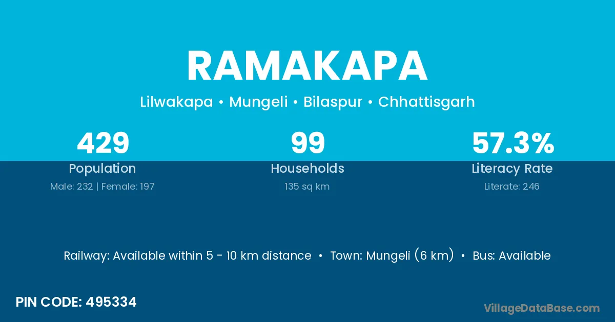
Ramakapa village is located in the Mungeli Tehsil of the Bilaspur district in Chhattisgarh .
Block / Tehsil → Mungeli
District → Bilaspur
State → Chhattisgarh
According to Census 2011 information, the village code of Ramakapa village is 495334.
Ramakapa village has a total population of 429 people, of which 232 are males and 197 are females.
The literacy rate of Ramakapa village is 57.34%. Male literacy stands at 68.10% and female literacy at 44.67%.
There are approximately 99 households in Ramakapa village.
Mungeli (6 km) is the nearest town to Ramakapa village for major economic activities and is located approximately 6 km away.
The population of Ramakapa village is distributed between literate and illiterate residents as follows:
| Particulars | Male | Female | Total |
|---|---|---|---|
| Literate | 158 | 88 | 246 |
| Illiterate | 74 | 109 | 183 |
| Total | 232 | 197 | 429 |
Source: Census 2011
| Village | District |
|---|---|
| Amalidih | Bilaspur |
| Amalidih | Janjgir Champa |
| Amalidih | Kabeerdham |
| Amalidih | Kabeerdham |
| Amalidih | Raipur |
| Baghamuda | Bilaspur |
| Baghamuda | Kabeerdham |
| Baghamuda | Mahasamund |
| Bhadukapa | Bilaspur |
| Dulhinbai | Bilaspur |
| Jethukapa | Bilaspur |
| Jhagarhata | Bilaspur |
| Khairwar | Saran |
| Khairwar | Bilaspur |
| Khairwar | Kabeerdham |
| Khairwar | Surguja |
| Mohamadwa | Bilaspur |
| Nuniakachhar | Bilaspur |
| Palchua | Bilaspur |
| Suretha | Bilaspur |
| Suretha | Bilaspur |
No reviews yet. Be the first to review this village!
Available within 5 - 10 km distance
Available
Available within 5 - 10 km distance