Pamgarh: A Town and Tehsil in Janjgir Champa district
District → Janjgir Champa
State → Chhattisgarh
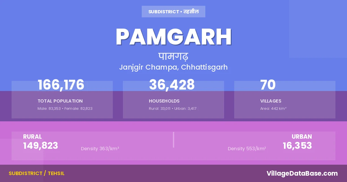
Pamgarh is a town and Tehsil in the Janjgir Champa district of the Chhattisgarh. In India, a Tehsil is a subdivision of a district responsible for the administration and revenue collection of a specific area within the district. Tehsils play a crucial role in the local governance structure, contributing significantly to the development and administration of their communities.
According to the 2011 census The total area of Pamgarh Tehsil is 442 km², with a population of 166176 people. The population density is 376 inhabitants per square kilometre, and there are approximately 36428 houses in the sub district.
Pamgarh Tehsil comprises about 70 villages. Below is a list of these villages along with information about their respective gram panchayats and the nearest town:
| # | Village Name | Gram Panchayat | Nearest Town |
|---|---|---|---|
| 1 | Bargaon | Bargaon | Rahaud (6 km) |
| 2 | Bhadra | Bhadara | Rahaud (15 km) |
| 3 | Bhainso | Bhaiso | Akaltara (20 km) |
| 4 | Bhawtara | Bhawtara | Rahaud (5 km) |
| 5 | Bhilauni | Bhilouni | Rahaud (17 km) |
| 6 | Bhuigaon | Bhuigaon | Kharod (18 km) |
| 7 | Bilari | Bilari | Rahaud (3 km) |
| 8 | Bohardih | Dhighora | Rahaud (40 km) |
| 9 | Borsi | Borasi | Akaltara (27 km) |
| 10 | Bundela | Bundela | Rahaud (4 km) |
| 11 | Chandipara | Chandipara | Rahaud (11 km) |
| 12 | Cheudih | Cheudih | Rahaud (6 km) |
| 13 | Chorbhatti | Chorbhatthi | Akaltara (10 km) |
| 14 | Churtela | Churtela | Rahaud (19 km) |
| 15 | Deori | Devari | Kharod (3 km) |
| 16 | Dewarghata | Kamarid | Kharod (12 km) |
| 17 | Dhangaon | Dhangaon | Rahaud (18 km) |
| 18 | Dhardehi | Dhardei | Rahaud (2 km) |
| 19 | Dighora | Dhighora | Akaltara (30 km) |
| 20 | Donga Kohraud | Dongakohrod | Rahaud (15 km) |
| 21 | Dudga | Dudaga | Rahaud (17 km) |
| 22 | Hadha | Padariya | Rahaud (6 km) |
| 23 | Hedaspur | Pachari | Rahaud (14 km) |
| 24 | Hirri | Hirri | Rahaud (20 km) |
| 25 | Jewara | Jewara | Pamgarh (15 km) |
| 26 | Jhilmili | Jhilmili | Akaltara (18 km) |
| 27 | Jhulan | Jhulan | Rahaud (12 km) |
| 28 | Jogidipa | Jogidipa | Akaltara (18 km) |
| 29 | Kamreed | Kamarid | Kharod (35 km) |
| 30 | Kesala | Kesala | Rahaud (17 km) |
| 31 | Khairadih | Kharkhod | Rahaud (21 km) |
| 32 | Khapri | Khapari | Akaltara (15 km) |
| 33 | Khargahni | Khargahni | Kharod (10 km) |
| 34 | Kharkhod | Kharkhod | Rahaud (19 km) |
| 35 | Khokhari | Khokhari | Rahaud (4 km) |
| 36 | Khorsi | Khorasi | Kharod (5 km) |
| 37 | Kodabhat | Kodabhath | Rahaud (14 km) |
| 38 | Kohaka | Kohaka | Rahaud (4 km) |
| 39 | Konar | Konargarh | Rahaud (17 km) |
| 40 | Kosa | Kosa | Rahaud (18 km) |
| 41 | Kosala | Kosala | Kharod (27 km) |
| 42 | Kosir | Kosir | Rahaud (21 km) |
| 43 | Kutrabod | Kutarabod | Rahaud (13 km) |
| 44 | Lagra | Lagara | Akaltara (17 km) |
| 45 | Loharsi | Loharsi | Rahaud (5 km) |
| 46 | Mahka | Mahka | Rahaud (3 km) |
| 47 | Masturidih | Mulmula | Akaltara (16 km) |
| 48 | Mehandi | Mehadi | Rahaud (2 km) |
| 49 | Mekri | Mekari | Rahaud (17 km) |
| 50 | Meu | Meu | Rahaud (8 km) |
| 51 | Mudpar | Mudpar Ba | Rahaud (17 km) |
| 52 | Mulmula | Mulmula | Akaltara (16 km) |
| 53 | Nandeli | Nandeli | Rahaud (18 km) |
| 54 | Pachari | Pachari | Akaltara (14 km) |
| 55 | Padariya | Padariya | Rahaud (5 km) |
| 56 | Pakariya | Pakariya | Rahaud (5 km) |
| 57 | Pamgarh | Pamgarh | Rahaud (10 km) |
| 58 | Pandari | Pendri | Rahaud (9 km) |
| 59 | Pangaon | Pangaon | Rahaud (8 km) |
| 60 | Rasonta | Rasouta | Rahaud (10 km) |
| 61 | Rewapar | Khokhari | Rahaud (4 km) |
| 62 | Rojhandih | Chandipara | Rahaud (14 km) |
| 63 | Sasha | Sasaha | Rahaud (24 km) |
| 64 | Semariya | Dhighora | Pamgarh (11 km) |
| 65 | Singhaldeep | Padariya | Rahaud (5 km) |
| 66 | Sirli | Silli | Akaltara (20 km) |
| 67 | Sirri | Sirri | Rahaud (21 km) |
| 68 | Suklabhatha | Sasaha | Rahaud (27 km) |
| 69 | Tanaud | Tanoud | Kharod (10 km) |
| 70 | Tavandih | Mulmula | Akaltara (13 km) |
The population is distributed between urban and rural areas as follows:
| Particulars | Rural | Urban | Total |
|---|---|---|---|
| Total Population | 149823 | 16353 | 166176 |
| Male Population | 75150 | 8203 | 83353 |
| Female Population | 74673 | 8150 | 82823 | Population Density | 363 / km² | 553 / km² | 376 / km² |
The distribution of households in the Pamgarh is:
| Rural Households | Urban Households | Total Households |
|---|---|---|
| 33011 | 3417 | 36428 |
Q: What is Pamgarh?
A: Pamgarh is a town and in the Janjgir Champa district of the Chhattisgarh.
Q: What is the total area of Pamgarh Tehsil?
A: The total area of Pamgarh Tehsil is 442 km².
Q: What is the population of Pamgarh Tehsil according to the 2011 census?
A: According to the 2011 census, the population of Pamgarh Tehsil is 166176.
Q: What is the population density of Pamgarh Tehsil?
A: The population density of Pamgarh Tehsil is 376 inhabitants per square kilometre.
Q: How many houses are there in Pamgarh Tehsil?
A: There are approximately 36428 houses in Pamgarh Tehsil.
Q: How many villages are there in Pamgarh Tehsil?
A: There are about 70 villages in Pamgarh Tehsil.
Q: Which is the largest village by population in Pamgarh Tehsil?
A: The largest village by population in Pamgarh Tehsil is Pamgarh, with 6064 people.
Q: Which is the smallest village by population in Pamgarh Tehsil?
A: The smallest village by population in Pamgarh Tehsil is Masturidih, with 0 people.
Q: Which is the largest village by area in Pamgarh Tehsil?
A: The largest village by area in Pamgarh Tehsil is Kosa, with 2048 km².
Q: Which is the smallest village by area in Pamgarh Tehsil?
A: The smallest village by area in Pamgarh Tehsil is Khairadih, with 85 km².
Q: What is the male population of Pamgarh Tehsil?
A: The male population of Pamgarh Tehsil is 83353.
Q: What is the female population of Pamgarh Tehsil?
A: The female population of Pamgarh Tehsil is 82823.
Q: How many villages in Pamgarh Tehsil have a population of less than 100?
A: There are 2 villages in Pamgarh Tehsil with a population of less than 100.
Q: How many villages in Pamgarh Tehsil have a population between 100 and 499?
A: There are 5 villages in Pamgarh Tehsil with a population between 100 and 499.
Q: How many villages in Pamgarh Tehsil have a population between 500 and 999?
A: There are 6 villages in Pamgarh Tehsil with a population between 500 and 999.
Q: How many villages in Pamgarh Tehsil have a population between 1000 and 1999?
A: There are 24 villages in Pamgarh Tehsil with a population between 1000 and 1999.
Q: How many villages in Pamgarh Tehsil have a population between 2000 and 2999?
A: There is 19 village in Pamgarh Tehsil with a population between 2000 and 2999.
Q: How many villages in Pamgarh Tehsil have a population between 3000 and 3999?
A: There is 4 village in Pamgarh Tehsil with a population between 3000 and 3999.
Q: How many villages in Pamgarh Tehsil have a population between 4000 and 4999?
A: There is 7 village in Pamgarh Tehsil with a population between 4000 and 4999.
Q: How many villages in Pamgarh Tehsil have a population of 5000 and above?
A: There is 3 village in Pamgarh Tehsil with a population of 5000 and above.
| Total Population | Villages in Sub District Of Pamgarh |
|---|---|
| Less than 100 | 2 |
| 100-499 | 5 |
| 500-999 | 6 |
| 1000-1999 | 24 |
| 2000-2999 | 19 |
| 3000-3999 | 4 |
| 4000-4999 | 7 |
| 5000 And Above | 3 |