Kansabel: A Town and Tehsil in Jashpur district
District → Jashpur
State → Chhattisgarh
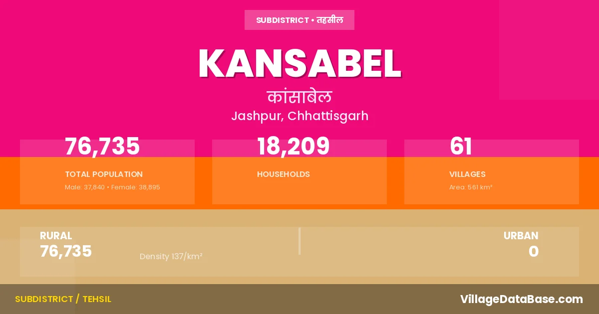
Kansabel is a town and Tehsil in the Jashpur district of the Chhattisgarh. In India, a Tehsil is a subdivision of a district responsible for the administration and revenue collection of a specific area within the district. Tehsils play a crucial role in the local governance structure, contributing significantly to the development and administration of their communities.
According to the 2011 census The total area of Kansabel Tehsil is 561 km², with a population of 76735 people. The population density is 137 inhabitants per square kilometre, and there are approximately 18209 houses in the sub district.
Kansabel Tehsil comprises about 61 villages. Below is a list of these villages along with information about their respective gram panchayats and the nearest town:
| # | Village Name | Gram Panchayat | Nearest Town |
|---|---|---|---|
| 1 | Bagiya | Bagiya | Jashpur Nagar (60 km) |
| 2 | Baiga Amba | Kodaliya | Kunkuri (28 km) |
| 3 | Bamhanmunda | Naktimunda | Kunkuri (27 km) |
| 4 | Bansbahar | Bansbahar | Jashpur Nagar (63 km) |
| 5 | Barjor | Barjor | Jashpur Nagar (79 km) |
| 6 | Bataikela | Bataikela | Kunkuri (39 km) |
| 7 | Bihabal | Patrapali | Kunkuri (27 km) |
| 8 | Chetawa | Chetba | Kunkuri (20 km) |
| 9 | Chhera Ghoghra | Chheraghoghara | Kunkuri (19 km) |
| 10 | Chidora | Chidora | Kansabel (9 km) |
| 11 | Chongribahar | Chongribahar | Jashpur Nagar (65 km) |
| 12 | Dalhagoda | Naktimunda | Kunkuri (30 km) |
| 13 | Dandajor | Farsajudwain | Jashpur Nagar (72 km) |
| 14 | Dandpani | Dandpani | Kunkuri (31 km) |
| 15 | Deori | Deori | Kunkuri (28 km) |
| 16 | Dhudhru Dand | Sujibahar | Jashpur Nagar (65 km) |
| 17 | Dokada | Dokda | Kunkuri (24 km) |
| 18 | Farsa Judwain | Farsajudwain | Jashpur Nagar (72 km) |
| 19 | Garaibandh | Sabadmunda | Jashpur Nagar (88 km) |
| 20 | Gariya Dohar | Patrapali | Kunkuri (24 km) |
| 21 | Hathgarha | Hathgada | Jashpur Nagar (74 km) |
| 22 | Jam Muda | Katangkhar | Jashpur Nagar (68 km) |
| 23 | Jumai Kela | Jumaikela | Kunkuri (24 km) |
| 24 | Kansabel | Kansabel | Kunkuri (26 km) |
| 25 | Katangkhar | Katangkhar | Jashpur Nagar (72 km) |
| 26 | Kenadand | Sagibhawana | Kunkuri (34 km) |
| 27 | Kharpani | Sagibhawana | Kunkuri (39 km) |
| 28 | Khuntitoli | Raidih | Kunkuri (24 km) |
| 29 | Khutera | Khutera | Kunkuri (31 km) |
| 30 | Kodliya | Kodaliya | Kunkuri (39 km) |
| 31 | Koranga | Koranga | Jashpur Nagar (52 km) |
| 32 | Kotanpani | Kotanpani | Jashpur Nagar (88 km) |
| 33 | Kusumtal | Kusumtal | Kansabel (5 km) |
| 34 | Lamdand | Pongro | Jashpur Nagar (79 km) |
| 35 | Lapai | Semarkachhar | Jashpur Nagar (83 km) |
| 36 | Madia Jhariya | Kenadand | Kunkuri (23 km) |
| 37 | Madwa Kani | Sabadmunda | Jashpur Nagar (86 km) |
| 38 | Muskuti | Bagiya | Jashpur Nagar (56 km) |
| 39 | Nakati Munda | Naktimunda | Jashpur Nagar (70 km) |
| 40 | Nakbar | Nakbar | Kansabel (22 km) |
| 41 | Narayan Bahali | Chetba | Kunkuri (23 km) |
| 42 | Nariyar Dand | Nariyardand | Kunkuri (25 km) |
| 43 | Pakar Toli | Koranga | Jashpur Nagar (50 km) |
| 44 | Patartora | Naktimunda | Kunkuri (35 km) |
| 45 | Patrapali | Patrapali | Kunkuri (24 km) |
| 46 | Pongro | Pongro | Jashpur Nagar (74 km) |
| 47 | Pusra | Pusra | Kunkuri (28 km) |
| 48 | Rajouti | Rajoti | Jashpur Nagar (57 km) |
| 49 | Rebda | Sabadmunda | Jashpur Nagar (84 km) |
| 50 | Sagibhouna | Sagibhawana | Kunkuri (34 km) |
| 51 | Sajapani | Sajapani | Kansabel (5 km) |
| 52 | Semar Kachhar | Semarkachhar | Jashpur Nagar (84 km) |
| 53 | Shabdmunda | Sabadmunda | Jashpur Nagar (86 km) |
| 54 | Siharbud | Siharbud | Jashpur Nagar (72 km) |
| 55 | Sikariya | Sujibahar | Jashpur Nagar (55 km) |
| 56 | Sikipani | Kenadand | Kunkuri (20 km) |
| 57 | Sujibahar | Sujibahar | Jashpur Nagar (55 km) |
| 58 | Tangargaon | Tangargaon | Jashpur Nagar (72 km) |
| 59 | Tatidand | Kotanpani | Jashpur Nagar (85 km) |
| 60 | Tilanga | Tilanga | Jashpur Nagar (88 km) |
| 61 | Turangakhar | Bansbahar | Jashpur Nagar (65 km) |
The population is distributed between urban and rural areas as follows:
| Particulars | Rural | Urban | Total |
|---|---|---|---|
| Total Population | 76735 | 0 | 76735 |
| Male Population | 37840 | 0 | 37840 |
| Female Population | 38895 | 0 | 38895 | Population Density | 137 / km² | 137 / km² |
The distribution of households in the Kansabel is:
| Rural Households | Urban Households | Total Households |
|---|---|---|
| 18209 | 0 | 18209 |
Q: What is Kansabel?
A: Kansabel is a town and in the Jashpur district of the Chhattisgarh.
Q: What is the total area of Kansabel Tehsil?
A: The total area of Kansabel Tehsil is 561 km².
Q: What is the population of Kansabel Tehsil according to the 2011 census?
A: According to the 2011 census, the population of Kansabel Tehsil is 76735.
Q: What is the population density of Kansabel Tehsil?
A: The population density of Kansabel Tehsil is 137 inhabitants per square kilometre.
Q: How many houses are there in Kansabel Tehsil?
A: There are approximately 18209 houses in Kansabel Tehsil.
Q: How many villages are there in Kansabel Tehsil?
A: There are about 61 villages in Kansabel Tehsil.
Q: Which is the largest village by population in Kansabel Tehsil?
A: The largest village by population in Kansabel Tehsil is Bataikela, with 5496 people.
Q: Which is the smallest village by population in Kansabel Tehsil?
A: The smallest village by population in Kansabel Tehsil is Patartora, with 132 people.
Q: Which is the largest village by area in Kansabel Tehsil?
A: The largest village by area in Kansabel Tehsil is Nakbar, with 2720 km².
Q: Which is the smallest village by area in Kansabel Tehsil?
A: The smallest village by area in Kansabel Tehsil is Bamhanmunda, with 92 km².
Q: What is the population distribution between urban and rural areas in Kansabel Tehsil?
A: The population distribution in Kansabel Tehsil is entirely rural, with a total rural population of 76735.
Q: What is the male population of Kansabel Tehsil?
A: The male population of Kansabel Tehsil is 37840.
Q: What is the female population of Kansabel Tehsil?
A: The female population of Kansabel Tehsil is 38895.
Q: How is the household distribution in Kansabel Tehsil?
A: The household distribution in Kansabel Tehsil is entirely rural, with a total of 18209 households.
Q: How many villages in Kansabel Tehsil have a population between 100 and 499?
A: There are 14 villages in Kansabel Tehsil with a population between 100 and 499.
Q: How many villages in Kansabel Tehsil have a population between 500 and 999?
A: There are 20 villages in Kansabel Tehsil with a population between 500 and 999.
Q: How many villages in Kansabel Tehsil have a population between 1000 and 1999?
A: There are 17 villages in Kansabel Tehsil with a population between 1000 and 1999.
Q: How many villages in Kansabel Tehsil have a population between 2000 and 2999?
A: There is 5 village in Kansabel Tehsil with a population between 2000 and 2999.
Q: How many villages in Kansabel Tehsil have a population between 3000 and 3999?
A: There is 1 village in Kansabel Tehsil with a population between 3000 and 3999.
Q: How many villages in Kansabel Tehsil have a population between 4000 and 4999?
A: There is 2 village in Kansabel Tehsil with a population between 4000 and 4999.
Q: How many villages in Kansabel Tehsil have a population of 5000 and above?
A: There is 2 village in Kansabel Tehsil with a population of 5000 and above.
| Total Population | Villages in Sub District Of Kansabel |
|---|---|
| 100-499 | 14 |
| 500-999 | 20 |
| 1000-1999 | 17 |
| 2000-2999 | 5 |
| 3000-3999 | 1 |
| 4000-4999 | 2 |
| 5000 And Above | 2 |