District → Raipur
State → Chhattisgarh
Deobhog is a town and Tehsil in the Raipur district of the Chhattisgarh. In India, a Tehsil is a subdivision of a district responsible for the administration and revenue collection of a specific area within the district. Tehsils play a crucial role in the local governance structure, contributing significantly to the development and administration of their communities.
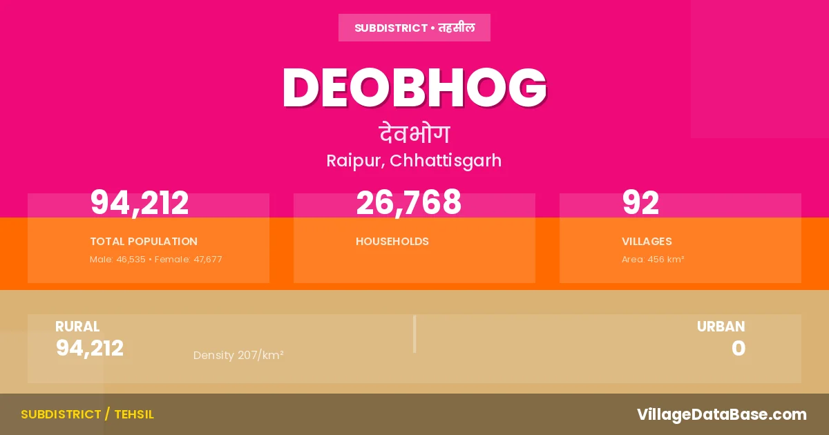
According to the 2011 census The total area of Deobhog Tehsil is 456 km², with a population of 94212 people. The population density is 207 inhabitants per square kilometre, and there are approximately 26768 houses in the sub district.
Deobhog Tehsil comprises about 92 villages. Below is a list of these villages along with information about their respective gram panchayats and the nearest town:
| # | Village Name | Gram Panchayat | Nearest Town |
|---|---|---|---|
| 1 | Amad | Amad | Gariyaband (136 km) |
| 2 | Badigaon | Badigaon | Gariyaband (133 km) |
| 3 | Barbahli | Barbahali | Deobhog |
| 4 | Barhi | Sukli Bhatta Navin | Gariyaband (120 km) |
| 5 | Barkani | Barkani | Gariyaband (141 km) |
| 6 | Bhathra Bahli | Bhatrabahli | Gariyaband (124 km) |
| 7 | Bisipara | Usripani | Gariyaband (147 km) |
| 8 | Chichiya | Chichiya | Deobhog |
| 9 | Dabnai | Dahigaon | Gariyaband (133 km) |
| 10 | Dabribhatha | Sukli Bhatta Navin | Gariyaband (122 km) |
| 11 | Dahigaon | Dahigaon | Gariyaband (135 km) |
| 12 | Darlipara | Darlipara | Gariyaband (136 km) |
| 13 | Deobhog | Deobhog | Gariyaband (127 km) |
| 14 | Dhamanbeda | Kumhadaikhurd | Gariyaband (130 km) |
| 15 | Dhaurakot | Dhourakot | Gariyaband (120 km) |
| 16 | Dhumamuda | Dhumarguda | Gariyaband (137 km) |
| 17 | Dhupkot | Saklibhata | Gariyaband (139 km) |
| 18 | Diwanmuda | Diwanmuda | Gariyaband (137 km) |
| 19 | Dohel | Dohel | Deobhog |
| 20 | Dongriguda | Mahulkot | Gariyaband (115 km) |
| 21 | Dumar Bahal | Dumarbahal | Gariyaband (135 km) |
| 22 | Dumarpita | Dumarpita | Deobhog |
| 23 | Fulimuda | Nishtiguda | Gariyaband (135 km) |
| 24 | Gadaghat | Gadaghat | Gariyaband (117 km) |
| 25 | Gangrajpur | Gangrajpur | Gariyaband (135 km) |
| 26 | Ghogher | Ghoghar | Gariyaband (122 km) |
| 27 | Ghotguda | Dhumarguda | Gariyaband (142 km) |
| 28 | Ghugiyamuda | Mokhaguda | Deobhog |
| 29 | Ghumar Guda | Dhumarguda | Gariyaband (140 km) |
| 30 | Girsul | Girsul | Gariyaband (120 km) |
| 31 | Gohekela | Gohekela | Gariyaband (127 km) |
| 32 | Gohrapadar | Gohrapadar | Gariyaband (134 km) |
| 33 | Jamgaon | Rohanaguda | Gariyaband (123 km) |
| 34 | Jhakharpara | Jhakharpara | Gariyaband (139 km) |
| 35 | Jharabahal | Dohel | Deobhog |
| 36 | Jhiripani | Jhirripani | Gariyaband (139 km) |
| 37 | Jhirni Khol | Barkani | Gariyaband (143 km) |
| 38 | Kadlimuda | Kadlimuda | Gariyaband (116 km) |
| 39 | Kaitpadar | Kaitpadar | Gariyaband (138 km) |
| 40 | Karachia | Karchiya | Gariyaband (129 km) |
| 41 | Karlaguda | Karalguda | Gariyaband (134 km) |
| 42 | Kenduban | Jhirripani | Gariyaband (150 km) |
| 43 | Kendupati | Girsul | Gariyaband (130 km) |
| 44 | Khamharguda | Khoksara | Gariyaband (139 km) |
| 45 | Khawaspara | Usripani | Gariyaband (147 km) |
| 46 | Khokhsara | Khoksara | Gariyaband (140 km) |
| 47 | Khutgaon | Khutgaon | Gariyaband (132 km) |
| 48 | Kodkipara | Kodkipara | Gariyaband (134 km) |
| 49 | Kodobeda | Purnapani | Gariyaband (132 km) |
| 50 | Kodobhatha | Kodobhata | Gariyaband (141 km) |
| 51 | Kosamkani | Kosamkani | Gariyaband (135 km) |
| 52 | Kumhdai Kalan | Kumhadaikala | Gariyaband (131 km) |
| 53 | Kumhdaikhurd | Kumhadaikhurd | Deobhog |
| 54 | Kurmibasa | Mungiya | Gariyaband (133 km) |
| 55 | Kushkona | Dhourakot | Gariyaband (120 km) |
| 56 | Ladra | Dumarpita | Gariyaband (115 km) |
| 57 | Latapara | Latapara | Gariyaband (132 km) |
| 58 | Madagaon | Madagaon | Gariyaband (135 km) |
| 59 | Magar Roda | Phalsapara | Gariyaband (121 km) |
| 60 | Mahulkot | Mahulkot | Gariyaband (114 km) |
| 61 | Mokhaguda | Mokhaguda | Gariyaband (122 km) |
| 62 | Motrapara | Sendmuda | Gariyaband (136 km) |
| 63 | Mudagaon | Mudagaon | Deobhog |
| 64 | Mungiya | Mungiya | Gariyaband (132 km) |
| 65 | Mungjhar | Munghjhar | Deobhog |
| 66 | Murguda | Badigaon | Gariyaband (134 km) |
| 67 | Murliguda | Mungiya | Gariyaband (130 km) |
| 68 | Nagaldehi | Darlipara | Gariyaband (137 km) |
| 69 | Nawagaon | Nawagaon | Deobhog |
| 70 | Nawaguda | Kosamkani | Gariyaband (135 km) |
| 71 | Nishtiguda | Nishtiguda | Gariyaband (133 km) |
| 72 | Palsapara | Phalsapara | Gariyaband (120 km) |
| 73 | Parewapali | Nishtiguda | Gariyaband (135 km) |
| 74 | Pitapara | Darlipara | Gariyaband (139 km) |
| 75 | Purnapani | Purnapani | Gariyaband (133 km) |
| 76 | Rohnaguda | Rohanaguda | Gariyaband (137 km) |
| 77 | Sagaunbhadi | Khoksara | Gariyaband (136 km) |
| 78 | Sahaskhol | Kodkipara | Gariyaband (148 km) |
| 79 | Sargibahli | Kodkipara | Gariyaband (143 km) |
| 80 | Sargiguda | Sargiguda | Gariyaband (136 km) |
| 81 | Sendmuda | Sendmuda | Gariyaband (135 km) |
| 82 | Sinapali | Sinapali | Gariyaband (136 km) |
| 83 | Sitlijor | Sitlijor | Gariyaband (49 km) |
| 84 | Sona Mundi | Munghjhar | Gariyaband (61 km) |
| 85 | Suklibhatha | Saklibhata | Gariyaband (138 km) |
| 86 | Supebeda | Supebeda | Gariyaband (139 km) |
| 87 | Temra | Ghoghar | Gariyaband (120 km) |
| 88 | Thirliguda | Supebeda | Gariyaband (142 km) |
| 89 | Tikrapara | Khutgaon | Gariyaband (130 km) |
| 90 | Tuwasmal | Gohrapadar | Gariyaband (135 km) |
| 91 | Uparpita | Kosamkani | Gariyaband (137 km) |
| 92 | Usripani | Usripani | Gariyaband (146 km) |
The population is distributed between urban and rural areas as follows:
| Particulars | Rural | Urban | Total |
|---|---|---|---|
| Total Population | 94212 | 0 | 94212 |
| Male Population | 46535 | 0 | 46535 |
| Female Population | 47677 | 0 | 47677 | Population Density | 207 / km² | 207 / km² |
The distribution of households in the Deobhog is:
| Rural Households | Urban Households | Total Households |
|---|---|---|
| 26768 | 0 | 26768 |
Q: What is Deobhog?
A: Deobhog is a town and in the Raipur district of the Chhattisgarh.
Q: What is the total area of Deobhog Tehsil?
A: The total area of Deobhog Tehsil is 456 km².
Q: What is the population of Deobhog Tehsil according to the 2011 census?
A: According to the 2011 census, the population of Deobhog Tehsil is 94212.
Q: What is the population density of Deobhog Tehsil?
A: The population density of Deobhog Tehsil is 207 inhabitants per square kilometre.
Q: How many houses are there in Deobhog Tehsil?
A: There are approximately 26768 houses in Deobhog Tehsil.
Q: How many villages are there in Deobhog Tehsil?
A: There are about 92 villages in Deobhog Tehsil.
Q: Which is the largest village by population in Deobhog Tehsil?
A: The largest village by population in Deobhog Tehsil is Deobhog, with 4157 people.
Q: Which is the smallest village by population in Deobhog Tehsil?
A: The smallest village by population in Deobhog Tehsil is Jhirni Khol, with 0 people.
Q: Which is the largest village by area in Deobhog Tehsil?
A: The largest village by area in Deobhog Tehsil is Chichiya, with 961 km².
Q: Which is the smallest village by area in Deobhog Tehsil?
A: The smallest village by area in Deobhog Tehsil is Bisipara, with 57 km².
Q: What is the population distribution between urban and rural areas in Deobhog Tehsil?
A: The population distribution in Deobhog Tehsil is entirely rural, with a total rural population of 94212.
Q: What is the male population of Deobhog Tehsil?
A: The male population of Deobhog Tehsil is 46535.
Q: What is the female population of Deobhog Tehsil?
A: The female population of Deobhog Tehsil is 47677.
Q: How is the household distribution in Deobhog Tehsil?
A: The household distribution in Deobhog Tehsil is entirely rural, with a total of 26768 households.
Q: How many villages in Deobhog Tehsil have a population of less than 100?
A: There are 2 villages in Deobhog Tehsil with a population of less than 100.
Q: How many villages in Deobhog Tehsil have a population between 100 and 499?
A: There are 22 villages in Deobhog Tehsil with a population between 100 and 499.
Q: How many villages in Deobhog Tehsil have a population between 500 and 999?
A: There are 28 villages in Deobhog Tehsil with a population between 500 and 999.
Q: How many villages in Deobhog Tehsil have a population between 1000 and 1999?
A: There are 33 villages in Deobhog Tehsil with a population between 1000 and 1999.
Q: How many villages in Deobhog Tehsil have a population between 2000 and 2999?
A: There is 6 village in Deobhog Tehsil with a population between 2000 and 2999.
Q: How many villages in Deobhog Tehsil have a population between 4000 and 4999?
A: There is 1 village in Deobhog Tehsil with a population between 4000 and 4999.
| Total Population | Villages in Sub District Of Deobhog |
|---|---|
| Less than 100 | 2 |
| 100-499 | 22 |
| 500-999 | 28 |
| 1000-1999 | 33 |
| 2000-2999 | 6 |
| 4000-4999 | 1 |