District → Surguja
State → Chhattisgarh
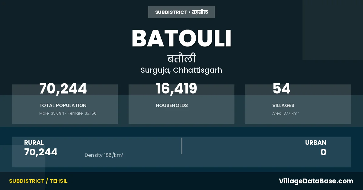
Batouli is a town and Tehsil in the Surguja district of the Chhattisgarh. In India, a Tehsil is a subdivision of a district responsible for the administration and revenue collection of a specific area within the district. Tehsils play a crucial role in the local governance structure, contributing significantly to the development and administration of their communities.
According to the 2011 census The total area of Batouli Tehsil is 377 km², with a population of 70244 people. The population density is 186 inhabitants per square kilometre, and there are approximately 16419 houses in the sub district.
Batouli Tehsil comprises about 54 villages. Below is a list of these villages along with information about their respective gram panchayats and the nearest town:
| # | Village Name | Gram Panchayat | Nearest Town |
|---|---|---|---|
| 1 | Baijnathpur | Birimkela | Sitapur (25 km) |
| 2 | Balampur | Balampur | Sitapur (10 km) |
| 3 | Bansajhal | Bansajhal | Ambikapur (50 km) |
| 4 | Basen | Basen | Sitapur (18 km) |
| 5 | Bataikela | Bataikela | Sitapur (12 km) |
| 6 | Batauli | Batauli | Sitapur (27 km) |
| 7 | Belkota | Belkota | Ambikapur (25 km) |
| 8 | Bhatko | Bhatko | Ambikapur (32 km) |
| 9 | Bilaspur | Bilaspur | Ambikapur (35 km) |
| 10 | Birimkela | Birimkela | Sitapur (23 km) |
| 11 | Boda | Boda | Ambikapur (40 km) |
| 12 | Chawarpani | Tirang | Ambikapur (48 km) |
| 13 | Chiparkaya | Chiparkaya | Sitapur (15 km) |
| 14 | Chiranga | Chiranga | Ambikapur (30 km) |
| 15 | Deori | Deori | Sitapur (29 km) |
| 16 | Dumarbhawana | Balampur | Sitapur (10 km) |
| 17 | Gahila | Gahila | Ambikapur (27 km) |
| 18 | Ghoghra | Ghoghara | Ambikapur (35 km) |
| 19 | Ghutrapara | Ghutrapara | Ambikapur (40 km) |
| 20 | Govindpur | Govindpur | Sitapur (23 km) |
| 21 | Jarhadih | Tarani | Sitapur (35 km) |
| 22 | Jhargawan | Jhargaon | Ambikapur (28 km) |
| 23 | Kachhardih | Salehadih | Ambikapur (42 km) |
| 24 | Kalipur | Manja | Ambikapur (30 km) |
| 25 | Kapatbahari | Kapathbahari | Sitapur (14 km) |
| 26 | Kardana | Kardana | Ambikapur (42 km) |
| 27 | Khaddhuwa | Khaddhowa | Ambikapur (31 km) |
| 28 | Kudkel | Salehadih | Ambikapur (42 km) |
| 29 | Kunkuri Kalan | Kunkuri | Sitapur (23 km) |
| 30 | Laigu | Kardana | Ambikapur (45 km) |
| 31 | Lalati | Lalati | Ambikapur (45 km) |
| 32 | Maheshpur | Maheshpur | Sitapur (15 km) |
| 33 | Mangari | Mangari | Sitapur (12 km) |
| 34 | Manja | Manja | Ambikapur (30 km) |
| 35 | Manpur | Manpur | Ambikapur (28 km) |
| 36 | Nakna | Nakna | Sitapur (17 km) |
| 37 | Naya Bandh | Birimkela | Sitapur (25 km) |
| 38 | Paprenga | Silma | Ambikapur (35 km) |
| 39 | Pathrai | Basen | Sitapur (18 km) |
| 40 | Poksari | Poksari | Sitapur (16 km) |
| 41 | Ratanpur | Vishnupur | Sitapur (17 km) |
| 42 | Salyadih | Salehadih | Ambikapur (40 km) |
| 43 | Saraswatipur | Basen | Sitapur (19 km) |
| 44 | Sarmana | Sarmana | Sitapur (30 km) |
| 45 | Sedam | Sedam | Sitapur (18 km) |
| 46 | Selma | Silma | Ambikapur (33 km) |
| 47 | Shivpur | Shivpur | Ambikapur (35 km) |
| 48 | Suarpara | Suwarpara | Sitapur (16 km) |
| 49 | Taragi | Tarani | Sitapur (35 km) |
| 50 | Tedga | Tedga | Ambikapur (35 km) |
| 51 | Telaidhar | Telaidhar | Sitapur (9 km) |
| 52 | Tirang | Tirang | Ambikapur (50 km) |
| 53 | Umapur | Jhargaon | Ambikapur (28 km) |
| 54 | Vishunpur | Vishnupur | Sitapur (7 km) |
The population is distributed between urban and rural areas as follows:
| Particulars | Rural | Urban | Total |
|---|---|---|---|
| Total Population | 70244 | 0 | 70244 |
| Male Population | 35094 | 0 | 35094 |
| Female Population | 35150 | 0 | 35150 | Population Density | 186 / km² | 186 / km² |
The distribution of households in the Batouli is:
| Rural Households | Urban Households | Total Households |
|---|---|---|
| 16419 | 0 | 16419 |
Q: What is Batouli?
A: Batouli is a town and in the Surguja district of the Chhattisgarh.
Q: What is the total area of Batouli Tehsil?
A: The total area of Batouli Tehsil is 377 km².
Q: What is the population of Batouli Tehsil according to the 2011 census?
A: According to the 2011 census, the population of Batouli Tehsil is 70244.
Q: What is the population density of Batouli Tehsil?
A: The population density of Batouli Tehsil is 186 inhabitants per square kilometre.
Q: How many houses are there in Batouli Tehsil?
A: There are approximately 16419 houses in Batouli Tehsil.
Q: How many villages are there in Batouli Tehsil?
A: There are about 54 villages in Batouli Tehsil.
Q: Which is the largest village by population in Batouli Tehsil?
A: The largest village by population in Batouli Tehsil is Poksari, with 3216 people.
Q: Which is the smallest village by population in Batouli Tehsil?
A: The smallest village by population in Batouli Tehsil is Baijnathpur, with 111 people.
Q: Which is the largest village by area in Batouli Tehsil?
A: The largest village by area in Batouli Tehsil is Chiparkaya, with 1293 km².
Q: Which is the smallest village by area in Batouli Tehsil?
A: The smallest village by area in Batouli Tehsil is Manja, with 24 km².
Q: What is the population distribution between urban and rural areas in Batouli Tehsil?
A: The population distribution in Batouli Tehsil is entirely rural, with a total rural population of 70244.
Q: What is the male population of Batouli Tehsil?
A: The male population of Batouli Tehsil is 35094.
Q: What is the female population of Batouli Tehsil?
A: The female population of Batouli Tehsil is 35150.
Q: How is the household distribution in Batouli Tehsil?
A: The household distribution in Batouli Tehsil is entirely rural, with a total of 16419 households.
Q: How many villages in Batouli Tehsil have a population between 100 and 499?
A: There are 4 villages in Batouli Tehsil with a population between 100 and 499.
Q: How many villages in Batouli Tehsil have a population between 500 and 999?
A: There are 16 villages in Batouli Tehsil with a population between 500 and 999.
Q: How many villages in Batouli Tehsil have a population between 1000 and 1999?
A: There are 26 villages in Batouli Tehsil with a population between 1000 and 1999.
Q: How many villages in Batouli Tehsil have a population between 2000 and 2999?
A: There is 7 village in Batouli Tehsil with a population between 2000 and 2999.
Q: How many villages in Batouli Tehsil have a population between 3000 and 3999?
A: There is 1 village in Batouli Tehsil with a population between 3000 and 3999.
| Total Population | Villages in Sub District Of Batouli |
|---|---|
| 100-499 | 4 |
| 500-999 | 16 |
| 1000-1999 | 26 |
| 2000-2999 | 7 |
| 3000-3999 | 1 |