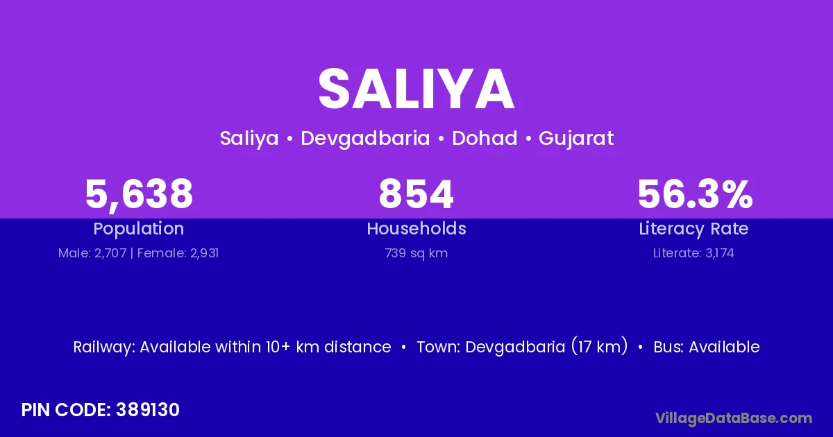
Saliya village is located in the Devgadbaria Taluka of the Dohad district in Gujarat .
Block / Taluka → Devgadbaria
District → Dohad
State → Gujarat
According to Census 2011 information, the village code of Saliya village is 389130.
Saliya village has a total population of 5,638 people, of which 2,707 are males and 2,931 are females.
The literacy rate of Saliya village is 56.30%. Male literacy stands at 70.34% and female literacy at 43.33%.
There are approximately 854 households in Saliya village.
Devgadbaria (17 km) is the nearest town to Saliya village for major economic activities and is located approximately 17 km away.
The population of Saliya village is distributed between literate and illiterate residents as follows:
| Particulars | Male | Female | Total |
|---|---|---|---|
| Literate | 1,904 | 1,270 | 3,174 |
| Illiterate | 803 | 1,661 | 2,464 |
| Total | 2,707 | 2,931 | 5,638 |
Source: Census 2011
| Village | District |
|---|---|
| Asayadi | Dohad |
| Bhathwada | Dohad |
| Gamdi | Ahmadabad |
| Gamdi | Anand |
| Gamdi | Banas Kantha |
| Gamdi | Dohad |
| Gamdi | Dohad |
| Gamdi | Panch Mahals |
| Gamdi | Sabar Kantha |
| Gamdi | Tapi |
| Gamdi | Vadodara |
| Gamdi | Jhabua |
| Guna | Bilaspur |
| Guna | Dohad |
| Guna | Katni |
| Guna | Tikamgarh |
| Guna | Karauli |
| Panchela | Dohad |
| Toyani | Dohad |
| Toyani | Dohad |
| Vadodar | Dohad |
| Vadodar | Panch Mahals |
| Vadodar | Rajkot |
No reviews yet. Be the first to review this village!
Available within 10+ km distance
Available within village
Available within 10+ km distance