District → Gandhinagar
State → Gujarat
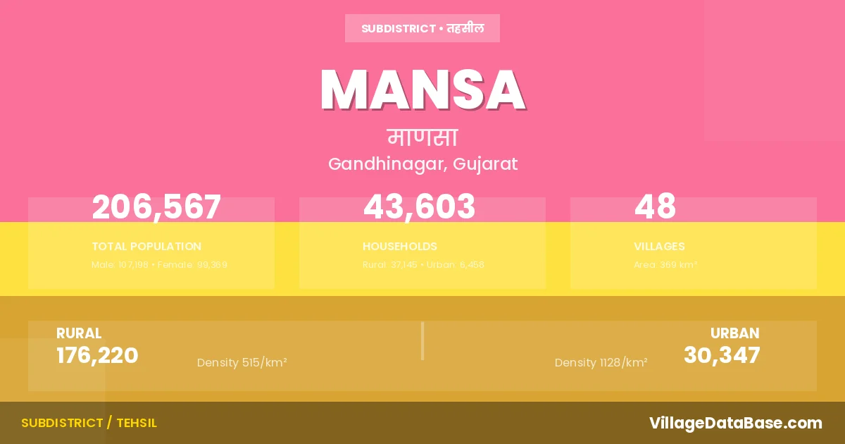
Mansa is a town and Taluka in the Gandhinagar district of the Gujarat. In India, a Taluka is a subdivision of a district responsible for the administration and revenue collection of a specific area within the district. Talukas play a crucial role in the local governance structure, contributing significantly to the development and administration of their communities.
According to the 2011 census The total area of Mansa Taluka is 369 km², with a population of 206567 people. The population density is 560 inhabitants per square kilometre, and there are approximately 43603 houses in the sub district.
Mansa Taluka comprises about 48 villages. Below is a list of these villages along with information about their respective gram panchayats and the nearest town:
| # | Village Name | Gram Panchayat | Nearest Town |
|---|---|---|---|
| 1 | Ajol | Ajol | Mansa (8 km) |
| 2 | Amarapur | Amarapur | Mansa (14 km) |
| 3 | Amarpura | Amarpura Kh | Mansa (10 km) |
| 4 | Ambod | Ambod | Mansa (7 km) |
| 5 | Anodiya | Anodiya | Mansa (28 km) |
| 6 | Badpura | Badpura | Mansa (11 km) |
| 7 | Bapupura | Bapupura | Mansa (5 km) |
| 8 | Bhimpura | Bhimpura M | Mansa (5 km) |
| 9 | Bilodra | Bilodra | Mansa (12 km) |
| 10 | Boru | Boru | Mansa (10 km) |
| 11 | Chadasana | Chadasna | Vijapur (10 km) |
| 12 | Charada | Charada | Mansa (8 km) |
| 13 | Delvad | Delvad | Mansa (12 km) |
| 14 | Delvada | Delvada | Mansa (11 km) |
| 15 | Dhameda | Dhameda | Mansa (5 km) |
| 16 | Dholakuva | Dholakuva | Mansa (4 km) |
| 17 | Fatehpura | Fatehpura | Mansa (2 km) |
| 18 | Galthara | Galthara | Mansa (6 km) |
| 19 | Gulabpura | Gulabpura | Mansa (3 km) |
| 20 | Gunma | Mansa (17 km) | |
| 21 | Harnahoda | Harna Hoda | Mansa (17 km) |
| 22 | Indrapura | Indrapura | Mansa (4 km) |
| 23 | Itadara | Itadra | Mansa (5 km) |
| 24 | Khadat | Khadat | Vijapur (7 km) |
| 25 | Kharna | Kharna | Mansa (9 km) |
| 26 | Khata Amba | Khata Aamba | Mansa (12 km) |
| 27 | Kuvadara | Kunvadara | Mansa (12 km) |
| 28 | Lakroda | Lakroda | Mansa (23 km) |
| 29 | Lodra | Lodra | Mansa (9 km) |
| 30 | Mahudi | Mahudi | Mansa (14 km) |
| 31 | Mandali | Mandali V | Mansa (12 km) |
| 32 | Manekpur Makakhad | Manekpura Makakhad | Mansa (4 km) |
| 33 | Padusma | Padusma | Mansa (10 km) |
| 34 | Paldi Rathod | Paladi Rathod | Mansa (12 km) |
| 35 | Paldi Vyas | Paladi Vyas | Vijapur (11 km) |
| 36 | Parbatpura | Parbatpura | Mansa (5 km) |
| 37 | Parsa | Parsa | Mansa (5 km) |
| 38 | Patanpura | Patanpura | Mansa (30 km) |
| 39 | Pundhara | Pundhara | Vijapur (9 km) |
| 40 | Rajpura | Rajpura | Mansa (5 km) |
| 41 | Rampura | Rampura | Mansa (3 km) |
| 42 | Rangpur | Rangpur | Mansa (20 km) |
| 43 | Ridrol | Ridrol | Mansa (5 km) |
| 44 | Samou | Samou | Mansa (12 km) |
| 45 | Solaiya | Solaiya | Mansa (5 km) |
| 46 | Varsoda | Varsoda | Mansa (14 km) |
| 47 | Veda | Veda | Vijapur (7 km) |
| 48 | Vihar | Vihar | Mansa (13 km) |
The population is distributed between urban and rural areas as follows:
| Particulars | Rural | Urban | Total |
|---|---|---|---|
| Total Population | 176220 | 30347 | 206567 |
| Male Population | 91101 | 16097 | 107198 |
| Female Population | 85119 | 14250 | 99369 | Population Density | 515 / km² | 1128 / km² | 560 / km² |
The distribution of households in the Mansa is:
| Rural Households | Urban Households | Total Households |
|---|---|---|
| 37145 | 6458 | 43603 |
Q: What is Mansa?
A: Mansa is a town and in the Gandhinagar district of the Gujarat.
Q: What is the total area of Mansa Taluka?
A: The total area of Mansa Taluka is 369 km².
Q: What is the population of Mansa Taluka according to the 2011 census?
A: According to the 2011 census, the population of Mansa Taluka is 206567.
Q: What is the population density of Mansa Taluka?
A: The population density of Mansa Taluka is 560 inhabitants per square kilometre.
Q: How many houses are there in Mansa Taluka?
A: There are approximately 43603 houses in Mansa Taluka.
Q: How many villages are there in Mansa Taluka?
A: There are about 48 villages in Mansa Taluka.
Q: Which is the largest village by population in Mansa Taluka?
A: The largest village by population in Mansa Taluka is Charada, with 10595 people.
Q: Which is the smallest village by population in Mansa Taluka?
A: The smallest village by population in Mansa Taluka is Gunma, with 554 people.
Q: Which is the largest village by area in Mansa Taluka?
A: The largest village by area in Mansa Taluka is Anodiya, with 1980 km².
Q: Which is the smallest village by area in Mansa Taluka?
A: The smallest village by area in Mansa Taluka is Rajpura, with 104 km².
Q: What is the male population of Mansa Taluka?
A: The male population of Mansa Taluka is 107198.
Q: What is the female population of Mansa Taluka?
A: The female population of Mansa Taluka is 99369.
Q: How many villages in Mansa Taluka have a population between 500 and 999?
A: There are 3 villages in Mansa Taluka with a population between 500 and 999.
Q: How many villages in Mansa Taluka have a population between 1000 and 1999?
A: There are 9 villages in Mansa Taluka with a population between 1000 and 1999.
Q: How many villages in Mansa Taluka have a population between 2000 and 2999?
A: There is 10 village in Mansa Taluka with a population between 2000 and 2999.
Q: How many villages in Mansa Taluka have a population between 3000 and 3999?
A: There is 10 village in Mansa Taluka with a population between 3000 and 3999.
Q: How many villages in Mansa Taluka have a population between 4000 and 4999?
A: There is 3 village in Mansa Taluka with a population between 4000 and 4999.
Q: How many villages in Mansa Taluka have a population of 5000 and above?
A: There is 13 village in Mansa Taluka with a population of 5000 and above.
| Total Population | Villages in Sub District Of Mansa |
|---|---|
| 500-999 | 3 |
| 1000-1999 | 9 |
| 2000-2999 | 10 |
| 3000-3999 | 10 |
| 4000-4999 | 3 |
| 5000 And Above | 13 |