Satlasana: A Town and Taluka in Mahesana district
District → Mahesana
State → Gujarat
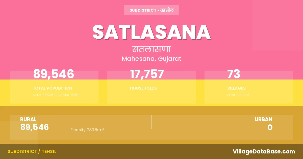
Satlasana is a town and Taluka in the Mahesana district of the Gujarat. In India, a Taluka is a subdivision of a district responsible for the administration and revenue collection of a specific area within the district. Talukas play a crucial role in the local governance structure, contributing significantly to the development and administration of their communities.
According to the 2011 census The total area of Satlasana Taluka is 310 km², with a population of 89546 people. The population density is 289 inhabitants per square kilometre, and there are approximately 17757 houses in the sub district.
Satlasana Taluka comprises about 73 villages. Below is a list of these villages along with information about their respective gram panchayats and the nearest town:
| # | Village Name | Gram Panchayat | Nearest Town |
|---|---|---|---|
| 1 | Ajabapur | Kheralu (30 km) | |
| 2 | Anand Bhankhari | Isakpura | Kheralu (12 km) |
| 3 | Ankaliyara | Ankaliyara | Kheralu (18 km) |
| 4 | Bedasma | Bedasma | Kheralu (30 km) |
| 5 | Bhalu Moti | Moti Bhalu | Kheralu (29 km) |
| 6 | Bhalu Nani | Nani Bhalu | Kheralu (29 km) |
| 7 | Bhalusana | Bhalusana | Kheralu (30 km) |
| 8 | Bhanavas | Bhanavas | Kheralu (27 km) |
| 9 | Bhatvas | Umrecha | Kheralu (23 km) |
| 10 | Bhimpur | Bhimpur | Kheralu (20 km) |
| 11 | Chelana | Chelana | Kheralu (23 km) |
| 12 | Chhelpura | Dharavania | Kheralu (40 km) |
| 13 | Dhadhivas | Kheralu (37 km) | |
| 14 | Dharavania | Dharavania | Kheralu (40 km) |
| 15 | Dharoi | Dharoi | Kheralu (32 km) |
| 16 | Dulana | Sardarpur Chi | Kheralu (10 km) |
| 17 | Fatepura | Fatepura | Kheralu (40 km) |
| 18 | Galalpur | Otalpur | Kheralu (20 km) |
| 19 | Gamanpur | Kheralu (40 km) | |
| 20 | Gamanpura | Dharavania | Kheralu (37 km) |
| 21 | Gothda | Gothda | Kheralu (27 km) |
| 22 | Hadol | Hadol | Kheralu (24 km) |
| 23 | Himmatpura | Umrecha | Kheralu (24 km) |
| 24 | Isakpura | Isakpura | Kheralu (11 km) |
| 25 | Jashpuriya | Vasai Jaspuriya | Visnagar (45 km) |
| 26 | Jaspur | Khilod | Kheralu (17 km) |
| 27 | Kajipur | Otalpur | Kheralu (20 km) |
| 28 | Kanediya | Kanediya | Kheralu (22 km) |
| 29 | Kesarpura | Sardarpur Chi | Kheralu (10 km) |
| 30 | Kevdasan | Malapura Kevdasan | Kheralu (26 km) |
| 31 | Khari | Ranpur | Kheralu (24 km) |
| 32 | Khilod | Khilod | Kheralu (22 km) |
| 33 | Khodamali | Khodamali | Kheralu (32 km) |
| 34 | Kothasana Mota | Mota Kothasana | Kheralu (34 km) |
| 35 | Kothasana Nana | Mota Kothasana | Kheralu (37 km) |
| 36 | Kubada | Kubada | Kheralu (25 km) |
| 37 | Malana | Kheralu (30 km) | |
| 38 | Malapura | Malapura Kevdasan | Kheralu (28 km) |
| 39 | Mumanvas | Mumanvas | Kheralu (32 km) |
| 40 | Navavas | Ankaliyara | Kheralu (22 km) |
| 41 | Nedardi | Nedardi | Kheralu (40 km) |
| 42 | Nijhampur | Khilod | Kheralu (18 km) |
| 43 | Otalpur | Otalpur | Kheralu (20 km) |
| 44 | Pirojpura | Khilod | Kheralu (22 km) |
| 45 | Rabarivas | Kheralu (36 km) | |
| 46 | Radhupura | Kanediya | Kheralu (24 km) |
| 47 | Rajpur | Ankaliyara | Kheralu (14 km) |
| 48 | Rangpur | Kanediya | Kheralu (20 km) |
| 49 | Ranpur | Ranpur | Kheralu (22 km) |
| 50 | Rinchhada | Khilod | Kheralu (21 km) |
| 51 | Sadrasan | Visnagar (45 km) | |
| 52 | Samarapur | Samarapur | Kheralu (36 km) |
| 53 | Santola | Kubada | Kheralu (46 km) |
| 54 | Sardarpur | Sardarpur Chi | Kheralu (15 km) |
| 55 | Sartanpur | Sartanpur Gadh | Visnagar (50 km) |
| 56 | Satlasana | Satlasana | Kheralu (25 km) |
| 57 | Semor | Nani Bhalu | Kheralu (31 km) |
| 58 | Shahupura | Isakpura | Kheralu (13 km) |
| 59 | Sheshhapur | Bhalusana | Kheralu (27 km) |
| 60 | Sudasana | Sudasana | Kheralu (20 km) |
| 61 | Takhatpura | Ranpur | Kheralu (20 km) |
| 62 | Talegadh | Talegadh | Kheralu (25 km) |
| 63 | Timba | Timba | Kheralu (24 km) |
| 64 | Umari | Umari | Kheralu (23 km) |
| 65 | Umrecha | Umrecha | Kheralu (22 km) |
| 66 | Vadnal | Kheralu (35 km) | |
| 67 | Vaghar | Vaghar | Kheralu (15 km) |
| 68 | Vaghva Mandva | Kheralu (27 km) | |
| 69 | Vajapur | Vajapur | Kheralu (36 km) |
| 70 | Vansada | Mota Kothasana | Kheralu (23 km) |
| 71 | Vasai | Vasai Jaspuriya | Visnagar (45 km) |
| 72 | Vav | Vav | Visnagar (50 km) |
| 73 | Vavadi | Khodamali | Kheralu (33 km) |
The population is distributed between urban and rural areas as follows:
| Particulars | Rural | Urban | Total |
|---|---|---|---|
| Total Population | 89546 | 0 | 89546 |
| Male Population | 46036 | 0 | 46036 |
| Female Population | 43510 | 0 | 43510 | Population Density | 289 / km² | 289 / km² |
The distribution of households in the Satlasana is:
| Rural Households | Urban Households | Total Households |
|---|---|---|
| 17757 | 0 | 17757 |
Q: What is Satlasana?
A: Satlasana is a town and in the Mahesana district of the Gujarat.
Q: What is the total area of Satlasana Taluka?
A: The total area of Satlasana Taluka is 310 km².
Q: What is the population of Satlasana Taluka according to the 2011 census?
A: According to the 2011 census, the population of Satlasana Taluka is 89546.
Q: What is the population density of Satlasana Taluka?
A: The population density of Satlasana Taluka is 289 inhabitants per square kilometre.
Q: How many houses are there in Satlasana Taluka?
A: There are approximately 17757 houses in Satlasana Taluka.
Q: How many villages are there in Satlasana Taluka?
A: There are about 73 villages in Satlasana Taluka.
Q: Which is the largest village by population in Satlasana Taluka?
A: The largest village by population in Satlasana Taluka is Satlasana, with 8002 people.
Q: Which is the smallest village by population in Satlasana Taluka?
A: The smallest village by population in Satlasana Taluka is Ajabapur, with 0 people.
Q: Which is the largest village by area in Satlasana Taluka?
A: The largest village by area in Satlasana Taluka is Timba, with 2877 km².
Q: Which is the smallest village by area in Satlasana Taluka?
A: The smallest village by area in Satlasana Taluka is Ajabapur, with 49 km².
Q: What is the population distribution between urban and rural areas in Satlasana Taluka?
A: The population distribution in Satlasana Taluka is entirely rural, with a total rural population of 89546.
Q: What is the male population of Satlasana Taluka?
A: The male population of Satlasana Taluka is 46036.
Q: What is the female population of Satlasana Taluka?
A: The female population of Satlasana Taluka is 43510.
Q: How is the household distribution in Satlasana Taluka?
A: The household distribution in Satlasana Taluka is entirely rural, with a total of 17757 households.
Q: How many villages in Satlasana Taluka have a population of less than 100?
A: There are 9 villages in Satlasana Taluka with a population of less than 100.
Q: How many villages in Satlasana Taluka have a population between 100 and 499?
A: There are 8 villages in Satlasana Taluka with a population between 100 and 499.
Q: How many villages in Satlasana Taluka have a population between 500 and 999?
A: There are 24 villages in Satlasana Taluka with a population between 500 and 999.
Q: How many villages in Satlasana Taluka have a population between 1000 and 1999?
A: There are 19 villages in Satlasana Taluka with a population between 1000 and 1999.
Q: How many villages in Satlasana Taluka have a population between 2000 and 2999?
A: There is 7 village in Satlasana Taluka with a population between 2000 and 2999.
Q: How many villages in Satlasana Taluka have a population between 3000 and 3999?
A: There is 4 village in Satlasana Taluka with a population between 3000 and 3999.
Q: How many villages in Satlasana Taluka have a population between 4000 and 4999?
A: There is 1 village in Satlasana Taluka with a population between 4000 and 4999.
Q: How many villages in Satlasana Taluka have a population of 5000 and above?
A: There is 1 village in Satlasana Taluka with a population of 5000 and above.
| Total Population | Villages in Sub District Of Satlasana |
|---|---|
| Less than 100 | 9 |
| 100-499 | 8 |
| 500-999 | 24 |
| 1000-1999 | 19 |
| 2000-2999 | 7 |
| 3000-3999 | 4 |
| 4000-4999 | 1 |
| 5000 And Above | 1 |