Dhansura: A Town and Taluka in Sabar Kantha district
District → Sabar Kantha
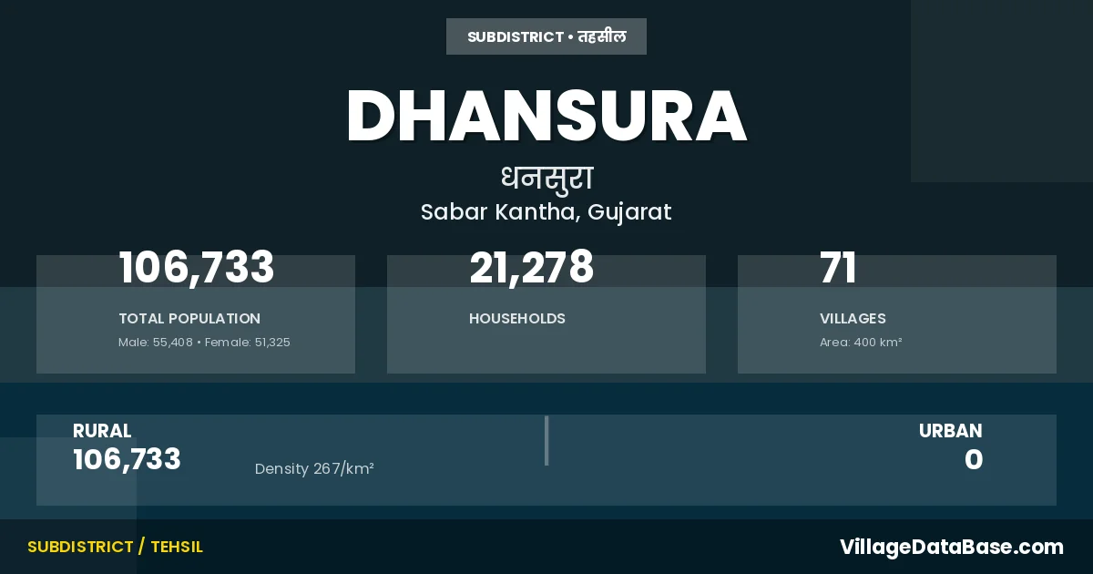
State → Gujarat
Dhansura is a town and Taluka in the Sabar Kantha district of the Gujarat. In India, a Taluka is a subdivision of a district responsible for the administration and revenue collection of a specific area within the district. Talukas play a crucial role in the local governance structure, contributing significantly to the development and administration of their communities.
According to the 2011 census The total area of Dhansura Taluka is 400 km², with a population of 106733 people. The population density is 267 inhabitants per square kilometre, and there are approximately 21278 houses in the sub district.
Dhansura Taluka comprises about 71 villages. Below is a list of these villages along with information about their respective gram panchayats and the nearest town:
| # | Village Name | Gram Panchayat | Nearest Town |
|---|---|---|---|
| 1 | Akrund | Akarund | Modasa (27 km) |
| 2 | Alva | Khilodiya | Modasa (25 km) |
| 3 | Amarpura | Udepur | Modasa (32 km) |
| 4 | Ambasar | Ambasar | Modasa (40 km) |
| 5 | Amodara | Amodara | Modasa (20 km) |
| 6 | Antisara | Sika | Modasa (13 km) |
| 7 | Barnoli | Barnoli | Modasa (27 km) |
| 8 | Bhensavada | Bhensavada | Modasa (12 km) |
| 9 | Bhotudev No Math | Dhamaniya | Modasa (27 km) |
| 10 | Bilvaniya | Bilvaniya | Modasa (28 km) |
| 11 | Borvai | Jamtha | Modasa (25 km) |
| 12 | Butal | Butal | Modasa (20 km) |
| 13 | Chhevadiya | Jaswantpura | Modasa (30 km) |
| 14 | Chogamda | Jaswantpura | Modasa (25 km) |
| 15 | Dhamaniya | Dhamaniya | Modasa (25 km) |
| 16 | Dhansura | Dhansura | Modasa (18 km) |
| 17 | Dolpur | Bhensavada | Modasa (20 km) |
| 18 | Gadhada Kot | Dhamaniya | Modasa (28 km) |
| 19 | Galalni Muvadi | Haripura Kampo | Modasa (34 km) |
| 20 | Gopalpura | Jaswantpura | Modasa (33 km) |
| 21 | Haripura Kampo | Haripura Kampo | Modasa (35 km) |
| 22 | Hirapur | Hirapur | Modasa (23 km) |
| 23 | Hirapur Kampo | Hirapur Kampo | Modasa (28 km) |
| 24 | Jalampur | Haripura Kampo | Modasa (19 km) |
| 25 | Jalampura | Kidi | Modasa (36 km) |
| 26 | Jamtha | Jamtha | Modasa (24 km) |
| 27 | Jashvantpura | Jaswantpura | Modasa (28 km) |
| 28 | Jitpur | Rajpur Vadagam | Modasa (29 km) |
| 29 | Kamli | Simli | Modasa (35 km) |
| 30 | Kanal | Jamtha | Modasa (25 km) |
| 31 | Kanjodiya | Jamtha | Modasa (20 km) |
| 32 | Karanpur | Bilvaniya | Modasa (30 km) |
| 33 | Karoli | Karoli | Modasa (27 km) |
| 34 | Kashipura | Kidi | Modasa (27 km) |
| 35 | Kesharpura | Bilvaniya | Modasa (28 km) |
| 36 | Kesharpura Kampo | Haripura Kampo | Modasa (35 km) |
| 37 | Khadol | Kolavada | Modasa (33 km) |
| 38 | Khanpurni Muvadi | Haripura Kampo | Modasa (35 km) |
| 39 | Kheda | Karoli | Modasa (28 km) |
| 40 | Khilodiya | Khilodiya | Modasa (32 km) |
| 41 | Kidi | Kidi | Modasa (18 km) |
| 42 | Kolavada | Kolavada | Modasa (9 km) |
| 43 | Lalino Math | Lalino Math | Modasa (30 km) |
| 44 | Lalpur | Kidi | Modasa (16 km) |
| 45 | Lalu | Udepur | Modasa (35 km) |
| 46 | Malekpur | Malekpur | Modasa (17 km) |
| 47 | Moti Vav | Rajpur Vadagam | Modasa (27 km) |
| 48 | Motipura | Jaswantpura | Modasa (34 km) |
| 49 | Nana | Haripura Kampo | Modasa (35 km) |
| 50 | Nani Vav | Rajpur Vadagam | Modasa (25 km) |
| 51 | Navalpur | Lalino Math | Modasa (30 km) |
| 52 | Panchkuhada | Hirapur | Modasa (23 km) |
| 53 | Patyo | Udepur | Modasa (38 km) |
| 54 | Poyda | Haripura Kampo | Modasa (30 km) |
| 55 | Rahiyol | Rahiyol | Modasa (10 km) |
| 56 | Rajpur | Rajpur Vadagam | Modasa (28 km) |
| 57 | Ramana | Ramana | Modasa (9 km) |
| 58 | Ramos | Ramos | Himatnagar (20 km) |
| 59 | Rampur | Lalino Math | Modasa (19 km) |
| 60 | Rampura | Lalino Math | Modasa (35 km) |
| 61 | Rampura Kampo | Udepur | Modasa (32 km) |
| 62 | Rupan | Ramana | Modasa (8 km) |
| 63 | Sardi Sarkhandi | Bilvaniya | Modasa (32 km) |
| 64 | Sengiyani Rayan | Jaswantpura | Modasa (28 km) |
| 65 | Shika | Vadagam | Modasa (12 km) |
| 66 | Shinol | Sinol | Modasa (13 km) |
| 67 | Simli | Simli | Modasa (35 km) |
| 68 | Udepur | Udepur | Modasa (35 km) |
| 69 | Vadagam | Vadagam | Modasa (25 km) |
| 70 | Vakhatpur | Lalino Math | Modasa (30 km) |
| 71 | Vantda Suka | Vantda Suka | Modasa (28 km) |
The population is distributed between urban and rural areas as follows:
| Particulars | Rural | Urban | Total |
|---|---|---|---|
| Total Population | 106733 | 0 | 106733 |
| Male Population | 55408 | 0 | 55408 |
| Female Population | 51325 | 0 | 51325 | Population Density | 267 / km² | 267 / km² |
The distribution of households in the Dhansura is:
| Rural Households | Urban Households | Total Households |
|---|---|---|
| 21278 | 0 | 21278 |
Q: What is Dhansura?
A: Dhansura is a town and in the Sabar Kantha district of the Gujarat.
Q: What is the total area of Dhansura Taluka?
A: The total area of Dhansura Taluka is 400 km².
Q: What is the population of Dhansura Taluka according to the 2011 census?
A: According to the 2011 census, the population of Dhansura Taluka is 106733.
Q: What is the population density of Dhansura Taluka?
A: The population density of Dhansura Taluka is 267 inhabitants per square kilometre.
Q: How many houses are there in Dhansura Taluka?
A: There are approximately 21278 houses in Dhansura Taluka.
Q: How many villages are there in Dhansura Taluka?
A: There are about 71 villages in Dhansura Taluka.
Q: Which is the largest village by population in Dhansura Taluka?
A: The largest village by population in Dhansura Taluka is Dhansura, with 12424 people.
Q: Which is the smallest village by population in Dhansura Taluka?
A: The smallest village by population in Dhansura Taluka is Haripura Kampo, with 117 people.
Q: Which is the largest village by area in Dhansura Taluka?
A: The largest village by area in Dhansura Taluka is Dhansura, with 3130 km².
Q: Which is the smallest village by area in Dhansura Taluka?
A: The smallest village by area in Dhansura Taluka is Sengiyani Rayan, with 71 km².
Q: What is the population distribution between urban and rural areas in Dhansura Taluka?
A: The population distribution in Dhansura Taluka is entirely rural, with a total rural population of 106733.
Q: What is the male population of Dhansura Taluka?
A: The male population of Dhansura Taluka is 55408.
Q: What is the female population of Dhansura Taluka?
A: The female population of Dhansura Taluka is 51325.
Q: How is the household distribution in Dhansura Taluka?
A: The household distribution in Dhansura Taluka is entirely rural, with a total of 21278 households.
Q: How many villages in Dhansura Taluka have a population between 100 and 499?
A: There are 19 villages in Dhansura Taluka with a population between 100 and 499.
Q: How many villages in Dhansura Taluka have a population between 500 and 999?
A: There are 20 villages in Dhansura Taluka with a population between 500 and 999.
Q: How many villages in Dhansura Taluka have a population between 1000 and 1999?
A: There are 18 villages in Dhansura Taluka with a population between 1000 and 1999.
Q: How many villages in Dhansura Taluka have a population between 2000 and 2999?
A: There is 7 village in Dhansura Taluka with a population between 2000 and 2999.
Q: How many villages in Dhansura Taluka have a population between 3000 and 3999?
A: There is 1 village in Dhansura Taluka with a population between 3000 and 3999.
Q: How many villages in Dhansura Taluka have a population between 4000 and 4999?
A: There is 3 village in Dhansura Taluka with a population between 4000 and 4999.
Q: How many villages in Dhansura Taluka have a population of 5000 and above?
A: There is 3 village in Dhansura Taluka with a population of 5000 and above.
| Total Population | Villages in Sub District Of Dhansura |
|---|---|
| 100-499 | 19 |
| 500-999 | 20 |
| 1000-1999 | 18 |
| 2000-2999 | 7 |
| 3000-3999 | 1 |
| 4000-4999 | 3 |
| 5000 And Above | 3 |