District → Surat
State → Gujarat
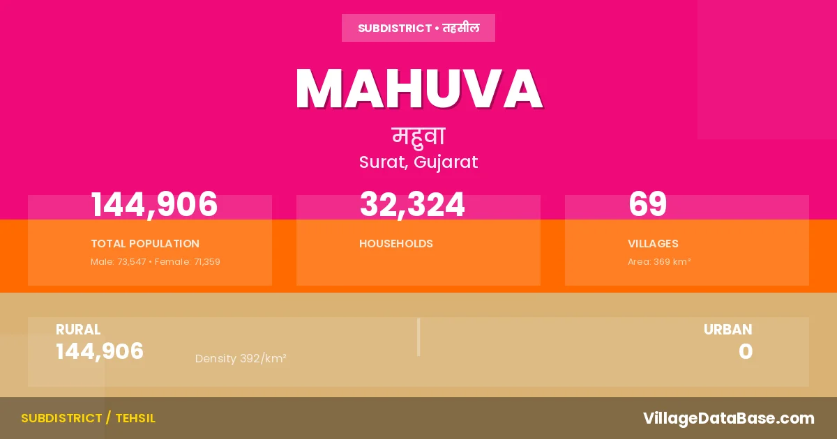
Mahuva is a town and Taluka in the Surat district of the Gujarat. In India, a Taluka is a subdivision of a district responsible for the administration and revenue collection of a specific area within the district. Talukas play a crucial role in the local governance structure, contributing significantly to the development and administration of their communities.
According to the 2011 census The total area of Mahuva Taluka is 369 km², with a population of 144906 people. The population density is 392 inhabitants per square kilometre, and there are approximately 32324 houses in the sub district.
Mahuva Taluka comprises about 69 villages. Below is a list of these villages along with information about their respective gram panchayats and the nearest town:
| # | Village Name | Gram Panchayat | Nearest Town |
|---|---|---|---|
| 1 | Algat | Algat | Bardoli (27 km) |
| 2 | Amchak | Amchak | Bardoli (17 km) |
| 3 | Amroli | Amroli | Bardoli (17 km) |
| 4 | Anaval | Anaval | Bardoli (42 km) |
| 5 | Andhatri | Andhatri | Bardoli (20 km) |
| 6 | Angaldhara | Angaldhara | Bardoli (45 km) |
| 7 | Bamaniya | Bamaniya | Bardoli (30 km) |
| 8 | Bartad | Bartad | Bardoli (23 km) |
| 9 | Bhoriya | Bhoriya | Bardoli (32 km) |
| 10 | Bilkhadi | Bilkhadi | Bardoli (23 km) |
| 11 | Boriya | Boriya | Bardoli (14 km) |
| 12 | Budhleshvar | Miyapur | Bardoli (14 km) |
| 13 | Butvada | Butvada | Bardoli (26 km) |
| 14 | Dedvasan | Dedvasan | Navsari (17 km) |
| 15 | Dhamkhadi | Dhamkhadi | Bardoli (35 km) |
| 16 | Dholikui | Dholikui | Navsari (18 km) |
| 17 | Dhundhesa | Mahuva | Bardoli (15 km) |
| 18 | Dungari | Dungari | Bardoli (24 km) |
| 19 | Fulvadi | Fulvadi | Navsari (18 km) |
| 20 | Gangadiya | Gangadiya | Navsari (40 km) |
| 21 | Ghadoi | Ghadoi | Navsari (17 km) |
| 22 | Gopla | Gopla | Navsari (20 km) |
| 23 | Gunasvel | Gunasvel | Bardoli (29 km) |
| 24 | Haladva | Haladhava | Bardoli (26 km) |
| 25 | Jhervavra | Jhervavra | Navsari (14 km) |
| 26 | Jol | Jol | Bardoli (12 km) |
| 27 | Kachhal | Kachhal | Bardoli (17 km) |
| 28 | Kadhaiya | Kadhaiya | Bardoli (24 km) |
| 29 | Kadiya | Miyapur | Bardoli (15 km) |
| 30 | Kani | Kani | Bardoli (11 km) |
| 31 | Kankariya | Kankariya | Bardoli (37 km) |
| 32 | Karcheliya | Karcheliya | Bardoli (20 km) |
| 33 | Kavitha | Kavitha | Bardoli (18 km) |
| 34 | Khandal | Bartad | Bardoli (22 km) |
| 35 | Kharvan | Kharvan | Bardoli (22 km) |
| 36 | Kodada | Kodada | Bardoli (16 km) |
| 37 | Kos | Kos | Bardoli (44 km) |
| 38 | Kumkotar | Kumkotar | Bardoli (42 km) |
| 39 | Lasanpor | Lasanpor | Bardoli (42 km) |
| 40 | Machhisadada | Machhisadada | Bardoli (35 km) |
| 41 | Mahudi | Boriya | Bardoli (16 km) |
| 42 | Mahuva | Mahuva | Bardoli (12 km) |
| 43 | Mahuvariya | Mahuvariya | Bardoli (42 km) |
| 44 | Miyapur | Miyapur | Bardoli (12 km) |
| 45 | Mudat | Mudat | Bardoli (19 km) |
| 46 | Naldhara | Naldhara | Bardoli (20 km) |
| 47 | Narda | Narda | Bardoli (19 km) |
| 48 | Nihali | Nihali | Navsari (17 km) |
| 49 | Ondach | Ondach | Bardoli (12 km) |
| 50 | Pathron | Pathron | Bardoli (8 km) |
| 51 | Puna | Puna | Bardoli (26 km) |
| 52 | Ranat | Ranat | Bardoli (15 km) |
| 53 | Samba | Sanvalla | Bardoli (39 km) |
| 54 | Sanvalla | Sanvalla | Bardoli (31 km) |
| 55 | Sevasan | Kavitha | Bardoli (19 km) |
| 56 | Shankar Talavdi | Mahuva | Bardoli (14 km) |
| 57 | Shekhpur | Shekhpur | Bardoli (17 km) |
| 58 | Tarkani | Tarkani | Bardoli (39 km) |
| 59 | Tarsadi | Tarsadi | Bardoli (6 km) |
| 60 | Umra | Umra | Bardoli (34 km) |
| 61 | Vachhavad | Vachhavad | Bardoli (22 km) |
| 62 | Vadiya | Vadiya | Bardoli (20 km) |
| 63 | Vagheshvar | Vagheshvar | Navsari (17 km) |
| 64 | Vaheval | Vaheval | Bardoli (35 km) |
| 65 | Valvada | Valvada | Bardoli (32 km) |
| 66 | Vank | Vank | Bardoli (24 km) |
| 67 | Vanskui | Vanskui | Bardoli (23 km) |
| 68 | Vasrai | Vasrai | Bardoli (24 km) |
| 69 | Velanpur | Velanpur | Bardoli (29 km) |
The population is distributed between urban and rural areas as follows:
| Particulars | Rural | Urban | Total |
|---|---|---|---|
| Total Population | 144906 | 0 | 144906 |
| Male Population | 73547 | 0 | 73547 |
| Female Population | 71359 | 0 | 71359 | Population Density | 392 / km² | 392 / km² |
The distribution of households in the Mahuva is:
| Rural Households | Urban Households | Total Households |
|---|---|---|
| 32324 | 0 | 32324 |
Q: What is Mahuva?
A: Mahuva is a town and in the Surat district of the Gujarat.
Q: What is the total area of Mahuva Taluka?
A: The total area of Mahuva Taluka is 369 km².
Q: What is the population of Mahuva Taluka according to the 2011 census?
A: According to the 2011 census, the population of Mahuva Taluka is 144906.
Q: What is the population density of Mahuva Taluka?
A: The population density of Mahuva Taluka is 392 inhabitants per square kilometre.
Q: How many houses are there in Mahuva Taluka?
A: There are approximately 32324 houses in Mahuva Taluka.
Q: How many villages are there in Mahuva Taluka?
A: There are about 69 villages in Mahuva Taluka.
Q: Which is the largest village by population in Mahuva Taluka?
A: The largest village by population in Mahuva Taluka is Anaval, with 6722 people.
Q: Which is the smallest village by population in Mahuva Taluka?
A: The smallest village by population in Mahuva Taluka is Khandal, with 215 people.
Q: Which is the largest village by area in Mahuva Taluka?
A: The largest village by area in Mahuva Taluka is Umra, with 1616 km².
Q: Which is the smallest village by area in Mahuva Taluka?
A: The smallest village by area in Mahuva Taluka is Kadiya, with 131 km².
Q: What is the population distribution between urban and rural areas in Mahuva Taluka?
A: The population distribution in Mahuva Taluka is entirely rural, with a total rural population of 144906.
Q: What is the male population of Mahuva Taluka?
A: The male population of Mahuva Taluka is 73547.
Q: What is the female population of Mahuva Taluka?
A: The female population of Mahuva Taluka is 71359.
Q: How is the household distribution in Mahuva Taluka?
A: The household distribution in Mahuva Taluka is entirely rural, with a total of 32324 households.
Q: How many villages in Mahuva Taluka have a population between 100 and 499?
A: There are 7 villages in Mahuva Taluka with a population between 100 and 499.
Q: How many villages in Mahuva Taluka have a population between 500 and 999?
A: There are 12 villages in Mahuva Taluka with a population between 500 and 999.
Q: How many villages in Mahuva Taluka have a population between 1000 and 1999?
A: There are 19 villages in Mahuva Taluka with a population between 1000 and 1999.
Q: How many villages in Mahuva Taluka have a population between 2000 and 2999?
A: There is 18 village in Mahuva Taluka with a population between 2000 and 2999.
Q: How many villages in Mahuva Taluka have a population between 3000 and 3999?
A: There is 4 village in Mahuva Taluka with a population between 3000 and 3999.
Q: How many villages in Mahuva Taluka have a population between 4000 and 4999?
A: There is 3 village in Mahuva Taluka with a population between 4000 and 4999.
Q: How many villages in Mahuva Taluka have a population of 5000 and above?
A: There is 6 village in Mahuva Taluka with a population of 5000 and above.
| Total Population | Villages in Sub District Of Mahuva |
|---|---|
| 100-499 | 7 |
| 500-999 | 12 |
| 1000-1999 | 19 |
| 2000-2999 | 18 |
| 3000-3999 | 4 |
| 4000-4999 | 3 |
| 5000 And Above | 6 |