District → Surat
State → Gujarat
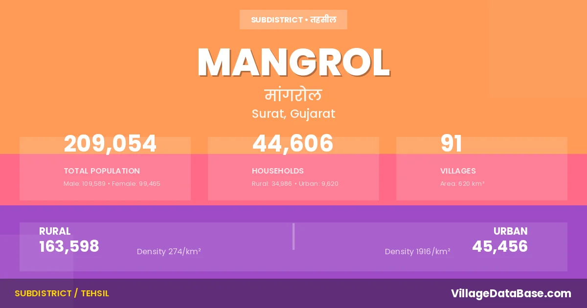
Mangrol is a town and Taluka in the Surat district of the Gujarat. In India, a Taluka is a subdivision of a district responsible for the administration and revenue collection of a specific area within the district. Talukas play a crucial role in the local governance structure, contributing significantly to the development and administration of their communities.
According to the 2011 census The total area of Mangrol Taluka is 620 km², with a population of 209054 people. The population density is 337 inhabitants per square kilometre, and there are approximately 44606 houses in the sub district.
Mangrol Taluka comprises about 91 villages. Below is a list of these villages along with information about their respective gram panchayats and the nearest town:
| # | Village Name | Gram Panchayat | Nearest Town |
|---|---|---|---|
| 1 | Amarkui | Kantvav | Surat (78 km) |
| 2 | Ambavadi | Ambavadi | Surat (65 km) |
| 3 | Amkhuta | Amkhuta | Kosamba (35 km) |
| 4 | Amnedara | Amnedara | Kosamba (15 km) |
| 5 | Ankdod | Ankdod | Mangrol (6 km) |
| 6 | Ansodala | Limbada | Kosamba (10 km) |
| 7 | Asarma | Asarma | Ankleshvar (32 km) |
| 8 | Bhadkuva | Bhadkuva | Tarsadi (42 km) |
| 9 | Bhatkol | Lindiad | Kim (4 km) |
| 10 | Bhilvada | Bhilvada | Mangrol (7 km) |
| 11 | Boria | Boria | Kosamba (25 km) |
| 12 | Boridara | Boridara | Tarsadi (12 km) |
| 13 | Borsad | Borsad | Kim (25 km) |
| 14 | Charetha | Shah | Kosamba (20 km) |
| 15 | Chhamuchhal | Molvan | Kim (12 km) |
| 16 | Dhamdod | Dhamdod | Tarsadi (10 km) |
| 17 | Dholikui | Dholikui | Kosamba (35 km) |
| 18 | Dinod | Dinod | Tarsadi (12 km) |
| 19 | Dungri | Dungri | Kim (27 km) |
| 20 | Gadkachh | Mangrol | Surat (70 km) |
| 21 | Ghodbar | Ghodbar | Mandvi (22 km) |
| 22 | Ghunti | Limbada | Kosamba (23 km) |
| 23 | Gijram | Gijram | Mangrol (6 km) |
| 24 | Harsani | Harsani | Mangrol (5 km) |
| 25 | Hathoda | Hathoda | Kosamba (5 km) |
| 26 | Hathuran | Hathuran | Kosamba (2 km) |
| 27 | Isanpur | Isanpur | Surat (80 km) |
| 28 | Jhankharda | Jhankharda | Surat (50 km) |
| 29 | Jhankhvav | Jhankhvav | Kosamba (35 km) |
| 30 | Jharni | Vankal | Surat (80 km) |
| 31 | Jhinora | Dholikui | Kosamba (15 km) |
| 32 | Kansali | Kansali | Kosamba (19 km) |
| 33 | Kantva | Kantva | Kosamba (22 km) |
| 34 | Kantvav | Kantvav | Surat (75 km) |
| 35 | Kanvada | Kosadi | Kosamba (22 km) |
| 36 | Kargara | Harsani | Surat (80 km) |
| 37 | Kathvada | Kathvada | Kosamba (5 km) |
| 38 | Kevdi | Isanpur | Surat (75 km) |
| 39 | Khareda | Khareda | Surat (80 km) |
| 40 | Kosadi | Kosadi | Kosamba (20 km) |
| 41 | Kosamba | Mangrol | |
| 42 | Kothva | Kothva | Surat (40 km) |
| 43 | Kumvarda | Kuvarda | Kosamba (3 km) |
| 44 | Lavet | Lavet | Kosamba (35 km) |
| 45 | Limbada | Limbada | Kosamba (15 km) |
| 46 | Limodara | Limodara | Kim (12 km) |
| 47 | Lindiad | Lindiad | Surat (40 km) |
| 48 | Luvara | Luvara | Kosamba (20 km) |
| 49 | Mahuej | Mahuej | Bharuch (30 km) |
| 50 | Mandan | Mandan Boria | Surat (85 km) |
| 51 | Mangrol | Mangrol | Surat (70 km) |
| 52 | Molvan | Molvan | Kim (10 km) |
| 53 | Mosali | Mosali | Surat (50 km) |
| 54 | Mota Borsara | Mota Borsara | Surat (36 km) |
| 55 | Moti Naroli | Moti Naroli | Kosamba (5 km) |
| 56 | Moti Pardi | Moti Pardi | Tarsadi (10 km) |
| 57 | Motifali | Lavet | Surat (64 km) |
| 58 | Nana Borsara | Dhamdod | Tarsadi (10 km) |
| 59 | Nandav | Nandav | Tarsadi (10 km) |
| 60 | Nandola | Nandola | Kosamba (35 km) |
| 61 | Nani Fali | Dholikui | Kosamba (35 km) |
| 62 | Nani Naroli | Nani Naroli | Surat (40 km) |
| 63 | Nani Pardi | Nani Pardi | Mangrol (8 km) |
| 64 | Nogama | Nogama | Surat (45 km) |
| 65 | Ognisa | Ognisa | Surat (45 km) |
| 66 | Palod | Palod | Surat (30 km) |
| 67 | Panetha | Shethi | Kosamba (10 km) |
| 68 | Pataldevi | Kantvav | Surat (74 km) |
| 69 | Pipodara | Pipodara | Surat (30 km) |
| 70 | Ranakpor | Ranakpor | Ankleshvar (32 km) |
| 71 | Ratola | Ratola | Kosamba (20 km) |
| 72 | Ratoli | Ratoli | Kosamba (15 km) |
| 73 | Sanadhara | Ognisa | Kosamba (35 km) |
| 74 | Sava | Sava | Kosamba (8 km) |
| 75 | Selarpur | Selarpur | Mandvi (25 km) |
| 76 | Shah | Shah | Kosamba (25 km) |
| 77 | Shenthi | Shethi | Kosamba (10 km) |
| 78 | Simodara | Simodara | Kosamba (17 km) |
| 79 | Siyalaj | Siyalaj | Surat (35 km) |
| 80 | Surali | Nani Naroli | Kosamba (34 km) |
| 81 | Timbarva | Harsani | Mangrol (5 km) |
| 82 | Umelav | Borsad | Kim (32 km) |
| 83 | Vad | Vad | Kosamba (45 km) |
| 84 | Vadoli | Vadoli | Kosamba (20 km) |
| 85 | Valesa | Moti Naroli | Kim (4 km) |
| 86 | Vankal | Vankal | Surat (75 km) |
| 87 | Vansoli | Kantva | Kosamba (22 km) |
| 88 | Vasravi | Vasravi | Kosamba (22 km) |
| 89 | Vastan | Jhankharda | Surat (45 km) |
| 90 | Velachha | Velachha | Kosamba (5 km) |
| 91 | Verakui | Verakui | Kosamba (19 km) |
The population is distributed between urban and rural areas as follows:
| Particulars | Rural | Urban | Total |
|---|---|---|---|
| Total Population | 163598 | 45456 | 209054 |
| Male Population | 85906 | 23683 | 109589 |
| Female Population | 77692 | 21773 | 99465 | Population Density | 274 / km² | 1916 / km² | 337 / km² |
The distribution of households in the Mangrol is:
| Rural Households | Urban Households | Total Households |
|---|---|---|
| 34986 | 9620 | 44606 |
Q: What is Mangrol?
A: Mangrol is a town and in the Surat district of the Gujarat.
Q: What is the total area of Mangrol Taluka?
A: The total area of Mangrol Taluka is 620 km².
Q: What is the population of Mangrol Taluka according to the 2011 census?
A: According to the 2011 census, the population of Mangrol Taluka is 209054.
Q: What is the population density of Mangrol Taluka?
A: The population density of Mangrol Taluka is 337 inhabitants per square kilometre.
Q: How many houses are there in Mangrol Taluka?
A: There are approximately 44606 houses in Mangrol Taluka.
Q: How many villages are there in Mangrol Taluka?
A: There are about 91 villages in Mangrol Taluka.
Q: Which is the largest village by population in Mangrol Taluka?
A: The largest village by population in Mangrol Taluka is Pipodara, with 7765 people.
Q: Which is the smallest village by population in Mangrol Taluka?
A: The smallest village by population in Mangrol Taluka is Kosamba, with 0 people.
Q: Which is the largest village by area in Mangrol Taluka?
A: The largest village by area in Mangrol Taluka is Nani Naroli, with 1795 km².
Q: Which is the smallest village by area in Mangrol Taluka?
A: The smallest village by area in Mangrol Taluka is Kosamba, with 0 km².
Q: What is the male population of Mangrol Taluka?
A: The male population of Mangrol Taluka is 109589.
Q: What is the female population of Mangrol Taluka?
A: The female population of Mangrol Taluka is 99465.
Q: How many villages in Mangrol Taluka have a population of less than 100?
A: There are 2 villages in Mangrol Taluka with a population of less than 100.
Q: How many villages in Mangrol Taluka have a population between 100 and 499?
A: There are 7 villages in Mangrol Taluka with a population between 100 and 499.
Q: How many villages in Mangrol Taluka have a population between 500 and 999?
A: There are 27 villages in Mangrol Taluka with a population between 500 and 999.
Q: How many villages in Mangrol Taluka have a population between 1000 and 1999?
A: There are 32 villages in Mangrol Taluka with a population between 1000 and 1999.
Q: How many villages in Mangrol Taluka have a population between 2000 and 2999?
A: There is 11 village in Mangrol Taluka with a population between 2000 and 2999.
Q: How many villages in Mangrol Taluka have a population between 3000 and 3999?
A: There is 3 village in Mangrol Taluka with a population between 3000 and 3999.
Q: How many villages in Mangrol Taluka have a population between 4000 and 4999?
A: There is 2 village in Mangrol Taluka with a population between 4000 and 4999.
Q: How many villages in Mangrol Taluka have a population of 5000 and above?
A: There is 7 village in Mangrol Taluka with a population of 5000 and above.
| Total Population | Villages in Sub District Of Mangrol |
|---|---|
| Less than 100 | 2 |
| 100-499 | 7 |
| 500-999 | 27 |
| 1000-1999 | 32 |
| 2000-2999 | 11 |
| 3000-3999 | 3 |
| 4000-4999 | 2 |
| 5000 And Above | 7 |