District → Surat
State → Gujarat
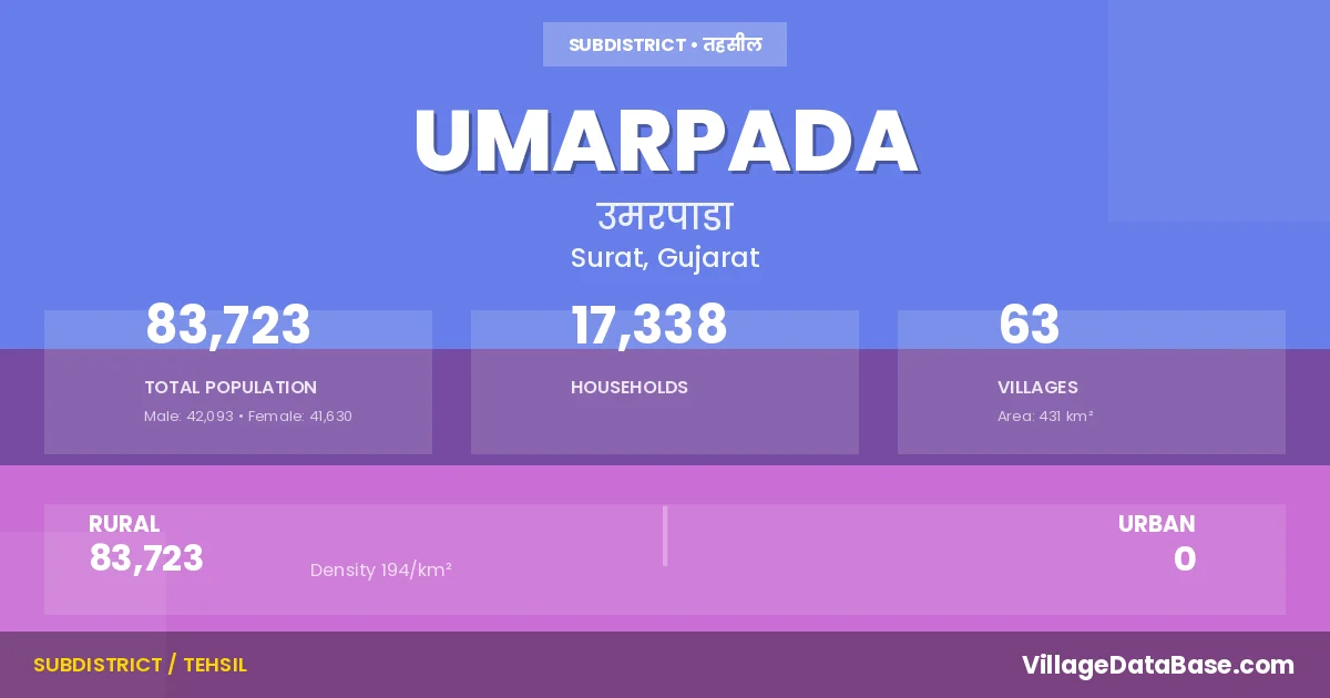
Umarpada is a town and Taluka in the Surat district of the Gujarat. In India, a Taluka is a subdivision of a district responsible for the administration and revenue collection of a specific area within the district. Talukas play a crucial role in the local governance structure, contributing significantly to the development and administration of their communities.
According to the 2011 census The total area of Umarpada Taluka is 431 km², with a population of 83723 people. The population density is 194 inhabitants per square kilometre, and there are approximately 17338 houses in the sub district.
Umarpada Taluka comprises about 63 villages. Below is a list of these villages along with information about their respective gram panchayats and the nearest town:
| # | Village Name | Gram Panchayat | Nearest Town |
|---|---|---|---|
| 1 | Ambadi | Jumawadi | Mandvi (36 km) |
| 2 | Amli Dabda | Amli Dabda | Mandvi (27 km) |
| 3 | Balalkuva | Amli Dabda | Mandvi (27 km) |
| 4 | Bardi | Sarda | Mandvi (37 km) |
| 5 | Bardipada | Nana Sutkhadka | Mandvi (56 km) |
| 6 | Bijalwadi | Sarvan Fokdi | Mandvi (34 km) |
| 7 | Bilvan | Bilvan | Mandvi (45 km) |
| 8 | Chakra | Nana Sutkhadka | Mandvi (60 km) |
| 9 | Chandrapada | Sarda | Mandvi (37 km) |
| 10 | Charni | Charni | Mandvi (40 km) |
| 11 | Chavda | Chavda | Mandvi (8 km) |
| 12 | Chimipatal | Chimipatal | Mandvi (53 km) |
| 13 | Chitalda | Chitalda | Mandvi (34 km) |
| 14 | Chokhvada | Chokhvada | Mandvi (54 km) |
| 15 | Darda | Chokhvada | Mandvi (46 km) |
| 16 | Divtan | Chokhvada | Mandvi (56 km) |
| 17 | Dongripada | Dongripada | Mandvi (53 km) |
| 18 | Ghanawad | Ghanawad | Mandvi (47 km) |
| 19 | Gondaliya | Umarkhadi | Mandvi (45 km) |
| 20 | Gopalia | Sarda | Surat (93 km) |
| 21 | Govat | Mandvi (35 km) | |
| 22 | Gundikuva | Gundikuva | Mandvi (27 km) |
| 23 | Haldhari | Nana Sutkhadka | Surat (93 km) |
| 24 | Haripura | Umarda | Mandvi (66 km) |
| 25 | Jumawadi | Jumawadi | Mandvi (58 km) |
| 26 | Kadvidadra | Pada | Mandvi (35 km) |
| 27 | Kali Jaman | Sarvan Fokdi | Mandvi (40 km) |
| 28 | Kevdi | Kevadi | Mandvi (38 km) |
| 29 | Khambha Bangli | Umarkhadi | Mandvi (32 km) |
| 30 | Khodamba | Chokhvada | Mandvi (47 km) |
| 31 | Mandan | Pada | Mandvi (27 km) |
| 32 | Moti Devrupan | Moti Devrupan | Mandvi (53 km) |
| 33 | Nana Sutkhadka | Nana Sutkhadka | Mandvi (58 km) |
| 34 | Nasarpore | Nasarpore | Surat (115 km) |
| 35 | Nava Chakra | Nava Chakra | Mandvi (57 km) |
| 36 | Pada | Pada | Mandvi (30 km) |
| 37 | Panch Amba | Chokhvada | Mandvi (43 km) |
| 38 | Pinpur | Chokhvada | Mandvi (45 km) |
| 39 | Ranikund | Umarkhadi | Jhankhvav (14 km) |
| 40 | Rudhi Gavan | Rudhi Gavan | Mandvi (63 km) |
| 41 | Sadadapani | Sarvan Fokdi | Mandvi (40 km) |
| 42 | Salli | Jumawadi | Mandvi (36 km) |
| 43 | Sampura | Pada | Mandvi (30 km) |
| 44 | Sarda | Sarda | Mandvi (37 km) |
| 45 | Sarvan Fokdi | Sarvan Fokdi | Mandvi (40 km) |
| 46 | Satvan | Satvan | Mandvi (46 km) |
| 47 | Sevlan | Nana Sutkhadka | Mandvi (61 km) |
| 48 | Taval | Chokhvada | Mandvi (52 km) |
| 49 | Umarda | Umarda | Mandvi (53 km) |
| 50 | Umargot | Umargot | Mandvi (48 km) |
| 51 | Umarjhar | Umarjhar | Surat (105 km) |
| 52 | Umarkhadi | Umarkhadi | Mandvi (34 km) |
| 53 | Umarpada | Umarpada | Mandvi (33 km) |
| 54 | Umbhariya | Umbhariya | Jhankhvav (8 km) |
| 55 | Unchvan | Unchvan | Mandvi (33 km) |
| 56 | Vadgam | Vadgam | Mandvi (65 km) |
| 57 | Vadi | Vadi | Mandvi (27 km) |
| 58 | Vadpada | Nana Sutkhadka | Mandvi (55 km) |
| 59 | Vahar | Amli Dabda | Mandvi (25 km) |
| 60 | Vakrant Amba | Jumawadi | Mandvi (48 km) |
| 61 | Velavi | Velavi | Mandvi (45 km) |
| 62 | Zarawadi | Umarda | Mandvi (67 km) |
| 63 | Zarpan | Jharpan | Surat (95 km) |
The population is distributed between urban and rural areas as follows:
| Particulars | Rural | Urban | Total |
|---|---|---|---|
| Total Population | 83723 | 0 | 83723 |
| Male Population | 42093 | 0 | 42093 |
| Female Population | 41630 | 0 | 41630 | Population Density | 194 / km² | 194 / km² |
The distribution of households in the Umarpada is:
| Rural Households | Urban Households | Total Households |
|---|---|---|
| 17338 | 0 | 17338 |
Q: What is Umarpada?
A: Umarpada is a town and in the Surat district of the Gujarat.
Q: What is the total area of Umarpada Taluka?
A: The total area of Umarpada Taluka is 431 km².
Q: What is the population of Umarpada Taluka according to the 2011 census?
A: According to the 2011 census, the population of Umarpada Taluka is 83723.
Q: What is the population density of Umarpada Taluka?
A: The population density of Umarpada Taluka is 194 inhabitants per square kilometre.
Q: How many houses are there in Umarpada Taluka?
A: There are approximately 17338 houses in Umarpada Taluka.
Q: How many villages are there in Umarpada Taluka?
A: There are about 63 villages in Umarpada Taluka.
Q: Which is the largest village by population in Umarpada Taluka?
A: The largest village by population in Umarpada Taluka is Vadi, with 5648 people.
Q: Which is the smallest village by population in Umarpada Taluka?
A: The smallest village by population in Umarpada Taluka is Bardi, with 254 people.
Q: Which is the largest village by area in Umarpada Taluka?
A: The largest village by area in Umarpada Taluka is Moti Devrupan, with 3091 km².
Q: Which is the smallest village by area in Umarpada Taluka?
A: The smallest village by area in Umarpada Taluka is Haripura, with 10 km².
Q: What is the population distribution between urban and rural areas in Umarpada Taluka?
A: The population distribution in Umarpada Taluka is entirely rural, with a total rural population of 83723.
Q: What is the male population of Umarpada Taluka?
A: The male population of Umarpada Taluka is 42093.
Q: What is the female population of Umarpada Taluka?
A: The female population of Umarpada Taluka is 41630.
Q: How is the household distribution in Umarpada Taluka?
A: The household distribution in Umarpada Taluka is entirely rural, with a total of 17338 households.
Q: How many villages in Umarpada Taluka have a population between 100 and 499?
A: There are 11 villages in Umarpada Taluka with a population between 100 and 499.
Q: How many villages in Umarpada Taluka have a population between 500 and 999?
A: There are 15 villages in Umarpada Taluka with a population between 500 and 999.
Q: How many villages in Umarpada Taluka have a population between 1000 and 1999?
A: There are 27 villages in Umarpada Taluka with a population between 1000 and 1999.
Q: How many villages in Umarpada Taluka have a population between 2000 and 2999?
A: There is 6 village in Umarpada Taluka with a population between 2000 and 2999.
Q: How many villages in Umarpada Taluka have a population between 3000 and 3999?
A: There is 2 village in Umarpada Taluka with a population between 3000 and 3999.
Q: How many villages in Umarpada Taluka have a population between 4000 and 4999?
A: There is 1 village in Umarpada Taluka with a population between 4000 and 4999.
Q: How many villages in Umarpada Taluka have a population of 5000 and above?
A: There is 1 village in Umarpada Taluka with a population of 5000 and above.
| Total Population | Villages in Sub District Of Umarpada |
|---|---|
| 100-499 | 11 |
| 500-999 | 15 |
| 1000-1999 | 27 |
| 2000-2999 | 6 |
| 3000-3999 | 2 |
| 4000-4999 | 1 |
| 5000 And Above | 1 |