District → Surendranagar
State → Gujarat
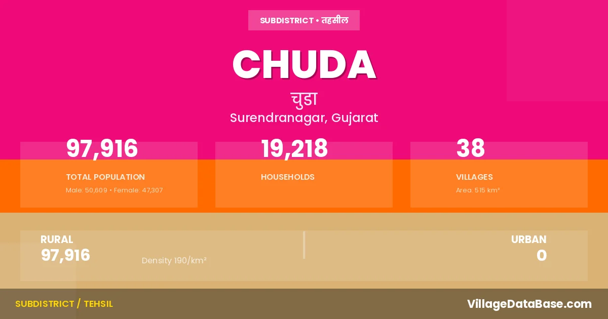
Chuda is a town and Taluka in the Surendranagar district of the Gujarat. In India, a Taluka is a subdivision of a district responsible for the administration and revenue collection of a specific area within the district. Talukas play a crucial role in the local governance structure, contributing significantly to the development and administration of their communities.
According to the 2011 census The total area of Chuda Taluka is 515 km², with a population of 97916 people. The population density is 190 inhabitants per square kilometre, and there are approximately 19218 houses in the sub district.
Chuda Taluka comprises about 38 villages. Below is a list of these villages along with information about their respective gram panchayats and the nearest town:
| # | Village Name | Gram Panchayat | Nearest Town |
|---|---|---|---|
| 1 | Acharda | Acharda | Limbdi (11 km) |
| 2 | Balala | Balala | Limbdi (25 km) |
| 3 | Bhanejada | Bhanejada | Limbdi (33 km) |
| 4 | Bhensjal | Bhensjal | Limbdi (11 km) |
| 5 | Bhrugupur | Bhrugupur | Limbdi (13 km) |
| 6 | Chachana | Chachana | Limbdi (17 km) |
| 7 | Chachka | Chachka | Limbdi (25 km) |
| 8 | Chamardi | Chamardi | Dhandhuka (16 km) |
| 9 | Chhalala | Chhalala | Limbdi (25 km) |
| 10 | Chhatriyala | Chhatriyala | Limbdi (21 km) |
| 11 | Chokdi | Chokdi | Limbdi (28 km) |
| 12 | Chuda | Chuda | Limbdi (18 km) |
| 13 | Darod | Darod | Dhandhuka (10 km) |
| 14 | Gokharwala | Gokharwala | Limbdi (20 km) |
| 15 | Jepar | Jepar | Limbdi (21 km) |
| 16 | Juni Morwad | Juni Morwad | Limbdi (28 km) |
| 17 | Kanthariya | Kanthariya | Limbdi (27 km) |
| 18 | Karmad | Karmad | Limbdi (18 km) |
| 19 | Karol | Karol | Limbdi (9 km) |
| 20 | Khandiya | Khandiya | Limbdi (15 km) |
| 21 | Korda | Korda | Limbdi (30 km) |
| 22 | Kudla | Kudla | Limbdi (27 km) |
| 23 | Laliyad | Laliyad | Limbdi (14 km) |
| 24 | Minapur | Minapur | Limbdi (28 km) |
| 25 | Mojidad | Mojidad | Limbdi (15 km) |
| 26 | Nagnesh | Nagnesh | Limbdi (25 km) |
| 27 | Navi Morwad | Navi Morwad | Limbdi (28 km) |
| 28 | Ramdevgadh | Ramdevgadh | Limbdi (24 km) |
| 29 | Rangpur | Rangpur | Dhandhuka (7 km) |
| 30 | Samdhiyala | Samdhiyala | Limbdi (30 km) |
| 31 | Sejakpar | Sejakpar | Limbdi (15 km) |
| 32 | Sontha | Sontha | Dhandhuka (17 km) |
| 33 | Vanala | Vanala | Dhandhuka (10 km) |
| 34 | Vaniyavadar | Vaniyavadar | Limbdi (24 km) |
| 35 | Vejalka | Vejalka | Limbdi (17 km) |
| 36 | Velavadar | Velavadar | Limbdi (24 km) |
| 37 | Zinzavadar | Zinzavadar | Limbdi (24 km) |
| 38 | Zobala | Zobala | Limbdi (25 km) |
The population is distributed between urban and rural areas as follows:
| Particulars | Rural | Urban | Total |
|---|---|---|---|
| Total Population | 97916 | 0 | 97916 |
| Male Population | 50609 | 0 | 50609 |
| Female Population | 47307 | 0 | 47307 | Population Density | 190 / km² | 190 / km² |
The distribution of households in the Chuda is:
| Rural Households | Urban Households | Total Households |
|---|---|---|
| 19218 | 0 | 19218 |
Q: What is Chuda?
A: Chuda is a town and in the Surendranagar district of the Gujarat.
Q: What is the total area of Chuda Taluka?
A: The total area of Chuda Taluka is 515 km².
Q: What is the population of Chuda Taluka according to the 2011 census?
A: According to the 2011 census, the population of Chuda Taluka is 97916.
Q: What is the population density of Chuda Taluka?
A: The population density of Chuda Taluka is 190 inhabitants per square kilometre.
Q: How many houses are there in Chuda Taluka?
A: There are approximately 19218 houses in Chuda Taluka.
Q: How many villages are there in Chuda Taluka?
A: There are about 38 villages in Chuda Taluka.
Q: Which is the largest village by population in Chuda Taluka?
A: The largest village by population in Chuda Taluka is Chuda, with 15350 people.
Q: Which is the smallest village by population in Chuda Taluka?
A: The smallest village by population in Chuda Taluka is Zinzavadar, with 577 people.
Q: Which is the largest village by area in Chuda Taluka?
A: The largest village by area in Chuda Taluka is Chuda, with 4332 km².
Q: Which is the smallest village by area in Chuda Taluka?
A: The smallest village by area in Chuda Taluka is Zinzavadar, with 265 km².
Q: What is the population distribution between urban and rural areas in Chuda Taluka?
A: The population distribution in Chuda Taluka is entirely rural, with a total rural population of 97916.
Q: What is the male population of Chuda Taluka?
A: The male population of Chuda Taluka is 50609.
Q: What is the female population of Chuda Taluka?
A: The female population of Chuda Taluka is 47307.
Q: How is the household distribution in Chuda Taluka?
A: The household distribution in Chuda Taluka is entirely rural, with a total of 19218 households.
Q: How many villages in Chuda Taluka have a population between 500 and 999?
A: There are 7 villages in Chuda Taluka with a population between 500 and 999.
Q: How many villages in Chuda Taluka have a population between 1000 and 1999?
A: There are 14 villages in Chuda Taluka with a population between 1000 and 1999.
Q: How many villages in Chuda Taluka have a population between 2000 and 2999?
A: There is 7 village in Chuda Taluka with a population between 2000 and 2999.
Q: How many villages in Chuda Taluka have a population between 3000 and 3999?
A: There is 4 village in Chuda Taluka with a population between 3000 and 3999.
Q: How many villages in Chuda Taluka have a population between 4000 and 4999?
A: There is 1 village in Chuda Taluka with a population between 4000 and 4999.
Q: How many villages in Chuda Taluka have a population of 5000 and above?
A: There is 5 village in Chuda Taluka with a population of 5000 and above.
| Total Population | Villages in Sub District Of Chuda |
|---|---|
| 500-999 | 7 |
| 1000-1999 | 14 |
| 2000-2999 | 7 |
| 3000-3999 | 4 |
| 4000-4999 | 1 |
| 5000 And Above | 5 |