Atholi: A Town and Tehsil in Kishtwar district
District → Kishtwar
State → Jammu & Kashmir
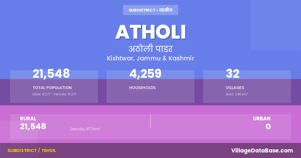
Atholi is a town and Tehsil in the Kishtwar district of the Jammu & Kashmir. In India, a Tehsil is a subdivision of a district responsible for the administration and revenue collection of a specific area within the district. Tehsils play a crucial role in the local governance structure, contributing significantly to the development and administration of their communities.
According to the 2011 census The total area of Atholi Tehsil is 248 km², with a population of 21548 people. The population density is 87 inhabitants per square kilometre, and there are approximately 4259 houses in the sub district.
Atholi Tehsil comprises about 32 villages. Below is a list of these villages along with information about their respective gram panchayats and the nearest town:
| # | Village Name | Gram Panchayat | Nearest Town |
|---|---|---|---|
| 1 | Afani | Affani | Kishtwar (85 km) |
| 2 | Atholi | Atholi | Kishtwar (71 km) |
| 3 | Batwas | Thun | Kishtwar (116 km) |
| 4 | Chashoti | Muchail | Kishtwar (79 km) |
| 5 | Cheto | Tihari | Kishtwar] (83 km) |
| 6 | Chug | Thun | Kishtwar (118 km) |
| 7 | Garh Padder | Massu | Kishtwar (96 km) |
| 8 | Gulab Garh | Gulabgarh | Kishtwar (83 km) |
| 9 | Hamori | Muchail | Kishtwar (85 km) |
| 10 | Hangu | Muchail | Kishtwar (80 km) |
| 11 | Ishtahari | Ishatyari | Kishtwar (125 km) |
| 12 | Jar | Jar | Kishtwar (70 km) |
| 13 | Kaban | Sohal | Kishtwar (80 km) |
| 14 | Kadail | Jar | Kistwar (50 km) |
| 15 | Kidru | Jar | Kishtwar (52 km) |
| 16 | Kundal | Kundal | Kishtwar (75 km) |
| 17 | Layee | Affani | Kishtwar (55 km) |
| 18 | Leoundi | Gulabgarh | Kishtwar (85 km) |
| 19 | Ligri | Ligri | Kishtwar (80 km) |
| 20 | Losain | Muchail | Kishtwar (94 km) |
| 21 | Luder | Kundal | Kishtwar (75 km) |
| 22 | Machail | Muchail | Kishtwar (92 km) |
| 23 | Massu | Massu | Kishtwar (75 km) |
| 24 | Mati | Gulabgarh | Kishtwar (50 km) |
| 25 | Muthal | Thun | Kishtwar (118 km) |
| 26 | Ongayee | Sohal | Kishtwar (85 km) |
| 27 | Palali | Palali | Kishtwar (58 km) |
| 28 | Pandail | Ligri | Kishtwar (81 km) |
| 29 | Sazar | Jar | Kishtwar (30 km) |
| 30 | Sohal | Sohal | Kishtwar (106 km) |
| 31 | Tun | Thun | Kishtwar (98 km) |
| 32 | Tyari | Tihari | Kishtwar (108 km) |
The population is distributed between urban and rural areas as follows:
| Particulars | Rural | Urban | Total |
|---|---|---|---|
| Total Population | 21548 | 0 | 21548 |
| Male Population | 11277 | 0 | 11277 |
| Female Population | 10271 | 0 | 10271 | Population Density | 87 / km² | 87 / km² |
The distribution of households in the Atholi is:
| Rural Households | Urban Households | Total Households |
|---|---|---|
| 4259 | 0 | 4259 |
Q: What is Atholi?
A: Atholi is a town and in the Kishtwar district of the Jammu & Kashmir.
Q: What is the total area of Atholi Tehsil?
A: The total area of Atholi Tehsil is 248 km².
Q: What is the population of Atholi Tehsil according to the 2011 census?
A: According to the 2011 census, the population of Atholi Tehsil is 21548.
Q: What is the population density of Atholi Tehsil?
A: The population density of Atholi Tehsil is 87 inhabitants per square kilometre.
Q: How many houses are there in Atholi Tehsil?
A: There are approximately 4259 houses in Atholi Tehsil.
Q: How many villages are there in Atholi Tehsil?
A: There are about 32 villages in Atholi Tehsil.
Q: Which is the largest village by population in Atholi Tehsil?
A: The largest village by population in Atholi Tehsil is Ligri, with 1824 people.
Q: Which is the smallest village by population in Atholi Tehsil?
A: The smallest village by population in Atholi Tehsil is Layee, with 218 people.
Q: Which is the largest village by area in Atholi Tehsil?
A: The largest village by area in Atholi Tehsil is Kaban, with 3475 km².
Q: Which is the smallest village by area in Atholi Tehsil?
A: The smallest village by area in Atholi Tehsil is Jar, with 58 km².
Q: What is the population distribution between urban and rural areas in Atholi Tehsil?
A: The population distribution in Atholi Tehsil is entirely rural, with a total rural population of 21548.
Q: What is the male population of Atholi Tehsil?
A: The male population of Atholi Tehsil is 11277.
Q: What is the female population of Atholi Tehsil?
A: The female population of Atholi Tehsil is 10271.
Q: How is the household distribution in Atholi Tehsil?
A: The household distribution in Atholi Tehsil is entirely rural, with a total of 4259 households.
Q: How many villages in Atholi Tehsil have a population between 100 and 499?
A: There are 16 villages in Atholi Tehsil with a population between 100 and 499.
Q: How many villages in Atholi Tehsil have a population between 500 and 999?
A: There are 8 villages in Atholi Tehsil with a population between 500 and 999.
Q: How many villages in Atholi Tehsil have a population between 1000 and 1999?
A: There are 8 villages in Atholi Tehsil with a population between 1000 and 1999.
| Total Population | Villages in Sub District Of Atholi |
|---|---|
| 100-499 | 16 |
| 500-999 | 8 |
| 1000-1999 | 8 |