District → Punch
State → Jammu & Kashmir
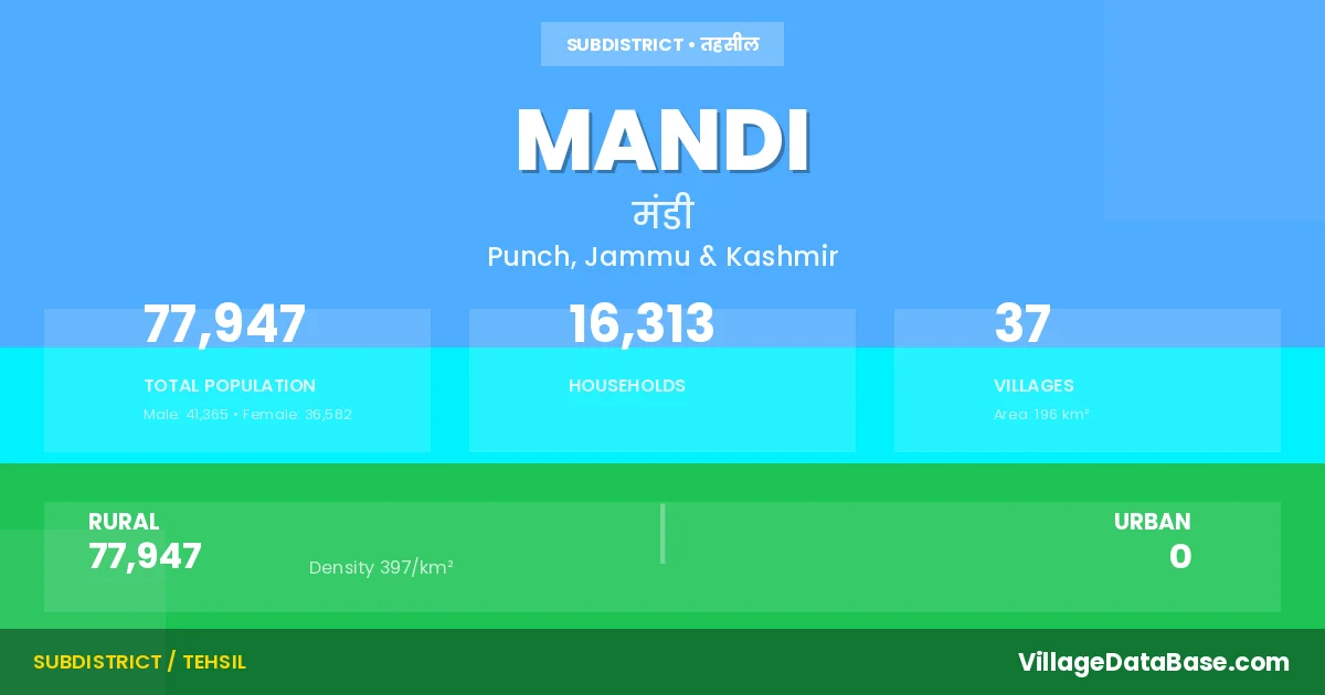
Mandi is a town and Tehsil in the Punch district of the Jammu & Kashmir. In India, a Tehsil is a subdivision of a district responsible for the administration and revenue collection of a specific area within the district. Tehsils play a crucial role in the local governance structure, contributing significantly to the development and administration of their communities.
According to the 2011 census The total area of Mandi Tehsil is 196 km², with a population of 77947 people. The population density is 397 inhabitants per square kilometre, and there are approximately 16313 houses in the sub district.
Mandi Tehsil comprises about 37 villages. Below is a list of these villages along with information about their respective gram panchayats and the nearest town:
| # | Village Name | Gram Panchayat | Nearest Town |
|---|---|---|---|
| 1 | Arai | Arai Haveli | Punch (20 km) |
| 2 | Atoli | Attoli | Punch (14 km) |
| 3 | Azamabad | Azamabad | Punch (13 km) |
| 4 | Baila | Mandi | Punch (15 km) |
| 5 | Bandikama Khan | Chakrara | Punch (21 km) |
| 6 | Brachhar | Brachhar | Punch (20 km) |
| 7 | Chak Rara | Chakrara | Punch (19 km) |
| 8 | Chhambar Kanaria | Chhamber Kanari | Punch (10 km) |
| 9 | Chikri Ban | Chikriban | Punch (24 km) |
| 10 | Chilla | Chhela | Punch (14 km) |
| 11 | Dana Dhakran | Dhara | Punch (20 km) |
| 12 | Danugam | Dunugam | Punch (16 km) |
| 13 | Dedar Balnai | Balnai | Punch (13 km) |
| 14 | Dhangri | Chhela | Punch (13 km) |
| 15 | Dhara | Dhara | Punch (18 km) |
| 16 | Fatehpur | Fathepur | Punch (16 km) |
| 17 | Gagrian | Gagrian B | Punch (22 km) |
| 18 | Gali | Gali Pindi | Punch (29 km) |
| 19 | Gali Nag | Jandrola | Punch (23 km) |
| 20 | Jalian | Attoli | Punch (19 km) |
| 21 | Jandrola | Jandrola | Punch (22 km) |
| 22 | Kalani | Fathepur | Punch (12 km) |
| 23 | Kehnu | Fathepur | Punch (13 km) |
| 24 | Lohelbelah | Loyal Bela | Punch (22 km) |
| 25 | Loran | Battal Kote Loran | Punch (32 km) |
| 26 | Mandi | Mandi | Punch (18 km) |
| 27 | Markote | Brachhar | Punch (18 km) |
| 28 | Marnote | Mandi | Punch (17 km) |
| 29 | Pindi | Gali Pindi | Punch (26 km) |
| 30 | Plera | Chikriban | Punch (22 km) |
| 31 | Raj Pur | Rajpura | Punch (20 km) |
| 32 | Salunian | Saloonia | Punch (19 km) |
| 33 | Sathra | Sathra | Punch (18 km) |
| 34 | Sawajian | Sawjian A | Mandi (20 km) |
| 35 | Seikhlu | Seiklu | Punch (17 km) |
| 36 | Seroi | Attoli | Mandi (7 km) |
| 37 | Trichal | Mandi | Punch (13 km) |
The population is distributed between urban and rural areas as follows:
| Particulars | Rural | Urban | Total |
|---|---|---|---|
| Total Population | 77947 | 0 | 77947 |
| Male Population | 41365 | 0 | 41365 |
| Female Population | 36582 | 0 | 36582 | Population Density | 397 / km² | 397 / km² |
The distribution of households in the Mandi is:
| Rural Households | Urban Households | Total Households |
|---|---|---|
| 16313 | 0 | 16313 |
Q: What is Mandi?
A: Mandi is a town and in the Punch district of the Jammu & Kashmir.
Q: What is the total area of Mandi Tehsil?
A: The total area of Mandi Tehsil is 196 km².
Q: What is the population of Mandi Tehsil according to the 2011 census?
A: According to the 2011 census, the population of Mandi Tehsil is 77947.
Q: What is the population density of Mandi Tehsil?
A: The population density of Mandi Tehsil is 397 inhabitants per square kilometre.
Q: How many houses are there in Mandi Tehsil?
A: There are approximately 16313 houses in Mandi Tehsil.
Q: How many villages are there in Mandi Tehsil?
A: There are about 37 villages in Mandi Tehsil.
Q: Which is the largest village by population in Mandi Tehsil?
A: The largest village by population in Mandi Tehsil is Loran, with 11866 people.
Q: Which is the smallest village by population in Mandi Tehsil?
A: The smallest village by population in Mandi Tehsil is Jalian, with 128 people.
Q: Which is the largest village by area in Mandi Tehsil?
A: The largest village by area in Mandi Tehsil is Sawajian, with 2680 km².
Q: Which is the smallest village by area in Mandi Tehsil?
A: The smallest village by area in Mandi Tehsil is Marnote, with 26 km².
Q: What is the population distribution between urban and rural areas in Mandi Tehsil?
A: The population distribution in Mandi Tehsil is entirely rural, with a total rural population of 77947.
Q: What is the male population of Mandi Tehsil?
A: The male population of Mandi Tehsil is 41365.
Q: What is the female population of Mandi Tehsil?
A: The female population of Mandi Tehsil is 36582.
Q: How is the household distribution in Mandi Tehsil?
A: The household distribution in Mandi Tehsil is entirely rural, with a total of 16313 households.
Q: How many villages in Mandi Tehsil have a population between 100 and 499?
A: There are 5 villages in Mandi Tehsil with a population between 100 and 499.
Q: How many villages in Mandi Tehsil have a population between 500 and 999?
A: There are 7 villages in Mandi Tehsil with a population between 500 and 999.
Q: How many villages in Mandi Tehsil have a population between 1000 and 1999?
A: There are 11 villages in Mandi Tehsil with a population between 1000 and 1999.
Q: How many villages in Mandi Tehsil have a population between 2000 and 2999?
A: There is 6 village in Mandi Tehsil with a population between 2000 and 2999.
Q: How many villages in Mandi Tehsil have a population between 3000 and 3999?
A: There is 5 village in Mandi Tehsil with a population between 3000 and 3999.
Q: How many villages in Mandi Tehsil have a population of 5000 and above?
A: There is 3 village in Mandi Tehsil with a population of 5000 and above.
| Total Population | Villages in Sub District Of Mandi |
|---|---|
| 100-499 | 5 |
| 500-999 | 7 |
| 1000-1999 | 11 |
| 2000-2999 | 6 |
| 3000-3999 | 5 |
| 5000 And Above | 3 |