Mayur Hand: A Town and Subdivision in Chatra district
District → Chatra
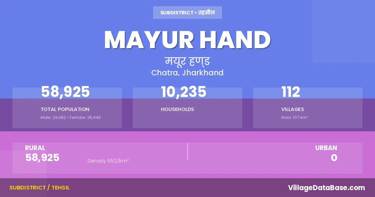
State → Jharkhand
Mayur Hand is a town and Subdivision in the Chatra district of the Jharkhand. In India, a Subdivision is a subdivision of a district responsible for the administration and revenue collection of a specific area within the district. Subdivisions play a crucial role in the local governance structure, contributing significantly to the development and administration of their communities.
According to the 2011 census The total area of Mayur Hand Subdivision is 107 km², with a population of 58925 people. The population density is 552 inhabitants per square kilometre, and there are approximately 10235 houses in the sub district.
Mayur Hand Subdivision comprises about 112 villages. Below is a list of these villages along with information about their respective gram panchayats and the nearest town:
| # | Village Name | Gram Panchayat | Nearest Town |
|---|---|---|---|
| 1 | Alagdiha | Kadganwa Kala | Mayur Hand |
| 2 | Ambatari | Pandni | Mayur Hand |
| 3 | Amjhar | Pandni | Mayur Hand |
| 4 | Balia | Fulang | Mayur Hand |
| 5 | Bamhandih | Kadganwa Kala | Mayur Hand |
| 6 | Banha | Belkhori | Mayur Hand |
| 7 | Banri Gamharia | Kadganwa Kala | Mayur Hand |
| 8 | Bansdih | Fulang | Mayur Hand |
| 9 | Baradih | Manjhganwa | Chatra |
| 10 | Barakar | Fulang | Mayur Hand |
| 11 | Bela | Dhankheri | Mayur Hand |
| 12 | Belkhori | Belkhori | Chatra |
| 13 | Bengwa | Fulang | Mayur Hand |
| 14 | Bharchanda | Pandni | Mayur Hand |
| 15 | Bhikhari Chak | Kadganwa Kala | Mayur Hand |
| 16 | Birbhan Chak | Pandni | Mayur Hand |
| 17 | Chandi Alias Pandi | Pandni | Mayur Hand |
| 18 | Chauria | Pandni | Mayur Hand |
| 19 | Cheri | Soki | Mayur Hand |
| 20 | Chhagaria | Manjhganwa | Chatra |
| 21 | Chhotu Chak | Soki | Mayur Hand |
| 22 | Chontha | Karma | Mayur Hand |
| 23 | Chorha | Husia | Mayur Hand |
| 24 | Deosar | Kadganwa Kala | Mayur Hand |
| 25 | Dhanarhi | Kadganwa Kala | Mayur Hand |
| 26 | Dhangawan | Kadganwa Kala | Mayur Hand |
| 27 | Dharampur | Petaderi | Chatra |
| 28 | Dhewadauri | Soki | Mayur Hand |
| 29 | Dhibar | Kadganwa Kala | Mayur Hand |
| 30 | Dighi | Kadganwa Kala | Mayur Hand |
| 31 | Dorhi | Karma | Mayur Hand |
| 32 | Dubi | Kadganwa Kala | Mayur Hand |
| 33 | Duhai | Pandni | Mayur Hand |
| 34 | Ektara | Belkhori | Hazaribagh |
| 35 | Gada | Kadganwa Kala | Mayur Hand |
| 36 | Gamharia | Kadganwa Kala | Mayur Hand |
| 37 | Ganeshpur | Husia | Mayur Hand |
| 38 | Gorea | Kadganwa Kala | Mayur Hand |
| 39 | Gurwadih | Soki | Mayur Hand |
| 40 | Harahi | Husia | Mayur Hand |
| 41 | Husia | Husia | Mayur Hand |
| 42 | Jamunia | Kadganwa Kala | Mayur Hand |
| 43 | Jhardag | Fulang | Mayur Hand |
| 44 | Jindapur | Kadganwa Kala | Mayur Hand |
| 45 | Kadgawan Kalan | Kadganwa Kala | Mayur Hand |
| 46 | Kadgawan Khurd | Kadganwa Kala | Mayur Hand |
| 47 | Kanaudichotha | Petaderi | Chatra (55 km) |
| 48 | Kanchanpur | Fulang | Mayur Hand |
| 49 | Kanti | Pandni | Mayur Hand |
| 50 | Karma | Karma | Mayur Hand |
| 51 | Kenduahi Alias Babhandih | Shaharjam | Mayur Hand |
| 52 | Khaira | Belkhori | Hazaribagh |
| 53 | Koili | Petaderi | Chatra |
| 54 | Kumhari | Koni | Mayur Hand |
| 55 | Kundri | Manjhganwa | Mayur Hand |
| 56 | Larahi | Karma | Mayur Hand |
| 57 | Madhania | Manjhganwa | Chatra |
| 58 | Mahesa | Manjhganwa | Mayur Hand |
| 59 | Mahuari | Husia | Mayur Hand |
| 60 | Mahugain | Fulang | Mayur Hand |
| 61 | Majhauli | Karma | Mayur Hand |
| 62 | Majhauli Kalan | Kadganwa Kala | Mayur Hand |
| 63 | Majhauli Khurd | Kadganwa Kala | Mayur Hand |
| 64 | Majhgawan | Manjhganwa | Chatra |
| 65 | Majhila | Petaderi | Chatra |
| 66 | Majurhand | Mayurhand | Chatra |
| 67 | Makhrol | Kadganwa Kala | Mayur Hand |
| 68 | Mandhania | Manjhganwa | Chatra |
| 69 | Manhari | Pandni | Mayur Hand |
| 70 | Manhe | Petaderi | Chatra |
| 71 | Mathuri Chak | Pandni | Mayur Hand |
| 72 | Mauna | Pandni | Mayur Hand |
| 73 | Mayapur | Pandni | Mayur Hand |
| 74 | Narchahi | Kadganwa Kala | Mayur Hand |
| 75 | Naudiha | Soki | Mayur Hand |
| 76 | Nawada | Petaderi | Chatra |
| 77 | Nima | Kadganwa Kala | Mayur Hand |
| 78 | Pachghara | Pandni | Mayur Hand |
| 79 | Pakaria | Kadganwa Kala | Mayur Hand |
| 80 | Papro | Karma | Mayur Hand |
| 81 | Paranpur | Kadganwa Kala | Mayur Hand |
| 82 | Parasi | Fulang | Mayur Hand |
| 83 | Parsawan | Mayurhand | Chatra |
| 84 | Partappur | Petaderi | Chatra |
| 85 | Parwaria Dakhinwari | Mayurhand | Chatra |
| 86 | Parwaria Uttarwari | Mayurhand | Chatra |
| 87 | Pathra | Fulang | Mayur Hand |
| 88 | Petadiri | Petaderi | Chatra |
| 89 | Phulang | Fulang | Mayur Hand |
| 90 | Pipra | Nawada | Mayur Hand |
| 91 | Puraini | Husia | Mayur Hand |
| 92 | Sabalpur | Manjhganwa | Chatra |
| 93 | Sadafar | Petaderi | Chatra |
| 94 | Salaiatanr | Manjhganwa | Mayur Hand |
| 95 | Sale | Belkhori | Mayur Hand |
| 96 | Sargaon | Husia | Mayur Hand |
| 97 | Sewai Kalan | Kadganwa Kala | Mayur Hand |
| 98 | Sewai Khurd | Kadganwa Kala | Mayur Hand |
| 99 | Sewal | Karma | Mayur Hand |
| 100 | Siduwari | Kadganwa Kala | Mayur Hand |
| 101 | Simaria | Mayurhand | Hazaribagh (50 km) |
| 102 | Singhrawan | Husia | Mayur Hand |
| 103 | Soki | Soki | Mayur Hand |
| 104 | Sonpura Kalan | Pandni | Mayur Hand |
| 105 | Sonpura Khurd | Pandni | Mayur Hand |
| 106 | Suhai | Pandni | Mayur Hand |
| 107 | Surajpura | Pandni | Mayur Hand |
| 108 | Tilaitanr | Fulang | Mayur Hand |
| 109 | Tilra | Manjhganwa | Chatra |
| 110 | Upraunda | Belkhori | Chatra |
| 111 | Ursi | Fulang | Mayur Hand |
| 112 | Varkara | Husia | Mayur Hand |
The population is distributed between urban and rural areas as follows:
| Particulars | Rural | Urban | Total |
|---|---|---|---|
| Total Population | 58925 | 0 | 58925 |
| Male Population | 29482 | 0 | 29482 |
| Female Population | 29443 | 0 | 29443 | Population Density | 552 / km² | 552 / km² |
The distribution of households in the Mayur Hand is:
| Rural Households | Urban Households | Total Households |
|---|---|---|
| 10235 | 0 | 10235 |
Q: What is Mayur Hand?
A: Mayur Hand is a town and in the Chatra district of the Jharkhand.
Q: What is the total area of Mayur Hand Subdivision?
A: The total area of Mayur Hand Subdivision is 107 km².
Q: What is the population of Mayur Hand Subdivision according to the 2011 census?
A: According to the 2011 census, the population of Mayur Hand Subdivision is 58925.
Q: What is the population density of Mayur Hand Subdivision?
A: The population density of Mayur Hand Subdivision is 552 inhabitants per square kilometre.
Q: How many houses are there in Mayur Hand Subdivision?
A: There are approximately 10235 houses in Mayur Hand Subdivision.
Q: How many villages are there in Mayur Hand Subdivision?
A: There are about 112 villages in Mayur Hand Subdivision.
Q: Which is the largest village by population in Mayur Hand Subdivision?
A: The largest village by population in Mayur Hand Subdivision is Majurhand, with 3404 people.
Q: Which is the smallest village by population in Mayur Hand Subdivision?
A: The smallest village by population in Mayur Hand Subdivision is Bharchanda, with 0 people.
Q: Which is the largest village by area in Mayur Hand Subdivision?
A: The largest village by area in Mayur Hand Subdivision is Karma, with 785 km².
Q: Which is the smallest village by area in Mayur Hand Subdivision?
A: The smallest village by area in Mayur Hand Subdivision is Chhotu Chak, with 6 km².
Q: What is the population distribution between urban and rural areas in Mayur Hand Subdivision?
A: The population distribution in Mayur Hand Subdivision is entirely rural, with a total rural population of 58925.
Q: What is the male population of Mayur Hand Subdivision?
A: The male population of Mayur Hand Subdivision is 29482.
Q: What is the female population of Mayur Hand Subdivision?
A: The female population of Mayur Hand Subdivision is 29443.
Q: How is the household distribution in Mayur Hand Subdivision?
A: The household distribution in Mayur Hand Subdivision is entirely rural, with a total of 10235 households.
Q: How many villages in Mayur Hand Subdivision have a population of less than 100?
A: There are 20 villages in Mayur Hand Subdivision with a population of less than 100.
Q: How many villages in Mayur Hand Subdivision have a population between 100 and 499?
A: There are 57 villages in Mayur Hand Subdivision with a population between 100 and 499.
Q: How many villages in Mayur Hand Subdivision have a population between 500 and 999?
A: There are 20 villages in Mayur Hand Subdivision with a population between 500 and 999.
Q: How many villages in Mayur Hand Subdivision have a population between 1000 and 1999?
A: There are 12 villages in Mayur Hand Subdivision with a population between 1000 and 1999.
Q: How many villages in Mayur Hand Subdivision have a population between 2000 and 2999?
A: There is 2 village in Mayur Hand Subdivision with a population between 2000 and 2999.
Q: How many villages in Mayur Hand Subdivision have a population between 3000 and 3999?
A: There is 1 village in Mayur Hand Subdivision with a population between 3000 and 3999.
| Total Population | Villages in Sub District Of Mayur Hand |
|---|---|
| Less than 100 | 20 |
| 100-499 | 57 |
| 500-999 | 20 |
| 1000-1999 | 12 |
| 2000-2999 | 2 |
| 3000-3999 | 1 |