District → Gumla
State → Jharkhand
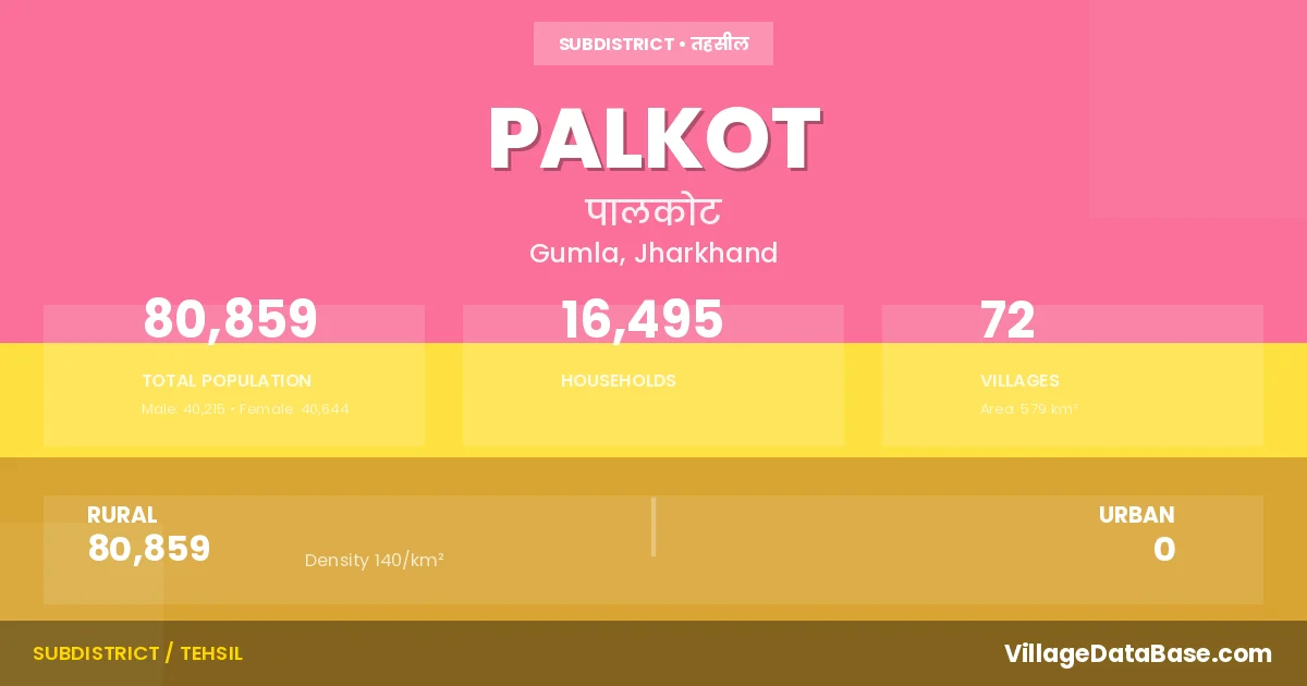
Palkot is a town and Subdivision in the Gumla district of the Jharkhand. In India, a Subdivision is a subdivision of a district responsible for the administration and revenue collection of a specific area within the district. Subdivisions play a crucial role in the local governance structure, contributing significantly to the development and administration of their communities.
According to the 2011 census The total area of Palkot Subdivision is 579 km², with a population of 80859 people. The population density is 140 inhabitants per square kilometre, and there are approximately 16495 houses in the sub district.
Palkot Subdivision comprises about 72 villages. Below is a list of these villages along with information about their respective gram panchayats and the nearest town:
| # | Village Name | Gram Panchayat | Nearest Town |
|---|---|---|---|
| 1 | Akhrakona | Bilingbira | Gumla |
| 2 | Alangkera | Palkot North | Gumla |
| 3 | Bagesara | Bagesera | Palkot |
| 4 | Baghma | Baghima | Palkot |
| 5 | Bajra | Dahupani | Gumla |
| 6 | Banaidega | Jhikirma | Palkot |
| 7 | Bangru | Bangru | Gumla |
| 8 | Bardih | Tapkara | Palkot |
| 9 | Bhaunratoli | Bilingbira | Gumla |
| 10 | Bhusunditoli | Kulukera | Gumla |
| 11 | Bilingbira | Bilingbira | Gumla |
| 12 | Chainpur | Tengariya | Gumla |
| 13 | Chirodih | Koleng | Gumla |
| 14 | Dahupani | Dahupani | Gumla |
| 15 | Damkara | Bangru | Gumla |
| 16 | Danipani | Dahupani | Gumla |
| 17 | Deogaon | Tapkara | Palkot |
| 18 | Dombabira | Bilingbira | Gumla |
| 19 | Goja | Umra | Palkot |
| 20 | Gonmer | Umra | Palkot |
| 21 | Gurgura | Baghima | Palkot |
| 22 | Gurma | Koleng | Palkot |
| 23 | Hansdoin | Baghima | Palkot |
| 24 | Jaldega | Dahupani | Gumla |
| 25 | Jhikirma | Jhikirma | Palkot |
| 26 | Jina | Tapkara | Palkot |
| 27 | Kaimba | Tengariya | Ranchi |
| 28 | Kandebewra | Bilingbira | Gumla |
| 29 | Kasira | Umra | Palkot |
| 30 | Keratoli | Bilingbira | Palkot |
| 31 | Kesidih | Dahupani | Gumla |
| 32 | Kharpani | Dahupani | Palkot |
| 33 | Kharwadih | Koleng | Palkot |
| 34 | Khatgaon | Tapkara | Palkot |
| 35 | Koenjali | Bangru | Palkot |
| 36 | Koinardanr | Dahupani | Palkot |
| 37 | Kolang | Koleng | Gumla |
| 38 | Konrekera | Dahupani | Palkot |
| 39 | Kulbir | Koleng | Gumla |
| 40 | Kullukera | Kulukera | Gumla |
| 41 | Kura | Bangru | Gumla |
| 42 | Kurum | Umra | Palkot |
| 43 | Kutuadih | Bilingbira | Palkot |
| 44 | Ladhudera | Bilingbira | Palkot |
| 45 | Litim | Umra | Palkot |
| 46 | Lodhma | Tapkara | Palkot |
| 47 | Lotwa | Dahupani | Palkot |
| 48 | Malai | Bagesera | Palkot |
| 49 | Marda | Bagesera | Palkot |
| 50 | Nathpur | Nathpur | Palkot |
| 51 | Obira | Kulukera | Palkot |
| 52 | Orbenga | Jhikirma | Palkot |
| 53 | Palkot | Palkot North | Palkot |
| 54 | Panisani | Bangru | Gumla |
| 55 | Petsera | Bangru | Patsara |
| 56 | Pithartoli | Dahupani | Palkot |
| 57 | Pojenga | Tapkara | Palkot |
| 58 | Rengola | Bangru | Gumla |
| 59 | Rewra | Tapkara | Palkot |
| 60 | Rokedega | Dahupani | Palkot |
| 61 | Sanaidih | Bilingbira | Palkot |
| 62 | Sarubera | Kulukera | Palkot |
| 63 | Satkhari | Nathpur | Ranchi |
| 64 | Semra | Koleng | Palkot |
| 65 | Sijang | Kulukera | Palkot |
| 66 | Solga | Jhikirma | Palkot |
| 67 | Sundridih | Dahupani | Palkot |
| 68 | Tapkara | Tapkara | Palkot |
| 69 | Tengariya | Tengariya | Gumla |
| 70 | Tetartoli | Dahupani | Palkot |
| 71 | Tirra | Bagesera | Palkot |
| 72 | Umra | Umra | Palkot |
The population is distributed between urban and rural areas as follows:
| Particulars | Rural | Urban | Total |
|---|---|---|---|
| Total Population | 80859 | 0 | 80859 |
| Male Population | 40215 | 0 | 40215 |
| Female Population | 40644 | 0 | 40644 | Population Density | 140 / km² | 140 / km² |
The distribution of households in the Palkot is:
| Rural Households | Urban Households | Total Households |
|---|---|---|
| 16495 | 0 | 16495 |
Q: What is Palkot?
A: Palkot is a town and in the Gumla district of the Jharkhand.
Q: What is the total area of Palkot Subdivision?
A: The total area of Palkot Subdivision is 579 km².
Q: What is the population of Palkot Subdivision according to the 2011 census?
A: According to the 2011 census, the population of Palkot Subdivision is 80859.
Q: What is the population density of Palkot Subdivision?
A: The population density of Palkot Subdivision is 140 inhabitants per square kilometre.
Q: How many houses are there in Palkot Subdivision?
A: There are approximately 16495 houses in Palkot Subdivision.
Q: How many villages are there in Palkot Subdivision?
A: There are about 72 villages in Palkot Subdivision.
Q: Which is the largest village by population in Palkot Subdivision?
A: The largest village by population in Palkot Subdivision is Palkot, with 8945 people.
Q: Which is the smallest village by population in Palkot Subdivision?
A: The smallest village by population in Palkot Subdivision is Danipani, with 134 people.
Q: Which is the largest village by area in Palkot Subdivision?
A: The largest village by area in Palkot Subdivision is Sarubera, with 2900 km².
Q: Which is the smallest village by area in Palkot Subdivision?
A: The smallest village by area in Palkot Subdivision is Panisani, with 88 km².
Q: What is the population distribution between urban and rural areas in Palkot Subdivision?
A: The population distribution in Palkot Subdivision is entirely rural, with a total rural population of 80859.
Q: What is the male population of Palkot Subdivision?
A: The male population of Palkot Subdivision is 40215.
Q: What is the female population of Palkot Subdivision?
A: The female population of Palkot Subdivision is 40644.
Q: How is the household distribution in Palkot Subdivision?
A: The household distribution in Palkot Subdivision is entirely rural, with a total of 16495 households.
Q: How many villages in Palkot Subdivision have a population between 100 and 499?
A: There are 23 villages in Palkot Subdivision with a population between 100 and 499.
Q: How many villages in Palkot Subdivision have a population between 500 and 999?
A: There are 20 villages in Palkot Subdivision with a population between 500 and 999.
Q: How many villages in Palkot Subdivision have a population between 1000 and 1999?
A: There are 20 villages in Palkot Subdivision with a population between 1000 and 1999.
Q: How many villages in Palkot Subdivision have a population between 2000 and 2999?
A: There is 6 village in Palkot Subdivision with a population between 2000 and 2999.
Q: How many villages in Palkot Subdivision have a population between 4000 and 4999?
A: There is 2 village in Palkot Subdivision with a population between 4000 and 4999.
Q: How many villages in Palkot Subdivision have a population of 5000 and above?
A: There is 1 village in Palkot Subdivision with a population of 5000 and above.
| Total Population | Villages in Sub District Of Palkot |
|---|---|
| 100-499 | 23 |
| 500-999 | 20 |
| 1000-1999 | 20 |
| 2000-2999 | 6 |
| 4000-4999 | 2 |
| 5000 And Above | 1 |