District → Hazaribagh
Hazaribagh is a district in the Jharkhand of India. Covering a total area of 3555 km², Hazaribagh is home to a population of 1734495 people as per the 2011 census. The district has a population density of 487.9 inhabitants per square kilometre and comprises about 304749 houses. district includes approximately 1193 villages.
For administrative purposes, the Hazaribagh district is divided into Subdivisions, Blocks, Police Stations (PS), and Community Development Blocks (C.D.Blocks). In India, a C.D.Block represents the next level of administrative division after the Subdivision in many regions. Its important to note that in some Indian states, C.D.Blocks are synonymous with Subdivisions.
A C.D.Block is a designated rural area for administration and development in India. It is managed by a Block Development Officer (BDO) and encompasses several gram panchayats, which are local administrative units at the village level.
The largest Subdivision in Hazaribagh district is Chauparan, which spans an area of 388 km², while Padma is the smallest Subdivision with an area of 107 km². Hazaribag is also the most populous Subdivision with 290098 people, whereas Tati Jhariya is the least populous with 48549 people. There are 16 Subdivisions in Hazaribagh district.
| # | Subdivisions(CD Block) | Area (km²) | Population (2011) | Density (km²) |
|---|---|---|---|---|
| 1 | Barhi | 292 | 131669 | 450 |
| 2 | Barkagaon | 364 | 136839 | 376 |
| 3 | Barkatha | 229 | 122269 | 535 |
| 4 | Bishungarh | 354 | 156477 | 441 |
| 5 | Chalkusa | 139 | 52068 | 375 |
| 6 | Chauparan | 388 | 161814 | 417 |
| 7 | Churchu | 149 | 53705 | 360 |
| 8 | Dadi | 116 | 77770 | 668 |
| 9 | Daru | 134 | 52305 | 390 |
| 10 | Hazaribag | 194 | 290098 | 1,498 |
| 11 | Ichak | 238 | 112815 | 474 |
| 12 | Katamdag | 121 | 82385 | 681 |
| 13 | Katkamsandi | 259 | 108361 | 418 |
| 14 | Keredari | 312 | 91357 | 293 |
| 15 | Padma | 107 | 56014 | 522 |
| 16 | Tati Jhariya | 158 | 48549 | 308 |
The population is distributed between urban and rural areas as follows:
| Particulars | Rural | Urban | Total |
|---|---|---|---|
| Total Population | 1459188 | 275307 | 1734495 |
| Male Population | 746934 | 143947 | 890881 |
| Female Population | 712254 | 131360 | 843614 | Population Density | 422 / km² | 2923 / km² | 487.9 / km² |
The distribution of households in the Hazaribagh is:
| Rural Households | Urban Households | Total Households |
|---|---|---|
| 255451 | 49298 | 304749 |
Showing 1 of 1 places
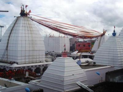
The Baidyanath Jayadurga Shakti Peeth, Deogarh is a prominent Temple dedicated to Goddess Durga located in Deogarh, Haz
Q: What is the total area of Hazaribagh district?
A: The total area of Hazaribagh district is 3555 km².
Q: What is the population of Hazaribagh district according to the 2011 census?
A: According to the 2011 census, the population of Hazaribagh district is 1734495.
Q: How many villages are there in Hazaribagh district?
A: There are approximately 1193 villages in Hazaribagh district.
Q: What is the population density of Hazaribagh district?
A: The population density of Hazaribagh district is 487.9 inhabitants per square kilometre.
Q: How many houses are there in Hazaribagh district?
A: There are about 304749 houses in Hazaribagh district.
Q: How is the Hazaribagh district administratively divided?
A: For administrative purposes, Hazaribagh district is divided into Subdivisions, Blocks, Police Stations (PS), and Community Development Blocks (C.D.Blocks).
Q: What is a C.D.Block in India?
A: A C.D.Block (Community Development Block) is a designated rural area for administration and development in India, managed by a Block Development Officer (BDO) and encompassing several gram panchayats.
Q: Which is the largest Subdivision in Hazaribagh district by area?
A: The largest Subdivision in Hazaribagh district by area is Chauparan, which spans an area of 388 km².
Q: Which is the smallest Subdivision in Hazaribagh district by area?
A: The smallest Subdivision in Hazaribagh district by area is Padma, with an area of 107 km².
Q: Which Subdivision in Hazaribagh district has the largest population?
A: The Subdivision with the largest population in Hazaribagh district is Hazaribag, with a population of 290098 people.
Q: Which Subdivision in Hazaribagh district has the smallest population?
A: The Subdivision with the smallest population in Hazaribagh district is , with a population of 48549 people.
Q: How many Subdivisions are there in Hazaribagh district?
A: There are 16 Subdivisions in Hazaribagh district.
Q: What is the male population of Hazaribagh district?
A: The male population of Hazaribagh district is 20,727.
Q: What is the female population of Hazaribagh district?
A: The female population of Hazaribagh district is 16,115.
Q: How many villages in Hazaribagh district have a population of less than 100?
A: There are 219 villages in Hazaribagh district with a population of less than 100.
Q: How many villages in Hazaribagh district have a population between 100 and 499?
A: There are 299 villages in Hazaribagh district with a population between 100 and 499.
Q: How many villages in Hazaribagh district have a population between 500 and 999?
A: There are 292 villages in Hazaribagh district with a population between 500 and 999.
Q: How many villages in Hazaribagh district have a population between 1000 and 1999?
A: There are 279 villages in Hazaribagh district with a population between 1000 and 1999.
Q: How many villages in Hazaribagh district have a population between 2000 and 2999?
A: There is 110 village in Hazaribagh district with a population between 2000 and 2999.
Q: How many villages in Hazaribagh district have a population between 3000 and 3999?
A: There is 44 village in Hazaribagh district with a population between 3000 and 3999.
Q: How many villages in Hazaribagh district have a population between 4000 and 4999?
A: There is 29 village in Hazaribagh district with a population between 4000 and 4999.
Q: How many villages in Hazaribagh district have a population of 5000 and above?
A: There is 25 village in Hazaribagh district with a population of 5000 and above.
| Total Population | Villages in Sub District Of Hazaribagh |
|---|---|
| Less than 100 | 219 |
| 100-499 | 299 |
| 500-999 | 292 |
| 1000-1999 | 279 |
| 2000-2999 | 110 |
| 3000-3999 | 44 |
| 4000-4999 | 29 |
| 5000 And Above | 25 |