District → Latehar
State → Jharkhand
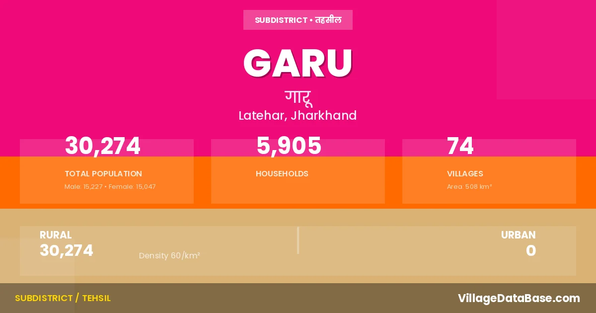
Garu is a town and Subdivision in the Latehar district of the Jharkhand. In India, a Subdivision is a subdivision of a district responsible for the administration and revenue collection of a specific area within the district. Subdivisions play a crucial role in the local governance structure, contributing significantly to the development and administration of their communities.
According to the 2011 census The total area of Garu Subdivision is 508 km², with a population of 30274 people. The population density is 60 inhabitants per square kilometre, and there are approximately 5905 houses in the sub district.
Garu Subdivision comprises about 74 villages. Below is a list of these villages along with information about their respective gram panchayats and the nearest town:
| # | Village Name | Gram Panchayat | Nearest Town |
|---|---|---|---|
| 1 | Alagdiha | Chorha | Garu |
| 2 | Armu Alis Marchaia | Dhangartola | Garu |
| 3 | Baherwa Tola | Karwai | Garu |
| 4 | Baigatoli | Kotam | Garu |
| 5 | Bajajpur | Rud | Garu |
| 6 | Bandua | Chorha | Garu |
| 7 | Baresanr | Baresanr | Garu |
| 8 | Baribandh | Rud | Garu |
| 9 | Bhanwar Bandh | Dhangartola | Garu |
| 10 | Bheriabathan | Ghasitola | Garu |
| 11 | Chanchu | Chorha | Garu |
| 12 | Chanpi | Rud | Garu |
| 13 | Chipru | Ghasitola | Garu |
| 14 | Chiraiya | Rud | Garu |
| 15 | Chorha | Chorha | Garu |
| 16 | Dabri | Chorha | Garu |
| 17 | Daldalia | Karwai | Garu |
| 18 | Danrkocha | Mayapur | Garu |
| 19 | Darichhapar | Rud | Garu |
| 20 | Derhganw | Baresanr | Garu |
| 21 | Dhangar Tola | Dhangartola | Garu |
| 22 | Doram | Ghasitola | Garu |
| 23 | Garu | Dhangartola | Garu |
| 24 | Gasigara | Chorha | Garu |
| 25 | Ghasitola | Ghasitola | Garu |
| 26 | Ghuturu | Rud | Garu |
| 27 | Goendi | Karwai | Garu |
| 28 | Gopi Khonr | Rud | Garu |
| 29 | Gotag | Chorha | Garu |
| 30 | Hanumantola | Ghasitola | Garu |
| 31 | Hendehas | Rud | Garu |
| 32 | Hesag | Dhangartola | Garu |
| 33 | Hethtola | Karwai | Garu |
| 34 | Hurdag | Kotam | Garu |
| 35 | Kabri | Rud | Garu |
| 36 | Kante | Rud | Garu |
| 37 | Karihenar | Baresanr | Garu |
| 38 | Karitola | Ghasitola | Garu |
| 39 | Karwai | Karwai | Garu |
| 40 | Kojram | Baresanr | Garu |
| 41 | Korwatola | Ghasitola | Garu |
| 42 | Kotam | Kotam | Garu |
| 43 | Kui | Karwai | Garu |
| 44 | Lai | Chorha | Garu |
| 45 | Latu | Baresanr | Garu |
| 46 | Lohargara | Karwai | Garu |
| 47 | Luhurtanr | Dhangartola | Garu |
| 48 | Mahuadabar | Rud | Garu |
| 49 | Makundpur | Ghasitola | Garu |
| 50 | Mangra | Baresanr | Garu |
| 51 | Maromar | Dhangartola | Garu |
| 52 | Mayapur | Mayapur | Garu |
| 53 | Murpa | Chorha | Garu |
| 54 | Paharkocha | Mayapur | Garu |
| 55 | Pailapathal | Chorha | Garu |
| 56 | Pandra | Rud | Garu |
| 57 | Pati | Rud | Garu |
| 58 | Patratu | Ghasitola | Garu |
| 59 | Piri | Ghasitola | Garu |
| 60 | Purnaki Dabri | Chorha | Garu |
| 61 | Purni Armu | Dhangartola | Garu |
| 62 | Purni Hesag | Dhangartola | Garu |
| 63 | Ramseli | Mayapur | Garu |
| 64 | Rol | Ghasitola | Garu |
| 65 | Rud | Rud | Garu |
| 66 | Salwe | Kotam | Garu |
| 67 | Samodh Tola | Dhangartola | Garu |
| 68 | Sarju | Chorha | Garu |
| 69 | Sima Khas | Rud | Garu |
| 70 | Siram | Kotam | Garu |
| 71 | Sonwar | Ghasitola | Garu |
| 72 | Surkumi | Dhangartola | Garu |
| 73 | Tola Hurdag Alias Chirodih | Karwai | Garu |
| 74 | Udaipur | Ghasitola | Garu |
The population is distributed between urban and rural areas as follows:
| Particulars | Rural | Urban | Total |
|---|---|---|---|
| Total Population | 30274 | 0 | 30274 |
| Male Population | 15227 | 0 | 15227 |
| Female Population | 15047 | 0 | 15047 | Population Density | 60 / km² | 60 / km² |
The distribution of households in the Garu is:
| Rural Households | Urban Households | Total Households |
|---|---|---|
| 5905 | 0 | 5905 |
Q: What is Garu?
A: Garu is a town and in the Latehar district of the Jharkhand.
Q: What is the total area of Garu Subdivision?
A: The total area of Garu Subdivision is 508 km².
Q: What is the population of Garu Subdivision according to the 2011 census?
A: According to the 2011 census, the population of Garu Subdivision is 30274.
Q: What is the population density of Garu Subdivision?
A: The population density of Garu Subdivision is 60 inhabitants per square kilometre.
Q: How many houses are there in Garu Subdivision?
A: There are approximately 5905 houses in Garu Subdivision.
Q: How many villages are there in Garu Subdivision?
A: There are about 74 villages in Garu Subdivision.
Q: Which is the largest village by population in Garu Subdivision?
A: The largest village by population in Garu Subdivision is Dhangar Tola, with 1558 people.
Q: Which is the smallest village by population in Garu Subdivision?
A: The smallest village by population in Garu Subdivision is Bheriabathan, with 0 people.
Q: Which is the largest village by area in Garu Subdivision?
A: The largest village by area in Garu Subdivision is Surkumi, with 1368 km².
Q: Which is the smallest village by area in Garu Subdivision?
A: The smallest village by area in Garu Subdivision is Kojram, with 0 km².
Q: What is the population distribution between urban and rural areas in Garu Subdivision?
A: The population distribution in Garu Subdivision is entirely rural, with a total rural population of 30274.
Q: What is the male population of Garu Subdivision?
A: The male population of Garu Subdivision is 15227.
Q: What is the female population of Garu Subdivision?
A: The female population of Garu Subdivision is 15047.
Q: How is the household distribution in Garu Subdivision?
A: The household distribution in Garu Subdivision is entirely rural, with a total of 5905 households.
Q: How many villages in Garu Subdivision have a population of less than 100?
A: There are 8 villages in Garu Subdivision with a population of less than 100.
Q: How many villages in Garu Subdivision have a population between 100 and 499?
A: There are 43 villages in Garu Subdivision with a population between 100 and 499.
Q: How many villages in Garu Subdivision have a population between 500 and 999?
A: There are 18 villages in Garu Subdivision with a population between 500 and 999.
Q: How many villages in Garu Subdivision have a population between 1000 and 1999?
A: There are 5 villages in Garu Subdivision with a population between 1000 and 1999.
| Total Population | Villages in Sub District Of Garu |
|---|---|
| Less than 100 | 8 |
| 100-499 | 43 |
| 500-999 | 18 |
| 1000-1999 | 5 |