District → Palamu
State → Jharkhand
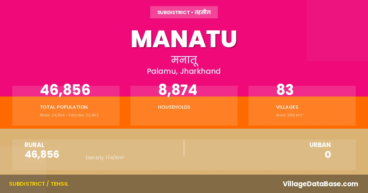
Manatu is a town and Subdivision in the Palamu district of the Jharkhand. In India, a Subdivision is a subdivision of a district responsible for the administration and revenue collection of a specific area within the district. Subdivisions play a crucial role in the local governance structure, contributing significantly to the development and administration of their communities.
According to the 2011 census The total area of Manatu Subdivision is 269 km², with a population of 46856 people. The population density is 174 inhabitants per square kilometre, and there are approximately 8874 houses in the sub district.
Manatu Subdivision comprises about 83 villages. Below is a list of these villages along with information about their respective gram panchayats and the nearest town:
| # | Village Name | Gram Panchayat | Nearest Town |
|---|---|---|---|
| 1 | Abduldih | Padama | Manatu |
| 2 | Adauriya | Chak | Manatu |
| 3 | Apti | Dumari | Manatu |
| 4 | Banasam Alias Murdhoi | Manjhauli A | Manatu |
| 5 | Bansikhurd | Banshikhurd | Manatu |
| 6 | Baskatia | Dumari | Manatu |
| 7 | Bhainsasur | Padama | Manatu |
| 8 | Bhitdiha | Padama | Manatu |
| 9 | Bhitiahi | Banshikhurd | Manatu |
| 10 | Bhitkila | Dumari | Manatu |
| 11 | Bihra | Manjhauli A | Manatu |
| 12 | Birhorwa | Rangeya | Manatu |
| 13 | Bisranw | Dumari | Manatu |
| 14 | Budhandih | Padama | Manatu |
| 15 | Chak | Chak | Manatu |
| 16 | Chanpi | Chak | Manatu |
| 17 | Chiri Khurd | Dumari | Manatu |
| 18 | Chunka | Rangeya | Manatu |
| 19 | Daldalia | Dumari | Manatu |
| 20 | Dewdih | Banshikhurd | Manatu |
| 21 | Dhanibigha | Manjhauli A | Manatu |
| 22 | Dhumkhar | Chak | Manatu |
| 23 | Dumri | Dumari | Manatu |
| 24 | Garhganw | Rangeya | Manatu |
| 25 | Garhwat | Naudiha | Daltenganj |
| 26 | Garwat | Dumari | Manatu |
| 27 | Gauhi | Banshikhurd | Manatu |
| 28 | Gaurwatanr | Banshikhurd | Manatu |
| 29 | Ghanghri | Naudiha | Daltenganj |
| 30 | Ghirsiri | Rangeya | Manatu |
| 31 | Jagirha | Banshikhurd | Manatu |
| 32 | Jaleya | Chak | Manatu |
| 33 | Jaspur | Manjhauli A | Manatu |
| 34 | Jhanti | Dumari | Manatu |
| 35 | Kairadih | Padama | Manatu |
| 36 | Karaila | Naudiha | Daltenganj |
| 37 | Karma | Kasmar | Manatu |
| 38 | Karma Alias Tilha | Naudiha | Daltenganj |
| 39 | Karmahi | Chak | Manatu |
| 40 | Karwat | Dumari | Manatu |
| 41 | Kasha | Banshikhurd | Manatu |
| 42 | Kedal | Dumari | Manatu |
| 43 | Kekrahi | Rangeya | Manatu |
| 44 | Khaira | Manjhauli A | Manatu |
| 45 | Kharikdag | Rangeya | Manatu |
| 46 | Korda | Dumari | Manatu |
| 47 | Kundilpur | Rangeya | Manatu |
| 48 | Kusri | Manjhauli A | Manatu |
| 49 | Madheya | Naudiha | Daltenganj |
| 50 | Maghouli | Manjhauli A | Manatu |
| 51 | Manatu | Manjhauli A | Manatu |
| 52 | Masuria | Rangeya | Manatu |
| 53 | Mitar | Dumari | Manatu |
| 54 | Morainia | Dumari | Manatu |
| 55 | Mukta | Manjhauli A | Manatu |
| 56 | Nagad | Dumari | Manatu |
| 57 | Naudiha | Naudiha | Daltenganj |
| 58 | Nawa | Rangeya | Manatu |
| 59 | Paduma | Padama | Manatu |
| 60 | Pakariadih | Padama | Manatu |
| 61 | Pannadih | Padama | Manatu |
| 62 | Pasiya | Chak | Manatu |
| 63 | Patra | Rangeya | Manatu |
| 64 | Purnadih | Dumari | Manatu |
| 65 | Rabda | Manjhauli A | Manatu |
| 66 | Rahea | Naudiha | Manatu |
| 67 | Rajkheta | Rangeya | Manatu |
| 68 | Rangeya | Rangeya | Manatu |
| 69 | Semri | Naudiha | Daltenganj |
| 70 | Sikda | Dumari | Manatu |
| 71 | Sikni | Arka | Manatu |
| 72 | Sildag | Dumari | Manatu |
| 73 | Sildiliya Khurd | Banshikhurd | Manatu |
| 74 | Sohe | Dumari | Manatu |
| 75 | Surgiya | Rangeya | Manatu |
| 76 | Tanrwa | Rangeya | Manatu |
| 77 | Teliyadohar | Padama | Manatu |
| 78 | Tetar | Manjhauli A | Manatu |
| 79 | Tetardih | Padama | Manatu |
| 80 | Tilha | Chak | Manatu |
| 81 | Tilo | Naudiha | Daltenganj |
| 82 | Turiadih | Rangeya | Manatu |
| 83 | Urur | Chak | Manatu |
The population is distributed between urban and rural areas as follows:
| Particulars | Rural | Urban | Total |
|---|---|---|---|
| Total Population | 46856 | 0 | 46856 |
| Male Population | 24394 | 0 | 24394 |
| Female Population | 22462 | 0 | 22462 | Population Density | 174 / km² | 174 / km² |
The distribution of households in the Manatu is:
| Rural Households | Urban Households | Total Households |
|---|---|---|
| 8874 | 0 | 8874 |
Q: What is Manatu?
A: Manatu is a town and in the Palamu district of the Jharkhand.
Q: What is the total area of Manatu Subdivision?
A: The total area of Manatu Subdivision is 269 km².
Q: What is the population of Manatu Subdivision according to the 2011 census?
A: According to the 2011 census, the population of Manatu Subdivision is 46856.
Q: What is the population density of Manatu Subdivision?
A: The population density of Manatu Subdivision is 174 inhabitants per square kilometre.
Q: How many houses are there in Manatu Subdivision?
A: There are approximately 8874 houses in Manatu Subdivision.
Q: How many villages are there in Manatu Subdivision?
A: There are about 83 villages in Manatu Subdivision.
Q: Which is the largest village by population in Manatu Subdivision?
A: The largest village by population in Manatu Subdivision is Chak, with 3027 people.
Q: Which is the smallest village by population in Manatu Subdivision?
A: The smallest village by population in Manatu Subdivision is Bhitiahi, with 0 people.
Q: Which is the largest village by area in Manatu Subdivision?
A: The largest village by area in Manatu Subdivision is Tanrwa, with 2083 km².
Q: Which is the smallest village by area in Manatu Subdivision?
A: The smallest village by area in Manatu Subdivision is Dhanibigha, with 20 km².
Q: What is the population distribution between urban and rural areas in Manatu Subdivision?
A: The population distribution in Manatu Subdivision is entirely rural, with a total rural population of 46856.
Q: What is the male population of Manatu Subdivision?
A: The male population of Manatu Subdivision is 24394.
Q: What is the female population of Manatu Subdivision?
A: The female population of Manatu Subdivision is 22462.
Q: How is the household distribution in Manatu Subdivision?
A: The household distribution in Manatu Subdivision is entirely rural, with a total of 8874 households.
Q: How many villages in Manatu Subdivision have a population of less than 100?
A: There are 14 villages in Manatu Subdivision with a population of less than 100.
Q: How many villages in Manatu Subdivision have a population between 100 and 499?
A: There are 28 villages in Manatu Subdivision with a population between 100 and 499.
Q: How many villages in Manatu Subdivision have a population between 500 and 999?
A: There are 29 villages in Manatu Subdivision with a population between 500 and 999.
Q: How many villages in Manatu Subdivision have a population between 1000 and 1999?
A: There are 11 villages in Manatu Subdivision with a population between 1000 and 1999.
Q: How many villages in Manatu Subdivision have a population between 3000 and 3999?
A: There is 1 village in Manatu Subdivision with a population between 3000 and 3999.
| Total Population | Villages in Sub District Of Manatu |
|---|---|
| Less than 100 | 14 |
| 100-499 | 28 |
| 500-999 | 29 |
| 1000-1999 | 11 |
| 3000-3999 | 1 |