District → Ramgarh
State → Jharkhand
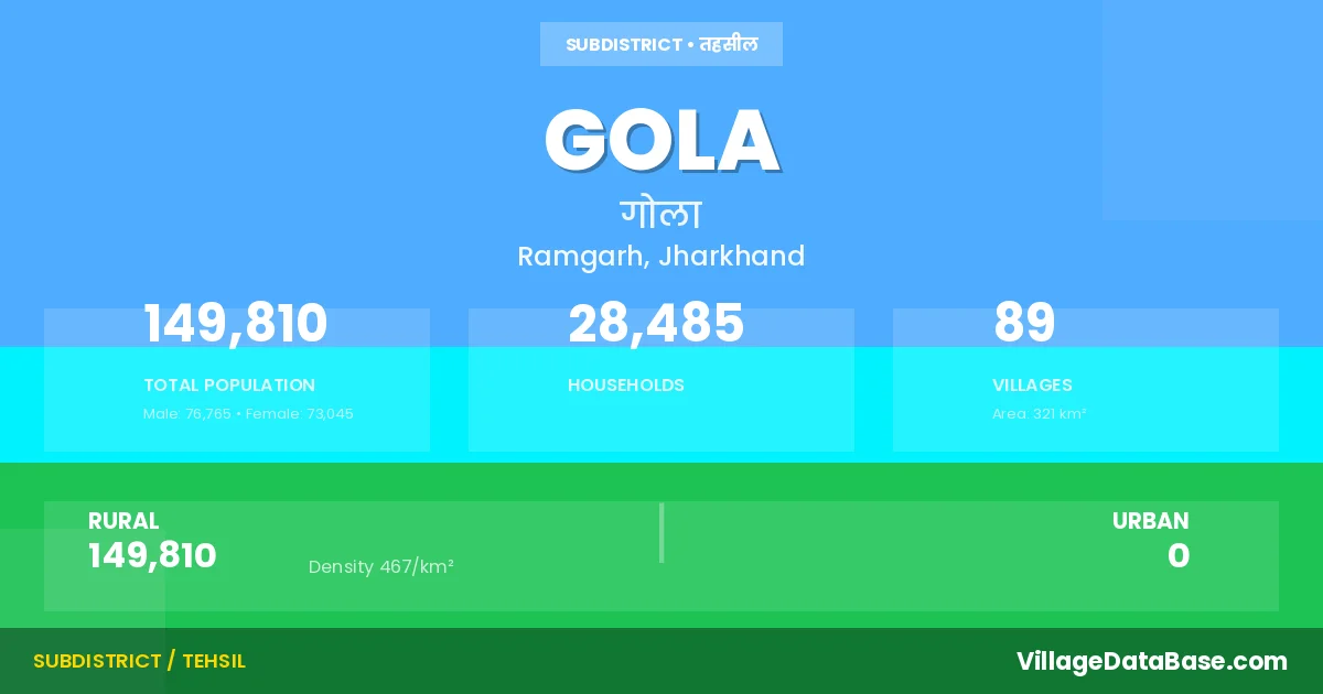
Gola is a town and Subdivision in the Ramgarh district of the Jharkhand. In India, a Subdivision is a subdivision of a district responsible for the administration and revenue collection of a specific area within the district. Subdivisions play a crucial role in the local governance structure, contributing significantly to the development and administration of their communities.
According to the 2011 census The total area of Gola Subdivision is 321 km², with a population of 149810 people. The population density is 467 inhabitants per square kilometre, and there are approximately 28485 houses in the sub district.
Gola Subdivision comprises about 89 villages. Below is a list of these villages along with information about their respective gram panchayats and the nearest town:
| # | Village Name | Gram Panchayat | Nearest Town |
|---|---|---|---|
| 1 | Alagdiha | Bariatu | Gola |
| 2 | Aonradih | Uparbarga | Gola |
| 3 | Bagha Kudar | Purabdih | Gola |
| 4 | Bamhan Sagatu | Sutri | Gola |
| 5 | Banda | Banda | Gola |
| 6 | Bantara | Purabdih | Gola |
| 7 | Bardiha | Bariatu | Gola |
| 8 | Bargutu | Purabdih | Gola |
| 9 | Bariatu | Bariatu | Gola |
| 10 | Barki Koiya | Bariatu | Gola |
| 11 | Barki Sarla | Sangrampur | Gola |
| 12 | Barlanga | Barlanga | Gola |
| 13 | Betul Kalan | Betulkala | Gola |
| 14 | Betul Khurd | Betulkala | Gola |
| 15 | Bhubhui | Hesapoda | Gola |
| 16 | Bhuinya Sagatu | Sutri | Gola |
| 17 | Bisa | Betulkala | Gola |
| 18 | Biyang | Huppu | Gola |
| 19 | Chakarbali | Chokad | Gola |
| 20 | Chari | Chadi | Gola |
| 21 | Chhotki Koiya | Bariatu | Gola |
| 22 | Chokad | Chokad | Gola |
| 23 | Chopadaru | Chokad | Gola |
| 24 | Dabhatu | Purabdih | Gola |
| 25 | Dhamnatanr Alias Mahadeokuda | Sosokala | Gola |
| 26 | Dimra | Saragdih | Gola |
| 27 | Dundigachhi | Chokad | Gola |
| 28 | Gandhaunia | Rakua | Gola |
| 29 | Ghaghra | Korambe | Gola |
| 30 | Ghasi Kenke | Chadi | Gola |
| 31 | Gobindpur | Nawadih | Gola |
| 32 | Gola | Gola | Gola |
| 33 | Hariband | Chadi | Gola |
| 34 | Hematpur | Sosokala | Gola |
| 35 | Heramdaga | Chadi | Gola |
| 36 | Hesal | Korambe | Gola |
| 37 | Hesapora | Hesapoda | Gola |
| 38 | Hethbarga | Barlanga | Gola |
| 39 | Hisimdag | Sosokala | Gola |
| 40 | Homasita | Sadam | Gola |
| 41 | Hulu | Sangrampur | Gola |
| 42 | Hupu | Huppu | Gola |
| 43 | Jabhia | Chadi | Gola |
| 44 | Jamuna | Purabdih | Gola |
| 45 | Jangi | Maganpur | Gola |
| 46 | Kamta | Bariatu | Gola |
| 47 | Kamti | Bariatu | Gola |
| 48 | Kenke | Huppu | Gola |
| 49 | Khakhra | Chokad | Gola |
| 50 | Khokha | Huppu | Gola |
| 51 | Koenardih | Korambe | Gola |
| 52 | Korambe | Korambe | Gola |
| 53 | Kuju Kalan | Sadam | Gola |
| 54 | Kumhardaga | Purabdih | Gola |
| 55 | Kusumdih Kalyanpur | Chadi | Gola |
| 56 | Lipia | Rakua | Gola |
| 57 | Maganpur | Maganpur | Gola |
| 58 | Mahalidih | Maganpur | Gola |
| 59 | Mundudih | Sangrampur | Gola |
| 60 | Murmuta | Banda | Gola |
| 61 | Murpa | Banda | Gola |
| 62 | Nawa Sirka | Huppu | Gola |
| 63 | Nawadih | Bariatu | Gola |
| 64 | Patratu | Betulkala | Gola |
| 65 | Purabdih Alias Kudapalu | Purabdih | Gola |
| 66 | Purna Sirka | Huppu | Gola |
| 67 | Raipura | Purabdih | Gola |
| 68 | Rakua | Rakua | Gola |
| 69 | Raorao | Uparbarga | Gola |
| 70 | Rola | Sutri | Gola |
| 71 | Rundai | Bariatu | Gola |
| 72 | Sagrampur | Sangrampur | Gola |
| 73 | Saragdih | Saragdih | Gola |
| 74 | Saram | Sadam | Gola |
| 75 | Sarla Khurd | Sangrampur | Gola |
| 76 | Sereghatu | Sadam | Gola |
| 77 | Sitinghatu | Bariatu | Gola |
| 78 | Sokla | Saragdih | Gola |
| 79 | Sondimra | Nawadih | Gola |
| 80 | Soso Kalan | Sosokala | Gola |
| 81 | Soso Khurd | Sosokala | Gola |
| 82 | Sothai | Bariatu | Gola |
| 83 | Sutri | Sutri | Gola |
| 84 | Tandil | Betulkala | Gola |
| 85 | Tirla | Kumhardaga | Gola |
| 86 | Tonagatu | Sadam | Gola |
| 87 | Toyar | Huppu | Gola |
| 88 | Uladaka | Saragdih | Gola |
| 89 | Uparbarga | Uparbarga | Gola |
The population is distributed between urban and rural areas as follows:
| Particulars | Rural | Urban | Total |
|---|---|---|---|
| Total Population | 149810 | 0 | 149810 |
| Male Population | 76765 | 0 | 76765 |
| Female Population | 73045 | 0 | 73045 | Population Density | 467 / km² | 467 / km² |
The distribution of households in the Gola is:
| Rural Households | Urban Households | Total Households |
|---|---|---|
| 28485 | 0 | 28485 |
Q: What is Gola?
A: Gola is a town and in the Ramgarh district of the Jharkhand.
Q: What is the total area of Gola Subdivision?
A: The total area of Gola Subdivision is 321 km².
Q: What is the population of Gola Subdivision according to the 2011 census?
A: According to the 2011 census, the population of Gola Subdivision is 149810.
Q: What is the population density of Gola Subdivision?
A: The population density of Gola Subdivision is 467 inhabitants per square kilometre.
Q: How many houses are there in Gola Subdivision?
A: There are approximately 28485 houses in Gola Subdivision.
Q: How many villages are there in Gola Subdivision?
A: There are about 89 villages in Gola Subdivision.
Q: Which is the largest village by population in Gola Subdivision?
A: The largest village by population in Gola Subdivision is Gola, with 8076 people.
Q: Which is the smallest village by population in Gola Subdivision?
A: The smallest village by population in Gola Subdivision is Alagdiha, with 0 people.
Q: Which is the largest village by area in Gola Subdivision?
A: The largest village by area in Gola Subdivision is Saram, with 1439 km².
Q: Which is the smallest village by area in Gola Subdivision?
A: The smallest village by area in Gola Subdivision is Sitinghatu, with 20 km².
Q: What is the population distribution between urban and rural areas in Gola Subdivision?
A: The population distribution in Gola Subdivision is entirely rural, with a total rural population of 149810.
Q: What is the male population of Gola Subdivision?
A: The male population of Gola Subdivision is 76765.
Q: What is the female population of Gola Subdivision?
A: The female population of Gola Subdivision is 73045.
Q: How is the household distribution in Gola Subdivision?
A: The household distribution in Gola Subdivision is entirely rural, with a total of 28485 households.
Q: How many villages in Gola Subdivision have a population of less than 100?
A: There are 6 villages in Gola Subdivision with a population of less than 100.
Q: How many villages in Gola Subdivision have a population between 100 and 499?
A: There are 12 villages in Gola Subdivision with a population between 100 and 499.
Q: How many villages in Gola Subdivision have a population between 500 and 999?
A: There are 16 villages in Gola Subdivision with a population between 500 and 999.
Q: How many villages in Gola Subdivision have a population between 1000 and 1999?
A: There are 32 villages in Gola Subdivision with a population between 1000 and 1999.
Q: How many villages in Gola Subdivision have a population between 2000 and 2999?
A: There is 9 village in Gola Subdivision with a population between 2000 and 2999.
Q: How many villages in Gola Subdivision have a population between 3000 and 3999?
A: There is 11 village in Gola Subdivision with a population between 3000 and 3999.
Q: How many villages in Gola Subdivision have a population between 4000 and 4999?
A: There is 1 village in Gola Subdivision with a population between 4000 and 4999.
Q: How many villages in Gola Subdivision have a population of 5000 and above?
A: There is 2 village in Gola Subdivision with a population of 5000 and above.
| Total Population | Villages in Sub District Of Gola |
|---|---|
| Less than 100 | 6 |
| 100-499 | 12 |
| 500-999 | 16 |
| 1000-1999 | 32 |
| 2000-2999 | 9 |
| 3000-3999 | 11 |
| 4000-4999 | 1 |
| 5000 And Above | 2 |