District → Ranchi
State → Jharkhand
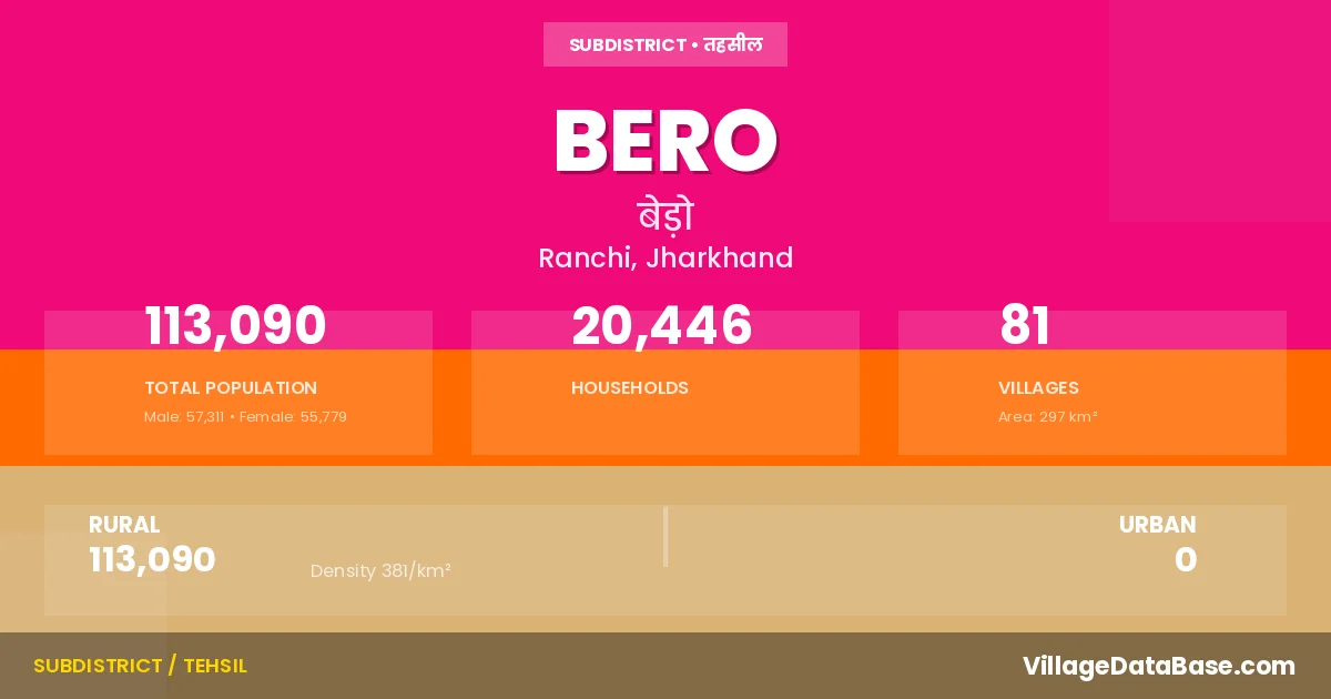
Bero is a town and Subdivision in the Ranchi district of the Jharkhand. In India, a Subdivision is a subdivision of a district responsible for the administration and revenue collection of a specific area within the district. Subdivisions play a crucial role in the local governance structure, contributing significantly to the development and administration of their communities.
According to the 2011 census The total area of Bero Subdivision is 297 km², with a population of 113090 people. The population density is 381 inhabitants per square kilometre, and there are approximately 20446 houses in the sub district.
Bero Subdivision comprises about 81 villages. Below is a list of these villages along with information about their respective gram panchayats and the nearest town:
| # | Village Name | Gram Panchayat | Nearest Town |
|---|---|---|---|
| 1 | Asro | Ghaghra | Bero |
| 2 | Baid Khijri | Doranda | Ranchi |
| 3 | Balirampur | Tutlo | Bero |
| 4 | Banri | Tero | Bero |
| 5 | Baridih | Bero | Bero |
| 6 | Bero | Bero | Bero |
| 7 | Bhainsadon | Karkari | Bero |
| 8 | Bhasnanda | Hariharpur Jamtoli | Bero |
| 9 | Bilti | Doranda | Ranchi |
| 10 | Boda | Hariharpur Jamtoli | Bero |
| 11 | Chachkapi | Murto | Bero |
| 12 | Changani | Chachkapi | Bero |
| 13 | Chanho | Tutlo | Bero |
| 14 | Chankapi | Khukhra | Bero |
| 15 | Chapadih | Tutlo | Bero |
| 16 | Charma | Ita | Ranchi |
| 17 | Childiri | Ita | Bero |
| 18 | Darsita | Tutlo | Bero |
| 19 | Dighiya | Dighia | Bero |
| 20 | Donrkanrriya | Murto | Bero |
| 21 | Doranda | Doranda | Bero |
| 22 | Dumardon | Ghaghra | Bero |
| 23 | Dumri | Nehalukapariya | Ranchi |
| 24 | Duru | Chachkapi | Ranchi |
| 25 | Garri | Nehalukapariya | Bero |
| 26 | Ghaghra | Ghaghra | Bero |
| 27 | Harhanji | Hariharpur Jamtoli | Harhanji |
| 28 | Hariharpur Jamtoli | Hariharpur Jamtoli | Bero |
| 29 | Hathu | Ita | Ranchi |
| 30 | Hulsi | Jaria | Bero |
| 31 | Hutar | Hariharpur Jamtoli | Hutar |
| 32 | Hutri | Ita | Ranchi |
| 33 | Irri | Tero | Bero |
| 34 | Ita | Ita | Bero |
| 35 | Jahanabaj | Hariharpur Jamtoli | Bero |
| 36 | Jamuni | Hariharpur Jamtoli | Bero |
| 37 | Jariya | Jaria | Ranchi |
| 38 | Kadojora | Ita | Bero |
| 39 | Kairo | Ghaghra | Bero |
| 40 | Karanji | Karanji | Bero |
| 41 | Karge | Doranda | Ranchi |
| 42 | Karkari | Karkari | Bero |
| 43 | Katarmali | Jaria | Bero |
| 44 | Kerabhita | Nehalukapariya | Ranchi |
| 45 | Kesa | Kesha | Bero |
| 46 | Khanrdiuri | Karkari | Bero |
| 47 | Khatanga | Karanji | Bero |
| 48 | Khirda | Ita | Bero |
| 49 | Khukhra | Khukhra | Bero |
| 50 | Konkre | Ghaghra | Bero |
| 51 | Kotpali | Tutlo | Bero |
| 52 | Kudarko | Tero | Ranchi |
| 53 | Lamkara | Ita | Bero |
| 54 | Madhupur | Ghaghra | Bero |
| 55 | Mahru | Hariharpur Jamtoli | Bero |
| 56 | Mahugaon | Tero | Bero |
| 57 | Makunda | Karkari | Bero |
| 58 | Masiatu | Tutlo | Bero |
| 59 | Masu | Jaria | Bero |
| 60 | Muramu | Jaria | Bero |
| 61 | Murto | Murto | Bero |
| 62 | Nagri | Karanji | Bero |
| 63 | Nari | Kesha | Bero |
| 64 | Narkopi | Karkari | Bero |
| 65 | Nehalukapariya | Nehalukapariya | Ranchi |
| 66 | Paharkanrriya | Murto | Bero |
| 67 | Pandra | Hariharpur Jamtoli | Bero |
| 68 | Puriya | Purio | Bero |
| 69 | Roghadihpatratoli | Nehalukapariya | Ranchi |
| 70 | Rogo | Nehalukapariya | Ranchi |
| 71 | Rora Alias Garhatoli | Chachkapi | Bero |
| 72 | Semra | Kurgi | Bero |
| 73 | Sero | Doranda | Ranchi |
| 74 | Sijhuwa | Ghaghra | Bero |
| 75 | Singarsarai | Ghaghra | Bero |
| 76 | Suartoli | Ghaghra | Bero |
| 77 | Tengriya | Dighia | Bero |
| 78 | Tero | Tero | Bero |
| 79 | Tikratoli | Kesha | Bero |
| 80 | Tuko | Dighia | Bero |
| 81 | Tutlo | Tutlo | Bero |
The population is distributed between urban and rural areas as follows:
| Particulars | Rural | Urban | Total |
|---|---|---|---|
| Total Population | 113090 | 0 | 113090 |
| Male Population | 57311 | 0 | 57311 |
| Female Population | 55779 | 0 | 55779 | Population Density | 381 / km² | 381 / km² |
The distribution of households in the Bero is:
| Rural Households | Urban Households | Total Households |
|---|---|---|
| 20446 | 0 | 20446 |
Q: What is Bero?
A: Bero is a town and in the Ranchi district of the Jharkhand.
Q: What is the total area of Bero Subdivision?
A: The total area of Bero Subdivision is 297 km².
Q: What is the population of Bero Subdivision according to the 2011 census?
A: According to the 2011 census, the population of Bero Subdivision is 113090.
Q: What is the population density of Bero Subdivision?
A: The population density of Bero Subdivision is 381 inhabitants per square kilometre.
Q: How many houses are there in Bero Subdivision?
A: There are approximately 20446 houses in Bero Subdivision.
Q: How many villages are there in Bero Subdivision?
A: There are about 81 villages in Bero Subdivision.
Q: Which is the largest village by population in Bero Subdivision?
A: The largest village by population in Bero Subdivision is Bero, with 7193 people.
Q: Which is the smallest village by population in Bero Subdivision?
A: The smallest village by population in Bero Subdivision is Suartoli, with 135 people.
Q: Which is the largest village by area in Bero Subdivision?
A: The largest village by area in Bero Subdivision is Nehalukapariya, with 1547 km².
Q: Which is the smallest village by area in Bero Subdivision?
A: The smallest village by area in Bero Subdivision is Madhupur, with 29 km².
Q: What is the population distribution between urban and rural areas in Bero Subdivision?
A: The population distribution in Bero Subdivision is entirely rural, with a total rural population of 113090.
Q: What is the male population of Bero Subdivision?
A: The male population of Bero Subdivision is 57311.
Q: What is the female population of Bero Subdivision?
A: The female population of Bero Subdivision is 55779.
Q: How is the household distribution in Bero Subdivision?
A: The household distribution in Bero Subdivision is entirely rural, with a total of 20446 households.
Q: How many villages in Bero Subdivision have a population between 100 and 499?
A: There are 14 villages in Bero Subdivision with a population between 100 and 499.
Q: How many villages in Bero Subdivision have a population between 500 and 999?
A: There are 28 villages in Bero Subdivision with a population between 500 and 999.
Q: How many villages in Bero Subdivision have a population between 1000 and 1999?
A: There are 21 villages in Bero Subdivision with a population between 1000 and 1999.
Q: How many villages in Bero Subdivision have a population between 2000 and 2999?
A: There is 12 village in Bero Subdivision with a population between 2000 and 2999.
Q: How many villages in Bero Subdivision have a population between 3000 and 3999?
A: There is 3 village in Bero Subdivision with a population between 3000 and 3999.
Q: How many villages in Bero Subdivision have a population between 4000 and 4999?
A: There is 1 village in Bero Subdivision with a population between 4000 and 4999.
Q: How many villages in Bero Subdivision have a population of 5000 and above?
A: There is 2 village in Bero Subdivision with a population of 5000 and above.
| Total Population | Villages in Sub District Of Bero |
|---|---|
| 100-499 | 14 |
| 500-999 | 28 |
| 1000-1999 | 21 |
| 2000-2999 | 12 |
| 3000-3999 | 3 |
| 4000-4999 | 1 |
| 5000 And Above | 2 |