District → Ranchi
State → Jharkhand
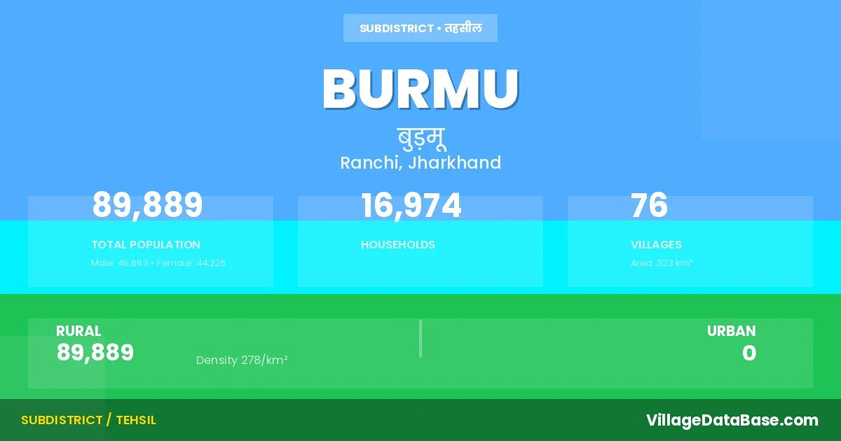
Burmu is a town and Subdivision in the Ranchi district of the Jharkhand. In India, a Subdivision is a subdivision of a district responsible for the administration and revenue collection of a specific area within the district. Subdivisions play a crucial role in the local governance structure, contributing significantly to the development and administration of their communities.
According to the 2011 census The total area of Burmu Subdivision is 323 km², with a population of 89889 people. The population density is 278 inhabitants per square kilometre, and there are approximately 16974 houses in the sub district.
Burmu Subdivision comprises about 76 villages. Below is a list of these villages along with information about their respective gram panchayats and the nearest town:
| # | Village Name | Gram Panchayat | Nearest Town |
|---|---|---|---|
| 1 | Aktan | Sarle | Ranchi |
| 2 | Anatu | Chaingara | Ranchi |
| 3 | Ara | Ojhasaram | Ranchi |
| 4 | Arid | Sarle | Ranchi |
| 5 | Arra | Gurgain | Ranchi |
| 6 | Bangaon | Burmu | Ranchi |
| 7 | Baraudi | Khakhra | Ranchi |
| 8 | Bare | Bade | Ranchi |
| 9 | Barkamuru | Umedanda | Ranchi |
| 10 | Basri | Khakhra | Ranchi |
| 11 | Berwari | Hesalpiri | Ranchi |
| 12 | Bhantboreya | Khakhra | Ranchi |
| 13 | Binja | Chapper | Ranchi |
| 14 | Burmu | Burmu | Ranchi |
| 15 | Chaingara | Chaingara | Ranchi |
| 16 | Chakme | Chakme | Ranchi |
| 17 | Chalniya | Umedanda | Ranchi |
| 18 | Chanya | Murupiri | Ranchi |
| 19 | Chapra | Chapper | Ranchi |
| 20 | Churugara | Chapper | Ranchi |
| 21 | Dandiya | Bade | Ranchi |
| 22 | Erud | Umedanda | Ranchi |
| 23 | Geswe | Chaingara | Ranchi |
| 24 | Ginjothakurgaon | Ginjothakurgaon | Ranchi |
| 25 | Gurgain | Gurgain | Ranchi |
| 26 | Gutru | Chaingara | Ranchi |
| 27 | Hatnai | Burmu | Ranchi |
| 28 | Hendag | Chapper | Ranchi |
| 29 | Hering | Chapper | Ranchi |
| 30 | Hesalpiri | Hesalpiri | Ranchi |
| 31 | Hisri | Khakhra | Ranchi |
| 32 | Hutpai | Makka | Ranchi |
| 33 | Ichapiri | Makka | Ranchi |
| 34 | Ithe | Gurgain | Ranchi |
| 35 | Kanadih | Makka | Ranchi |
| 36 | Kander | Sarle | Ranchi |
| 37 | Karamba | Ojhasaram | Ranchi |
| 38 | Kaskoma | Murupiri | Ranchi |
| 39 | Katangdiri | Chaingara | Ranchi |
| 40 | Kedli | Makka | Ranchi |
| 41 | Kewtia | Khakhra | Ranchi |
| 42 | Khakhra | Khakhra | Ranchi |
| 43 | Koejam | Sarle | Ranchi |
| 44 | Korabar | Hesalpiri | Ranchi |
| 45 | Kori | Chaingara | Ranchi |
| 46 | Kotari | Burmu | Ranchi |
| 47 | Kulwe | Bade | Ranchi |
| 48 | Lawagara | Chaingara | Ranchi |
| 49 | Lothmana | Ojhasaram | Ranchi |
| 50 | Makka | Makka | Ranchi |
| 51 | Manatu | Hesalpiri | Ranchi |
| 52 | Matwe | Chakme | Ranchi |
| 53 | Mohanpur | Gurgain | Ranchi |
| 54 | Muna | Ojhasaram | Ranchi |
| 55 | Murgi | Murupiri | Ranchi |
| 56 | Murumgara | Gurgain | Ranchi |
| 57 | Murupiri | Murupiri | Ranchi |
| 58 | Murwe | Burmu | Ranchi |
| 59 | Nauj | Bade | Ranchi |
| 60 | Ojhasaram | Ojhasaram | Ranchi |
| 61 | Patkai | Murupiri | Ranchi |
| 62 | Piraguttu | Burmu | Ranchi |
| 63 | Rol | Chakme | Ranchi |
| 64 | Salhan | Chaingara | Ranchi |
| 65 | Saram | Ojhasaram | Ranchi |
| 66 | Sarle | Sarle | Ranchi |
| 67 | Sidraul | Bade | Ranchi |
| 68 | Siram | Makka | Ranchi |
| 69 | Soba | Hesalpiri | Ranchi |
| 70 | Sosai | Umedanda | Ranchi |
| 71 | Sumu | Sarle | Ranchi |
| 72 | Surid | Hesalpiri | Ranchi |
| 73 | Turmuli | Hesalpiri | Ranchi |
| 74 | Ulatu | Makka | Burmu |
| 75 | Umedanda | Umedanda | Ranchi |
| 76 | Usku | Murupiri | Ranchi |
The population is distributed between urban and rural areas as follows:
| Particulars | Rural | Urban | Total |
|---|---|---|---|
| Total Population | 89889 | 0 | 89889 |
| Male Population | 45663 | 0 | 45663 |
| Female Population | 44226 | 0 | 44226 | Population Density | 278 / km² | 278 / km² |
The distribution of households in the Burmu is:
| Rural Households | Urban Households | Total Households |
|---|---|---|
| 16974 | 0 | 16974 |
Q: What is Burmu?
A: Burmu is a town and in the Ranchi district of the Jharkhand.
Q: What is the total area of Burmu Subdivision?
A: The total area of Burmu Subdivision is 323 km².
Q: What is the population of Burmu Subdivision according to the 2011 census?
A: According to the 2011 census, the population of Burmu Subdivision is 89889.
Q: What is the population density of Burmu Subdivision?
A: The population density of Burmu Subdivision is 278 inhabitants per square kilometre.
Q: How many houses are there in Burmu Subdivision?
A: There are approximately 16974 houses in Burmu Subdivision.
Q: How many villages are there in Burmu Subdivision?
A: There are about 76 villages in Burmu Subdivision.
Q: Which is the largest village by population in Burmu Subdivision?
A: The largest village by population in Burmu Subdivision is Ginjothakurgaon, with 5862 people.
Q: Which is the smallest village by population in Burmu Subdivision?
A: The smallest village by population in Burmu Subdivision is Kaskoma, with 154 people.
Q: Which is the largest village by area in Burmu Subdivision?
A: The largest village by area in Burmu Subdivision is Chaingara, with 1377 km².
Q: Which is the smallest village by area in Burmu Subdivision?
A: The smallest village by area in Burmu Subdivision is Bhantboreya, with 90 km².
Q: What is the population distribution between urban and rural areas in Burmu Subdivision?
A: The population distribution in Burmu Subdivision is entirely rural, with a total rural population of 89889.
Q: What is the male population of Burmu Subdivision?
A: The male population of Burmu Subdivision is 45663.
Q: What is the female population of Burmu Subdivision?
A: The female population of Burmu Subdivision is 44226.
Q: How is the household distribution in Burmu Subdivision?
A: The household distribution in Burmu Subdivision is entirely rural, with a total of 16974 households.
Q: How many villages in Burmu Subdivision have a population between 100 and 499?
A: There are 15 villages in Burmu Subdivision with a population between 100 and 499.
Q: How many villages in Burmu Subdivision have a population between 500 and 999?
A: There are 29 villages in Burmu Subdivision with a population between 500 and 999.
Q: How many villages in Burmu Subdivision have a population between 1000 and 1999?
A: There are 22 villages in Burmu Subdivision with a population between 1000 and 1999.
Q: How many villages in Burmu Subdivision have a population between 2000 and 2999?
A: There is 5 village in Burmu Subdivision with a population between 2000 and 2999.
Q: How many villages in Burmu Subdivision have a population between 3000 and 3999?
A: There is 4 village in Burmu Subdivision with a population between 3000 and 3999.
Q: How many villages in Burmu Subdivision have a population of 5000 and above?
A: There is 1 village in Burmu Subdivision with a population of 5000 and above.
| Total Population | Villages in Sub District Of Burmu |
|---|---|
| 100-499 | 15 |
| 500-999 | 29 |
| 1000-1999 | 22 |
| 2000-2999 | 5 |
| 3000-3999 | 4 |
| 5000 And Above | 1 |