District → Bellary
State → Karnataka
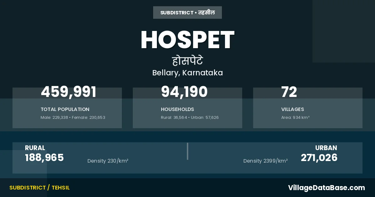
Hospet is a town and Taluka in the Bellary district of the Karnataka. In India, a Taluka is a subdivision of a district responsible for the administration and revenue collection of a specific area within the district. Talukas play a crucial role in the local governance structure, contributing significantly to the development and administration of their communities.
According to the 2011 census The total area of Hospet Taluka is 934 km², with a population of 459991 people. The population density is 492 inhabitants per square kilometre, and there are approximately 94190 houses in the sub district.
Hospet Taluka comprises about 72 villages. Below is a list of these villages along with information about their respective gram panchayats and the nearest town:
| # | Village Name | Gram Panchayat | Nearest Town |
|---|---|---|---|
| 1 | Arlihalli | Sanapura | Kampli (3 km) |
| 2 | Ayyanahalli | 114 Danapura | Hospet (20 km) |
| 3 | Basavanadurga | Chilakanahatti | Hospet |
| 4 | Belagodu | Nagenahalli | Hospet |
| 5 | Belugoduhal | No 10 Muddapura | Kampli (4 km) |
| 6 | Bukkasagara | Bukkasagara | Kamalapuram (6 km) |
| 7 | Buvvanahalli | Gadiganur | Hospet (26 km) |
| 8 | Byalakundi | Nagalapura | Hospet (25 km) |
| 9 | Byluvadigeri | Byluvaddigeri | Hospet (15 km) |
| 10 | Chikkajaiganur | Hampadevanahalli | Kampli (15 km) |
| 11 | Chilakanahatti | Chilakanahatti | Hospet (25 km) |
| 12 | Danapura | Hampi | Kamalapuram (3 km) |
| 13 | Danapuram | 114 Danapura | Hospet (10 km) |
| 14 | Danayakanakere | Dananayakanakere | Hospet (17 km) |
| 15 | Devalapura | Devalapura | Kampli (15 km) |
| 16 | Devasamudra | Devasamudra | Kampli (6 km) |
| 17 | Dharmasagara | Byluvaddigeri | Hospet (20 km) |
| 18 | Gadiganur | Gadiganur | Hospet (24 km) |
| 19 | Garga | Nagalapura | Hospet (28 km) |
| 20 | Gollarahalli | Dananayakanakere | Hospet (22 km) |
| 21 | Gonahal | Gadiganur | Kamalapuram (25 km) |
| 22 | Gudioblapura | Nagenahalli | Hospet (3 km) |
| 23 | Gundlavaddigeri | Byluvaddigeri | Hospet (16 km) |
| 24 | Hampadevanahalli | Hampadevanahalli | Kampli (15 km) |
| 25 | Hampi | Hampi | Kamalapuram (4 km) |
| 26 | Haravanahalli | Chilakanahatti | Hospet (25 km) |
| 27 | Hirejaiganur | Devasamudra | Kampli (15 km) |
| 28 | Honnahalli | Suggenahalli | Kampli (23 km) |
| 29 | Hosakota | Hospet | |
| 30 | Hosur | Hosur | Hospet (6 km) |
| 31 | Ingaligi | P K Halli | Hospet (5 km) |
| 32 | Ittigi | Sanapura | Kampli (9 km) |
| 33 | Jambunathanahalli | Hospet | |
| 34 | Jeeriganuru | Hampadevanahalli | Kampli (17 km) |
| 35 | Jowku | Hampadevanahalli | Kampli (17 km) |
| 36 | Kaddirampura | Hampi | Kamalapuram (3 km) |
| 37 | Kakubal | Byluvaddigeri | Hospet (18 km) |
| 38 | Kalghatta | Nagenahalli | Kamalapuram (3 km) |
| 39 | Kallahalli | Kallahalli | Hospet (6 km) |
| 40 | Kallirampura | Nagenahalli | Hospet (2 km) |
| 41 | Kanvithimmalapura | No 10 Muddapura | Kampli (7 km) |
| 42 | Kottiginahal | Gadiganur | Hospet (22 km) |
| 43 | Krishnapura | Hampi | Kamalapuram (3 km) |
| 44 | Malapanagudi | Malapanagudi | Kamalapuram (2 km) |
| 45 | Mariyammanahalli | Hospet (14 km) | |
| 46 | Mariyammanahalli Thanda | Hospet (15 km) | |
| 47 | Mavinahalli | Suggenahalli | Kampli (22 km) |
| 48 | Metri | Metri | Kampli (10 km) |
| 49 | Muddapura No 10 | No 10 Muddapura | Kampli (3 km) |
| 50 | Muddapura No 2 | Sanapura | Kampli (10 km) |
| 51 | Nagalapura | Nagalapura | Hospet (23 km) |
| 52 | Nagenahalli | Nagenahalli | Hospet (5 km) |
| 53 | Nandibanda | Dananayakanakere | Hospet (16 km) |
| 54 | Narasapura | Hampi | Hospet (4 km) |
| 55 | Nimbapura | Hampi | Hospet |
| 56 | Papinayakanahalli | P K Halli | Hospet (10 km) |
| 57 | Rajapura | Kallahalli | Hospet (4 km) |
| 58 | Ramasagara | Ramasagara | Kampli (6 km) |
| 59 | Sanapura | Sanapura | Kampli (4 km) |
| 60 | Sankalapuram | Suggenahalli | Hospet |
| 61 | Seetharama Tanda | Seetharama Thanda | Kamalapuram (8 km) |
| 62 | Singanathanahalli | Hampi | Kamalapuram (2 km) |
| 63 | Somalapuram | Devalapura | Kampli (18 km) |
| 64 | Sugginahalli | Suggenahalli | Kampli (20 km) |
| 65 | T Basapura | Chilakanahatti | Hospet (32 km) |
| 66 | Telugubalu | Chilakanahatti | Hospet (25 km) |
| 67 | Thimmalapura | Chilakanahatti | Hospet (32 km) |
| 68 | Upparahalli | Metri | Kampli (15 km) |
| 69 | Vadrahalli | P K Halli | Hospet (7 km) |
| 70 | Vantigodu | Chilakanahatti | Hospet |
| 71 | Venkatapura | 114 Danapura | Hospet (18 km) |
| 72 | Vyasanakeri | 114 Danapura | Hospet (15 km) |
The population is distributed between urban and rural areas as follows:
| Particulars | Rural | Urban | Total |
|---|---|---|---|
| Total Population | 188965 | 271026 | 459991 |
| Male Population | 94673 | 134665 | 229338 |
| Female Population | 94292 | 136361 | 230653 | Population Density | 230 / km² | 2399 / km² | 492 / km² |
The distribution of households in the Hospet is:
| Rural Households | Urban Households | Total Households |
|---|---|---|
| 36564 | 57626 | 94190 |
Showing 1 of 1 places
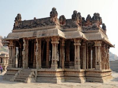
The Vittala Temple, Hampi is a prominent Temple located in Nimbapura, Bellary, Karnataka, India. The best season to visi
Q: What is Hospet?
A: Hospet is a town and in the Bellary district of the Karnataka.
Q: What is the total area of Hospet Taluka?
A: The total area of Hospet Taluka is 934 km².
Q: What is the population of Hospet Taluka according to the 2011 census?
A: According to the 2011 census, the population of Hospet Taluka is 459991.
Q: What is the population density of Hospet Taluka?
A: The population density of Hospet Taluka is 492 inhabitants per square kilometre.
Q: How many houses are there in Hospet Taluka?
A: There are approximately 94190 houses in Hospet Taluka.
Q: How many villages are there in Hospet Taluka?
A: There are about 72 villages in Hospet Taluka.
Q: Which is the largest village by population in Hospet Taluka?
A: The largest village by population in Hospet Taluka is Mariyammanahalli, with 15940 people.
Q: Which is the smallest village by population in Hospet Taluka?
A: The smallest village by population in Hospet Taluka is Basavanadurga, with 0 people.
Q: Which is the largest village by area in Hospet Taluka?
A: The largest village by area in Hospet Taluka is Seetharama Tanda, with 4915 km².
Q: Which is the smallest village by area in Hospet Taluka?
A: The smallest village by area in Hospet Taluka is Krishnapura, with 93 km².
Q: What is the male population of Hospet Taluka?
A: The male population of Hospet Taluka is 229338.
Q: What is the female population of Hospet Taluka?
A: The female population of Hospet Taluka is 230653.
Q: How many villages in Hospet Taluka have a population of less than 100?
A: There are 11 villages in Hospet Taluka with a population of less than 100.
Q: How many villages in Hospet Taluka have a population between 100 and 499?
A: There are 5 villages in Hospet Taluka with a population between 100 and 499.
Q: How many villages in Hospet Taluka have a population between 500 and 999?
A: There are 5 villages in Hospet Taluka with a population between 500 and 999.
Q: How many villages in Hospet Taluka have a population between 1000 and 1999?
A: There are 16 villages in Hospet Taluka with a population between 1000 and 1999.
Q: How many villages in Hospet Taluka have a population between 2000 and 2999?
A: There is 14 village in Hospet Taluka with a population between 2000 and 2999.
Q: How many villages in Hospet Taluka have a population between 3000 and 3999?
A: There is 6 village in Hospet Taluka with a population between 3000 and 3999.
Q: How many villages in Hospet Taluka have a population between 4000 and 4999?
A: There is 4 village in Hospet Taluka with a population between 4000 and 4999.
Q: How many villages in Hospet Taluka have a population of 5000 and above?
A: There is 11 village in Hospet Taluka with a population of 5000 and above.
| Total Population | Villages in Sub District Of Hospet |
|---|---|
| Less than 100 | 11 |
| 100-499 | 5 |
| 500-999 | 5 |
| 1000-1999 | 16 |
| 2000-2999 | 14 |
| 3000-3999 | 6 |
| 4000-4999 | 4 |
| 5000 And Above | 11 |