District → Balaghat
State → Madhya Pradesh
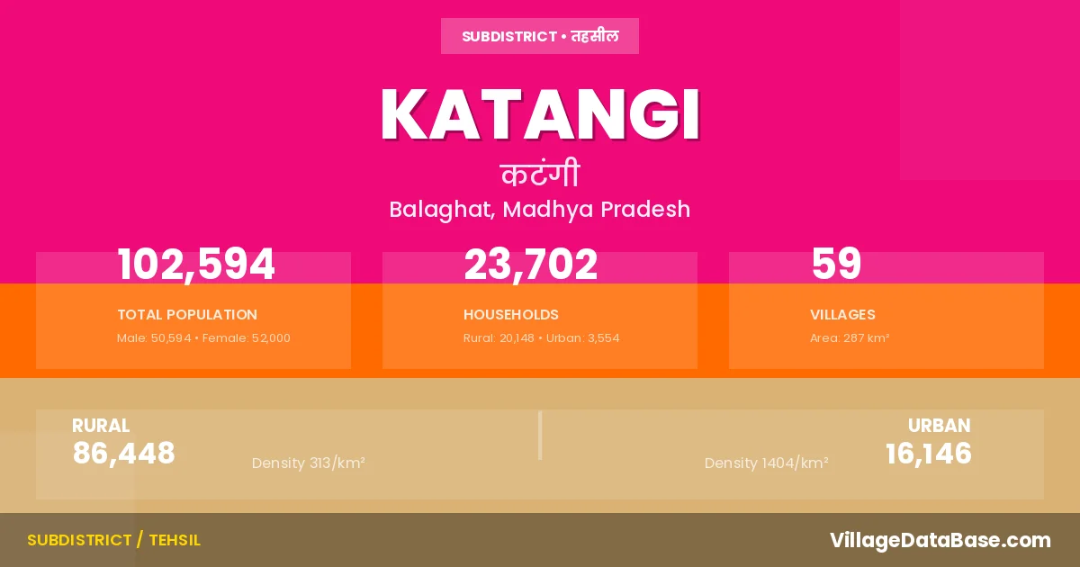
Katangi is a town and Tehsil in the Balaghat district of the Madhya Pradesh. In India, a Tehsil is a subdivision of a district responsible for the administration and revenue collection of a specific area within the district. Tehsils play a crucial role in the local governance structure, contributing significantly to the development and administration of their communities.
According to the 2011 census The total area of Katangi Tehsil is 287 km², with a population of 102594 people. The population density is 357 inhabitants per square kilometre, and there are approximately 23702 houses in the sub district.
Katangi Tehsil comprises about 59 villages. Below is a list of these villages along with information about their respective gram panchayats and the nearest town:
| # | Village Name | Gram Panchayat | Nearest Town |
|---|---|---|---|
| 1 | Agarwada | Agarwada | Katangi (8 km) |
| 2 | Agasi | Agasi | Katangi (5 km) |
| 3 | Agri | Ambejhari | Katangi (10 km) |
| 4 | Arjuni | Arjuni | Katangi (12 km) |
| 5 | Atri | Atri | Katangi (10 km) |
| 6 | Badgaon | Selwa | Katangi (6 km) |
| 7 | Bahakal | Bahkal | Katangi (10 km) |
| 8 | Banera | Banera | Katangi (8 km) |
| 9 | Barud | Barud | Katangi (12 km) |
| 10 | Basi | Basi | Katangi (10 km) |
| 11 | Bhajiyapar | Bhajiyapar | Katangi (10 km) |
| 12 | Bhajiyapar Mal | Bhajiyapar | Katangi (10 km) |
| 13 | Bisapur | Bisapur | Katangi (7 km) |
| 14 | Bopli | Katera | Katangi |
| 15 | Borikheda Mal | Kalimati | Katangi (18 km) |
| 16 | Borikheda Ryt | Kalimati | Katangi (17 km) |
| 17 | Chaukhandi | Chokhandi | Katangi (9 km) |
| 18 | Chichgaon | Sadabodi | Katangi (3 km) |
| 19 | Chikmara | Chikmara | Katangi (6 km) |
| 20 | Chirchira | Bhajiyapar | Katangi (10 km) |
| 21 | Deori | Deori | Katangi (12 km) |
| 22 | Deothana | Deothana | Katangi (9 km) |
| 23 | Dhimru Reeth | Bhajiyapar | Katangi |
| 24 | Ghunadi | Ghunadi | Katangi (10 km) |
| 25 | Gopalpur | Ujadbopali | Katangi (4 km) |
| 26 | Jam | Jam | Katangi (10 km) |
| 27 | Jamuniya | Jamuniya | Katangi (10 km) |
| 28 | Jarah Mohgaon | Jarahmohgaon | Katangi (14 km) |
| 29 | Kachhar F V | Bhajiyapar | Katangi |
| 30 | Kalgaon | Kalgaon | Katangi (10 km) |
| 31 | Kalimati | Kalimati | Katangi (16 km) |
| 32 | Kamthi | Kamthi | Katangi (8 km) |
| 33 | Katarkana | Tekadi M | Katangi (4 km) |
| 34 | Katera | Katera | Katangi |
| 35 | Khairlangi | Khairlanji | Katangi (7 km) |
| 36 | Khajri | Khajri | Katangi (3 km) |
| 37 | Khamariya | Khamariya | Katangi (4 km) |
| 38 | Kodmi | Kodmi | Katangi (5 km) |
| 39 | Kosmi | Kosmi | Katangi (6 km) |
| 40 | Lakhanwada | Lakhanwada | Katangi (8 km) |
| 41 | Linga Paunar | Lingapaunar | Katangi (18 km) |
| 42 | Lohagri Ryt | Agri | Katangi (12 km) |
| 43 | Lohamara | Lohmara | Katangi (5 km) |
| 44 | Maheduli | Maheduli | Katangi (9 km) |
| 45 | Manegaon | Manegaon | Katangi (6 km) |
| 46 | Nahlesara | Basi | Katangi (6 km) |
| 47 | Nandleasra | Nandlesara | Katangi (7 km) |
| 48 | Nandora | Nandora | Katangi (13 km) |
| 49 | Patharwada | Patharwada | Katangi (4 km) |
| 50 | Samatpuri | Samatpuri | Katangi (10 km) |
| 51 | Sawngi | Sawangi | Katangi (6 km) |
| 52 | Selwa | Selwa | Katangi (5 km) |
| 53 | Singodi | Singodi | Katangi (5 km) |
| 54 | Sirpur | Sirpur | Katangi (10 km) |
| 55 | Sitakhoh | Sitakhoh | Katangi (9 km) |
| 56 | Takadi | Tekadi Bh | Katangi (12 km) |
| 57 | Tekadi | Tekadi Ka | Katangi (5 km) |
| 58 | Ujad Bopli | Ujadbopali | Katangi (3 km) |
| 59 | Umri | Umri | Katangi (3 km) |
The population is distributed between urban and rural areas as follows:
| Particulars | Rural | Urban | Total |
|---|---|---|---|
| Total Population | 86448 | 16146 | 102594 |
| Male Population | 42465 | 8129 | 50594 |
| Female Population | 43983 | 8017 | 52000 | Population Density | 313 / km² | 1404 / km² | 357 / km² |
The distribution of households in the Katangi is:
| Rural Households | Urban Households | Total Households |
|---|---|---|
| 20148 | 3554 | 23702 |
Q: What is Katangi?
A: Katangi is a town and in the Balaghat district of the Madhya Pradesh.
Q: What is the total area of Katangi Tehsil?
A: The total area of Katangi Tehsil is 287 km².
Q: What is the population of Katangi Tehsil according to the 2011 census?
A: According to the 2011 census, the population of Katangi Tehsil is 102594.
Q: What is the population density of Katangi Tehsil?
A: The population density of Katangi Tehsil is 357 inhabitants per square kilometre.
Q: How many houses are there in Katangi Tehsil?
A: There are approximately 23702 houses in Katangi Tehsil.
Q: How many villages are there in Katangi Tehsil?
A: There are about 59 villages in Katangi Tehsil.
Q: Which is the largest village by population in Katangi Tehsil?
A: The largest village by population in Katangi Tehsil is Jarah Mohgaon, with 3728 people.
Q: Which is the smallest village by population in Katangi Tehsil?
A: The smallest village by population in Katangi Tehsil is Kachhar F V, with 147 people.
Q: Which is the largest village by area in Katangi Tehsil?
A: The largest village by area in Katangi Tehsil is Jarah Mohgaon, with 1013 km².
Q: Which is the smallest village by area in Katangi Tehsil?
A: The smallest village by area in Katangi Tehsil is Lohagri Ryt, with 100 km².
Q: What is the male population of Katangi Tehsil?
A: The male population of Katangi Tehsil is 50594.
Q: What is the female population of Katangi Tehsil?
A: The female population of Katangi Tehsil is 52000.
Q: How many villages in Katangi Tehsil have a population between 100 and 499?
A: There are 5 villages in Katangi Tehsil with a population between 100 and 499.
Q: How many villages in Katangi Tehsil have a population between 500 and 999?
A: There are 11 villages in Katangi Tehsil with a population between 500 and 999.
Q: How many villages in Katangi Tehsil have a population between 1000 and 1999?
A: There are 32 villages in Katangi Tehsil with a population between 1000 and 1999.
Q: How many villages in Katangi Tehsil have a population between 2000 and 2999?
A: There is 10 village in Katangi Tehsil with a population between 2000 and 2999.
Q: How many villages in Katangi Tehsil have a population between 3000 and 3999?
A: There is 1 village in Katangi Tehsil with a population between 3000 and 3999.
| Total Population | Villages in Sub District Of Katangi |
|---|---|
| 100-499 | 5 |
| 500-999 | 11 |
| 1000-1999 | 32 |
| 2000-2999 | 10 |
| 3000-3999 | 1 |