District → Barwani
State → Madhya Pradesh
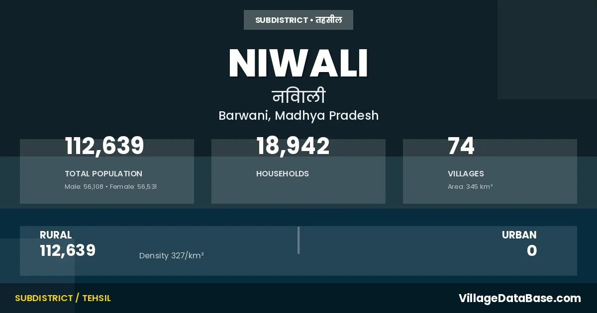
Niwali is a town and Tehsil in the Barwani district of the Madhya Pradesh. In India, a Tehsil is a subdivision of a district responsible for the administration and revenue collection of a specific area within the district. Tehsils play a crucial role in the local governance structure, contributing significantly to the development and administration of their communities.
According to the 2011 census The total area of Niwali Tehsil is 345 km², with a population of 112639 people. The population density is 327 inhabitants per square kilometre, and there are approximately 18942 houses in the sub district.
Niwali Tehsil comprises about 74 villages. Below is a list of these villages along with information about their respective gram panchayats and the nearest town:
| # | Village Name | Gram Panchayat | Nearest Town |
|---|---|---|---|
| 1 | Badgaon | Badgaon | Sendhwa (30 km) |
| 2 | Badgaon Urf Bhangeedad | Morgun | Sendhwa (16 km) |
| 3 | Bhensdad | Bhaisdad | Sendhwa |
| 4 | Bhoolgaon | Bhulgaon | Sendhwa (17 km) |
| 5 | Bhoorapani | Bhurapani | Sendhwa (12 km) |
| 6 | Borli | Borali | Sendhwa (8 km) |
| 7 | Budhgaon | Mogarikheda | Sendhwa (15 km) |
| 8 | Chatli | Chatli | Sendhwa (7 km) |
| 9 | Chichaba | Rajmalivan | Sendhwa (16 km) |
| 10 | Dhanbawardi | Jamnya | Sendhwa (24 km) |
| 11 | Diwaniya | Diwani | Sendhwa (10 km) |
| 12 | Dogaliyapani | Donglyapani | Sendhwa |
| 13 | Dondwada | Dondwada | Sendhwa (13 km) |
| 14 | Dongalyapani | Donglyapani | Sendhwa (23 km) |
| 15 | Gawadi | Gawadi | Sendhwa (8 km) |
| 16 | Gawali | Sendhwa (23 km) | |
| 17 | Gawalivan | Donglyapani | Sendhwa (20 km) |
| 18 | Ghodlya Pani | Ghodlyapani | Sendhwa (31 km) |
| 19 | Ghodlyapani | Ghodlyapani | Sendhwa |
| 20 | Gondikachali | Sendhwa (24 km) | |
| 21 | Guljwari | Fooljuwari | Sendhwa |
| 22 | Gumadya Buzurg | Gumadiya Bujurg | Sendhwa |
| 23 | Gumadya Khurd | Gumadiya Khurd | Sendhwa (24 km) |
| 24 | Gumdiya | Gumadiya Bujurg | Sendhwa (24 km) |
| 25 | Jamaniya | Jamnya | Sendhwa (26 km) |
| 26 | Jamanya | Jamnya Ab Road | Sendhwa (10 km) |
| 27 | Jhakar | Mansur | Sendhwa |
| 28 | Jharimal | Sendhwa (26 km) | |
| 29 | Jharimata | Zarimata | Sendhwa (20 km) |
| 30 | Jod Mohra | Bhaisdad | Sendhwa (14 km) |
| 31 | Jogwada | Jogwada | Sendhwa (10 km) |
| 32 | Kannadgaon | Kannadgaon | Sendhwa (16 km) |
| 33 | Kanpuri | Kanpuri | Sendhwa (18 km) |
| 34 | Khadakivan | Khadkivan | Sendhwa (25 km) |
| 35 | Khadki | Khadkivan | Sendhwa (30 km) |
| 36 | Khadkiya | Sakad | Sendhwa (16 km) |
| 37 | Khampani | Donglyapani | Sendhwa (18 km) |
| 38 | Khedi | Khedi | Sendhwa (12 km) |
| 39 | Kukdiya | Jogwada | Sendhwa |
| 40 | Kunjari | Kunjri | Sendhwa (10 km) |
| 41 | Kusmya | Kusmya | Sendhwa |
| 42 | Madsingya | Jamnya Ab Road | Sendhwa (15 km) |
| 43 | Mahulya | Purushkheda | Sendhwa (18 km) |
| 44 | Mansur | Mansur | Sendhwa (23 km) |
| 45 | Merkhedi | Sildad | Sendhwa (3 km) |
| 46 | Mogarikheda | Mogarikheda | Sendhwa (16 km) |
| 47 | Morgun | Morgun | Sendhwa (13 km) |
| 48 | Mujala | Bhulgaon | Sendhwa (14 km) |
| 49 | Nani Jhari | Gumadiya Khurd | Sendhwa (27 km) |
| 50 | Nani Niwali | Sendhwa (18 km) | |
| 51 | Nanijhari | Sendhwa (24 km) | |
| 52 | Niliyarbawardi | Sendhwa (26 km) | |
| 53 | Niwali Buzurg | Niwali Bujurg | Sendhwa (18 km) |
| 54 | Niwalikhurd | Niwali Khurd | Sendhwa |
| 55 | Pichhodi | Kusmya | Sendhwa (18 km) |
| 56 | Pipaldhar | Pipaldhar | Sendhwa (3 km) |
| 57 | Prushkheda | Purushkheda | Sendhwa (16 km) |
| 58 | Rai | Rai | Sendhwa (15 km) |
| 59 | Rajmali | Zarimata | Sendhwa (19 km) |
| 60 | Rajmalivan | Rajmalivan | Sendhwa (18 km) |
| 61 | Sakad | Sakad | Sendhwa (9 km) |
| 62 | Salun | Salun | Sendhwa (23 km) |
| 63 | Segawi | Sengvi | Sendhwa (10 km) |
| 64 | Sekatmuhali | Borali | Sendhwa (7 km) |
| 65 | Sidadi | Sidadi | Sendhwa (25 km) |
| 66 | Sidardi | Sendhwa (25 km) | |
| 67 | Sildad | Sildad | Sendhwa (3 km) |
| 68 | Sulgaon | Sulgaon | Sendhwa (24 km) |
| 69 | Talab | Talaw | Sendhwa (23 km) |
| 70 | Talav | Talaw | Sendhwa (26 km) |
| 71 | Umariyapani | Rai | Sendhwa (15 km) |
| 72 | Wajhar | Vajhar | Sendhwa (30 km) |
| 73 | Warlyapani | Kanpuri | Sendhwa (18 km) |
| 74 | Wasawi | Vasvi | Sendhwa (4 km) |
The population is distributed between urban and rural areas as follows:
| Particulars | Rural | Urban | Total |
|---|---|---|---|
| Total Population | 112639 | 0 | 112639 |
| Male Population | 56108 | 0 | 56108 |
| Female Population | 56531 | 0 | 56531 | Population Density | 327 / km² | 327 / km² |
The distribution of households in the Niwali is:
| Rural Households | Urban Households | Total Households |
|---|---|---|
| 18942 | 0 | 18942 |
Q: What is Niwali?
A: Niwali is a town and in the Barwani district of the Madhya Pradesh.
Q: What is the total area of Niwali Tehsil?
A: The total area of Niwali Tehsil is 345 km².
Q: What is the population of Niwali Tehsil according to the 2011 census?
A: According to the 2011 census, the population of Niwali Tehsil is 112639.
Q: What is the population density of Niwali Tehsil?
A: The population density of Niwali Tehsil is 327 inhabitants per square kilometre.
Q: How many houses are there in Niwali Tehsil?
A: There are approximately 18942 houses in Niwali Tehsil.
Q: How many villages are there in Niwali Tehsil?
A: There are about 74 villages in Niwali Tehsil.
Q: Which is the largest village by population in Niwali Tehsil?
A: The largest village by population in Niwali Tehsil is Niwali Buzurg, with 11760 people.
Q: Which is the smallest village by population in Niwali Tehsil?
A: The smallest village by population in Niwali Tehsil is Dogaliyapani, with 0 people.
Q: Which is the largest village by area in Niwali Tehsil?
A: The largest village by area in Niwali Tehsil is Guljwari, with 2177 km².
Q: Which is the smallest village by area in Niwali Tehsil?
A: The smallest village by area in Niwali Tehsil is Dogaliyapani, with 0 km².
Q: What is the population distribution between urban and rural areas in Niwali Tehsil?
A: The population distribution in Niwali Tehsil is entirely rural, with a total rural population of 112639.
Q: What is the male population of Niwali Tehsil?
A: The male population of Niwali Tehsil is 56108.
Q: What is the female population of Niwali Tehsil?
A: The female population of Niwali Tehsil is 56531.
Q: How is the household distribution in Niwali Tehsil?
A: The household distribution in Niwali Tehsil is entirely rural, with a total of 18942 households.
Q: How many villages in Niwali Tehsil have a population of less than 100?
A: There are 8 villages in Niwali Tehsil with a population of less than 100.
Q: How many villages in Niwali Tehsil have a population between 100 and 499?
A: There are 6 villages in Niwali Tehsil with a population between 100 and 499.
Q: How many villages in Niwali Tehsil have a population between 500 and 999?
A: There are 16 villages in Niwali Tehsil with a population between 500 and 999.
Q: How many villages in Niwali Tehsil have a population between 1000 and 1999?
A: There are 28 villages in Niwali Tehsil with a population between 1000 and 1999.
Q: How many villages in Niwali Tehsil have a population between 2000 and 2999?
A: There is 7 village in Niwali Tehsil with a population between 2000 and 2999.
Q: How many villages in Niwali Tehsil have a population between 3000 and 3999?
A: There is 7 village in Niwali Tehsil with a population between 3000 and 3999.
Q: How many villages in Niwali Tehsil have a population between 4000 and 4999?
A: There is 1 village in Niwali Tehsil with a population between 4000 and 4999.
Q: How many villages in Niwali Tehsil have a population of 5000 and above?
A: There is 1 village in Niwali Tehsil with a population of 5000 and above.
| Total Population | Villages in Sub District Of Niwali |
|---|---|
| Less than 100 | 8 |
| 100-499 | 6 |
| 500-999 | 16 |
| 1000-1999 | 28 |
| 2000-2999 | 7 |
| 3000-3999 | 7 |
| 4000-4999 | 1 |
| 5000 And Above | 1 |