District → Chhatarpur
State → Madhya Pradesh
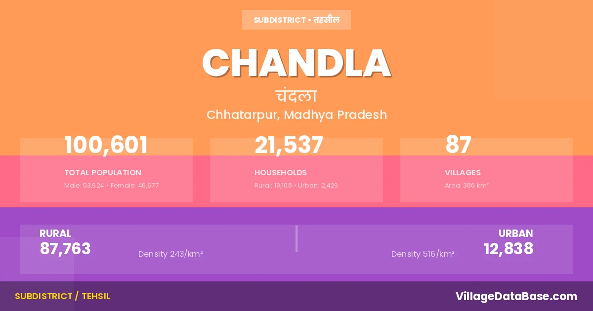
Chandla is a town and Tehsil in the Chhatarpur district of the Madhya Pradesh. In India, a Tehsil is a subdivision of a district responsible for the administration and revenue collection of a specific area within the district. Tehsils play a crucial role in the local governance structure, contributing significantly to the development and administration of their communities.
According to the 2011 census The total area of Chandla Tehsil is 386 km², with a population of 100601 people. The population density is 260 inhabitants per square kilometre, and there are approximately 21537 houses in the sub district.
Chandla Tehsil comprises about 87 villages. Below is a list of these villages along with information about their respective gram panchayats and the nearest town:
| # | Village Name | Gram Panchayat | Nearest Town |
|---|---|---|---|
| 1 | Amaha | Bansiya | Chandla (9 km) |
| 2 | Andhiyari Bari | Andhiyaribari | Chandla (16 km) |
| 3 | Bachhon | Bachhaun | Chandla (16 km) |
| 4 | Badhari | Harrai | Chandla (13 km) |
| 5 | Bairagiya Pukhari | Bairagiya Pukhari | Chandla (6 km) |
| 6 | Balkaura | Balkaura | Chandla (10 km) |
| 7 | Banjari | Banjari | Chandla (8 km) |
| 8 | Bansiya | Bansiya | Chandla (10 km) |
| 9 | Basahara | Simariya | Chandla (7 km) |
| 10 | Basantpur | Basantpur | Chandla |
| 11 | Bedee | Bedi | Laundi (16 km) |
| 12 | Beehar Purwa | Bhagaura | Chandla (10 km) |
| 13 | Bhagaura | Bhagaura | Chandla (8 km) |
| 14 | Bhaira | Bhaira | Chandla (22 km) |
| 15 | Bhairahi | Hatohan | Chandla (15 km) |
| 16 | Bhawanipur | Bhumanipur | Laundi (22 km) |
| 17 | Bigpur | Bigpur | Chandla (25 km) |
| 18 | Bilhari | Bilhari | Chandla (22 km) |
| 19 | Binamak Har | Ramjhala | Chandla (5 km) |
| 20 | Bishankhera | Bairagiya Pukhari | Chandla (4 km) |
| 21 | Byas Badaura | Vyas Badaura | Chandla (10 km) |
| 22 | Chak Hathoha | Hatohan | Chandla (8 km) |
| 23 | Chhapra | Madhaupur | Chandla (9 km) |
| 24 | Chhatarpur | Chhat Pura | Chandla (8 km) |
| 25 | Chhati Bamhori | Chhati Bamhauri | Chandla (8 km) |
| 26 | Dadiya | Ranipura | Chandla (13 km) |
| 27 | Deori | Devari | Laundi (20 km) |
| 28 | Dharampura | Bhumanipur | Chandla (22 km) |
| 29 | Dumkhera | Raopur | Chandla (5 km) |
| 30 | Gaharawan | Chhat Pura | Chandla (9 km) |
| 31 | Ganpat Kheda | Ganpat Khoda | Chandla (13 km) |
| 32 | Ghoora Purwa | Ghoora Purwa | Chandla (10 km) |
| 33 | Gudhaura | Gudhaura | Chandla (26 km) |
| 34 | Gumanpur | Hinauta | Chandla (9 km) |
| 35 | Harraee | Harrai | Chandla (12 km) |
| 36 | Hathoha | Hatohan | Chandla (8 km) |
| 37 | Hidorabari | Basantpur | Chandla (8 km) |
| 38 | Himmatpur | Simariya | Chandla (6 km) |
| 39 | Hinota | Ragauli | Chandla (10 km) |
| 40 | Jagatpur | Ranipura | Chandla (14 km) |
| 41 | Jarawara | Bairagiya Pukhari | Chandla (9 km) |
| 42 | Kamalpurwa | Bairagiya Pukhari | Chandla (5 km) |
| 43 | Kanbhaee | Ghoora Purwa | Chandla (10 km) |
| 44 | Katiya | Katiya | Laundi (21 km) |
| 45 | Khairahi | Sadkar | Chandla (8 km) |
| 46 | Kharaba | Hatohan | Chandla (5 km) |
| 47 | Khodha | Patna | Chandla (15 km) |
| 48 | Khurd Gudha | Ramjhala | Chandla (5 km) |
| 49 | Kitpura | Ranipura | Chandla (19 km) |
| 50 | Lasgarha | Hatohan | Chandla (10 km) |
| 51 | Lawraha | Labraha | Chandla (7 km) |
| 52 | Ludhgayan | Ludgay | Chandla (7 km) |
| 53 | Luhar Purwa | Bairagiya Pukhari | Chandla (3 km) |
| 54 | Madhaupur | Madhaupur | Chandla (7 km) |
| 55 | Makundpur | Ranipura | Chandla (19 km) |
| 56 | Nagrauli | Gudhaura | Chandla (15 km) |
| 57 | Pacham Nagar | Pamcham Nagar | Chandla (22 km) |
| 58 | Padari | Vyas Badaura | Chandla (6 km) |
| 59 | Panchampur | Rajapur | Chandla (20 km) |
| 60 | Pandepurwa | Pande Pur | Chandla (9 km) |
| 61 | Parmajhor | Devari | Laundi (23 km) |
| 62 | Parsaniya | Parsaniya | Chandla (30 km) |
| 63 | Parsendi | Ludgay | Chandla (6 km) |
| 64 | Patalee | Simariya | Chandla (4 km) |
| 65 | Patna | Patna | Chandla (14 km) |
| 66 | Pawai | Banjari | Chandla (6 km) |
| 67 | Pukhraha | Hatohan | Chandla (6 km) |
| 68 | Rajapur | Rajapur | Laundi (25 km) |
| 69 | Rajpurwa | Andhiyaribari | Chandla (10 km) |
| 70 | Ramjhala | Ramjhala | Chandla (5 km) |
| 71 | Ranipur | Ranipura | Chandla (11 km) |
| 72 | Raopur | Raopur | Chandla (8 km) |
| 73 | Ratanpur | Ghoora Purwa | Chandla (10 km) |
| 74 | Sadkar | Sadkar | Chandla (14 km) |
| 75 | Salaiya | Katiya | Laundi (23 km) |
| 76 | Sarai | Labraha | Chandla (10 km) |
| 77 | Shahpur | Bedi | Laundi (22 km) |
| 78 | Silgaon | Chhati Bamhauri | Chandla (5 km) |
| 79 | Silpatpura | Bhaira | Chandla (33 km) |
| 80 | Simariya | Simariya | Chandla (7 km) |
| 81 | Simrahi | Suraj Pura | Laundi (26 km) |
| 82 | Sirha | Patna | Chandla |
| 83 | Surajpur | Suraj Pura | Laundi (28 km) |
| 84 | Tahanga Charai Purwa | Tahenga | Chandla (13 km) |
| 85 | Tikari | Ganpat Khoda | Chandla (10 km) |
| 86 | Tiktai | Rajapur | Laundi (25 km) |
| 87 | Umarahar | Madhaupur | Chandla (5 km) |
The population is distributed between urban and rural areas as follows:
| Particulars | Rural | Urban | Total |
|---|---|---|---|
| Total Population | 87763 | 12838 | 100601 |
| Male Population | 47206 | 6718 | 53924 |
| Female Population | 40557 | 6120 | 46677 | Population Density | 243 / km² | 516 / km² | 260 / km² |
The distribution of households in the Chandla is:
| Rural Households | Urban Households | Total Households |
|---|---|---|
| 19108 | 2429 | 21537 |
Q: What is Chandla?
A: Chandla is a town and in the Chhatarpur district of the Madhya Pradesh.
Q: What is the total area of Chandla Tehsil?
A: The total area of Chandla Tehsil is 386 km².
Q: What is the population of Chandla Tehsil according to the 2011 census?
A: According to the 2011 census, the population of Chandla Tehsil is 100601.
Q: What is the population density of Chandla Tehsil?
A: The population density of Chandla Tehsil is 260 inhabitants per square kilometre.
Q: How many houses are there in Chandla Tehsil?
A: There are approximately 21537 houses in Chandla Tehsil.
Q: How many villages are there in Chandla Tehsil?
A: There are about 87 villages in Chandla Tehsil.
Q: Which is the largest village by population in Chandla Tehsil?
A: The largest village by population in Chandla Tehsil is Bachhon, with 6718 people.
Q: Which is the smallest village by population in Chandla Tehsil?
A: The smallest village by population in Chandla Tehsil is Chak Hathoha, with 0 people.
Q: Which is the largest village by area in Chandla Tehsil?
A: The largest village by area in Chandla Tehsil is Bachhon, with 3344 km².
Q: Which is the smallest village by area in Chandla Tehsil?
A: The smallest village by area in Chandla Tehsil is Chak Hathoha, with 15 km².
Q: What is the male population of Chandla Tehsil?
A: The male population of Chandla Tehsil is 53924.
Q: What is the female population of Chandla Tehsil?
A: The female population of Chandla Tehsil is 46677.
Q: How many villages in Chandla Tehsil have a population of less than 100?
A: There are 1 villages in Chandla Tehsil with a population of less than 100.
Q: How many villages in Chandla Tehsil have a population between 100 and 499?
A: There are 23 villages in Chandla Tehsil with a population between 100 and 499.
Q: How many villages in Chandla Tehsil have a population between 500 and 999?
A: There are 24 villages in Chandla Tehsil with a population between 500 and 999.
Q: How many villages in Chandla Tehsil have a population between 1000 and 1999?
A: There are 33 villages in Chandla Tehsil with a population between 1000 and 1999.
Q: How many villages in Chandla Tehsil have a population between 2000 and 2999?
A: There is 3 village in Chandla Tehsil with a population between 2000 and 2999.
Q: How many villages in Chandla Tehsil have a population between 3000 and 3999?
A: There is 2 village in Chandla Tehsil with a population between 3000 and 3999.
Q: How many villages in Chandla Tehsil have a population of 5000 and above?
A: There is 1 village in Chandla Tehsil with a population of 5000 and above.
| Total Population | Villages in Sub District Of Chandla |
|---|---|
| Less than 100 | 1 |
| 100-499 | 23 |
| 500-999 | 24 |
| 1000-1999 | 33 |
| 2000-2999 | 3 |
| 3000-3999 | 2 |
| 5000 And Above | 1 |