District → Chhatarpur
State → Madhya Pradesh
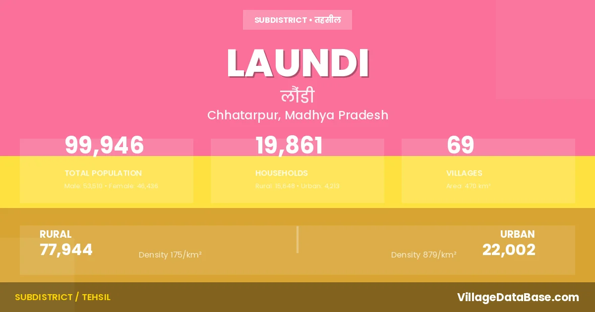
Laundi is a town and Tehsil in the Chhatarpur district of the Madhya Pradesh. In India, a Tehsil is a subdivision of a district responsible for the administration and revenue collection of a specific area within the district. Tehsils play a crucial role in the local governance structure, contributing significantly to the development and administration of their communities.
According to the 2011 census The total area of Laundi Tehsil is 470 km², with a population of 99946 people. The population density is 213 inhabitants per square kilometre, and there are approximately 19861 houses in the sub district.
Laundi Tehsil comprises about 69 villages. Below is a list of these villages along with information about their respective gram panchayats and the nearest town:
| # | Village Name | Gram Panchayat | Nearest Town |
|---|---|---|---|
| 1 | Aktoha | Aktoha | Laundi (5 km) |
| 2 | Bagmau | Bagmau | Laundi (7 km) |
| 3 | Bajaura | Pratappura | Laundi (10 km) |
| 4 | Bamhori | Bamhori | Laundi (16 km) |
| 5 | Bamhori Purwa | Bamhori Purwa | Laundi (12 km) |
| 6 | Bando | Bamhori | Laundi (10 km) |
| 7 | Barhakheda | Muderi | Laundi (9 km) |
| 8 | Barohan | Ragauli | Laundi |
| 9 | Bhadar | Bhadar | Laundi (20 km) |
| 10 | Bhitariya | Doni | Laundi (18 km) |
| 11 | Biduanpurwa | Purwa Bamhori | Laundi (14 km) |
| 12 | Bihta | Sijai | Laundi (12 km) |
| 13 | Bitalipurwa | Jyoraha | Laundi (10 km) |
| 14 | Chithari | Chitahari | Laundi (10 km) |
| 15 | Dadhmau | Ragauli | Laundi (15 km) |
| 16 | Deonagar | Deo Nagar | Laundi (7 km) |
| 17 | Deopura | Devpur | Laundi (3 km) |
| 18 | Devi Kheda | Bagmau | Laundi (9 km) |
| 19 | Dhudha Alias Laxmanpura | Bamhori | Laundi (10 km) |
| 20 | Didwara | Didwara | Mahoba (5 km) |
| 21 | Doni | Doni | Laundi (20 km) |
| 22 | Giloha | Gilaunha | Laundi (15 km) |
| 23 | Girdhauri | Khapatya | Laundi (7 km) |
| 24 | Gudha Khurd | Madha | Laundi (3 km) |
| 25 | Gurha Kalan | Gudha Kala | Laundi (3 km) |
| 26 | Haduwa | Pratappura | Laundi (8 km) |
| 27 | Hansari | Bamhori | Laundi (10 km) |
| 28 | Hanspura | Tahenga | Laundi (13 km) |
| 29 | Hardwar | Hardwar | Laundi (3 km) |
| 30 | Hinota | Hinauta | Laundi |
| 31 | Itwan | Pura | Laundi (13 km) |
| 32 | Jamupura | Sijai | Laundi (12 km) |
| 33 | Jhinna | Patha | Laundi (25 km) |
| 34 | Jyoraha | Jyoraha | Laundi (9 km) |
| 35 | Kathara | Katehara | Laundi (11 km) |
| 36 | Kesharipura | Katehara | Laundi (13 km) |
| 37 | Khapataya | Khapatya | Laundi (8 km) |
| 38 | Madanpura | Sijai | Laundi (12 km) |
| 39 | Madha | Madha | Laundi (4 km) |
| 40 | Madwa | Katehara | Laundi (13 km) |
| 41 | Midka | Midka | Laundi (15 km) |
| 42 | Muderi Dakshini | Muderi | Laundi (9 km) |
| 43 | Muderi Uttari | Muderi | Laundi (9 km) |
| 44 | Mudwara | Deo Nagar | Laundi (7 km) |
| 45 | Pahara | Doni | Laundi (18 km) |
| 46 | Partappura | Pratappura | Laundi (5 km) |
| 47 | Patha | Patha | Laundi (25 km) |
| 48 | Patti | Tahenga | Laundi (13 km) |
| 49 | Peera | Peera | Laundi (8 km) |
| 50 | Pipari | Midka | Laundi |
| 51 | Pura | Pura | Laundi (17 km) |
| 52 | Purwa Bamohri | Purwa Bamhori | Laundi (12 km) |
| 53 | Ragouli | Ragauli | Laundi (16 km) |
| 54 | Rampur | Ragauli | Laundi (20 km) |
| 55 | Ramupura | Bhadar | Laundi (22 km) |
| 56 | Ranipura | Khapatya | Laundi (4 km) |
| 57 | Ranmau | Madha | Laundi (7 km) |
| 58 | Ratanpara | Katehara | Laundi (11 km) |
| 59 | Rekha | Peera | Laundi (8 km) |
| 60 | Sadafal | Tahenga | Laundi (8 km) |
| 61 | Sahapura | Muderi | Laundi |
| 62 | Shahpura | Gilaunha | Laundi (18 km) |
| 63 | Siddhupur | Purwa Bamhori | Laundi (14 km) |
| 64 | Sijaee | Sijai | Laundi (11 km) |
| 65 | Sumedi | Peera | Laundi (15 km) |
| 66 | Surekhi | Bamhori | Laundi (5 km) |
| 67 | Tahanga | Balkaura | Laundi (13 km) |
| 68 | Thurati | Deo Nagar | Laundi (6 km) |
| 69 | Tikaura | Muderi | Laundi (10 km) |
The population is distributed between urban and rural areas as follows:
| Particulars | Rural | Urban | Total |
|---|---|---|---|
| Total Population | 77944 | 22002 | 99946 |
| Male Population | 41770 | 11740 | 53510 |
| Female Population | 36174 | 10262 | 46436 | Population Density | 175 / km² | 879 / km² | 213 / km² |
The distribution of households in the Laundi is:
| Rural Households | Urban Households | Total Households |
|---|---|---|
| 15648 | 4213 | 19861 |
Q: What is Laundi?
A: Laundi is a town and in the Chhatarpur district of the Madhya Pradesh.
Q: What is the total area of Laundi Tehsil?
A: The total area of Laundi Tehsil is 470 km².
Q: What is the population of Laundi Tehsil according to the 2011 census?
A: According to the 2011 census, the population of Laundi Tehsil is 99946.
Q: What is the population density of Laundi Tehsil?
A: The population density of Laundi Tehsil is 213 inhabitants per square kilometre.
Q: How many houses are there in Laundi Tehsil?
A: There are approximately 19861 houses in Laundi Tehsil.
Q: How many villages are there in Laundi Tehsil?
A: There are about 69 villages in Laundi Tehsil.
Q: Which is the largest village by population in Laundi Tehsil?
A: The largest village by population in Laundi Tehsil is Jyoraha, with 4340 people.
Q: Which is the smallest village by population in Laundi Tehsil?
A: The smallest village by population in Laundi Tehsil is Barhakheda, with 0 people.
Q: Which is the largest village by area in Laundi Tehsil?
A: The largest village by area in Laundi Tehsil is Jyoraha, with 2045 km².
Q: Which is the smallest village by area in Laundi Tehsil?
A: The smallest village by area in Laundi Tehsil is Barhakheda, with 44 km².
Q: What is the male population of Laundi Tehsil?
A: The male population of Laundi Tehsil is 53510.
Q: What is the female population of Laundi Tehsil?
A: The female population of Laundi Tehsil is 46436.
Q: How many villages in Laundi Tehsil have a population of less than 100?
A: There are 9 villages in Laundi Tehsil with a population of less than 100.
Q: How many villages in Laundi Tehsil have a population between 100 and 499?
A: There are 14 villages in Laundi Tehsil with a population between 100 and 499.
Q: How many villages in Laundi Tehsil have a population between 500 and 999?
A: There are 16 villages in Laundi Tehsil with a population between 500 and 999.
Q: How many villages in Laundi Tehsil have a population between 1000 and 1999?
A: There are 18 villages in Laundi Tehsil with a population between 1000 and 1999.
Q: How many villages in Laundi Tehsil have a population between 2000 and 2999?
A: There is 7 village in Laundi Tehsil with a population between 2000 and 2999.
Q: How many villages in Laundi Tehsil have a population between 3000 and 3999?
A: There is 4 village in Laundi Tehsil with a population between 3000 and 3999.
Q: How many villages in Laundi Tehsil have a population between 4000 and 4999?
A: There is 1 village in Laundi Tehsil with a population between 4000 and 4999.
| Total Population | Villages in Sub District Of Laundi |
|---|---|
| Less than 100 | 9 |
| 100-499 | 14 |
| 500-999 | 16 |
| 1000-1999 | 18 |
| 2000-2999 | 7 |
| 3000-3999 | 4 |
| 4000-4999 | 1 |