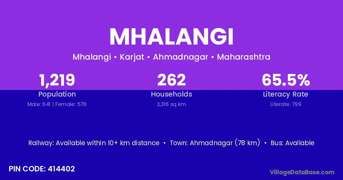
Mhalangi village is located in the Karjat Tehsil of the Ahmadnagar district in Maharashtra .
Block / Tehsil → Karjat
District → Ahmadnagar
State → Maharashtra
According to Census 2011 information, the village code of Mhalangi village is 414402.
Mhalangi village has a total population of 1,219 people, of which 641 are males and 578 are females.
The literacy rate of Mhalangi village is 65.55%. Male literacy stands at 71.14% and female literacy at 59.34%.
There are approximately 262 households in Mhalangi village.
Ahmadnagar (78 km) is the nearest town to Mhalangi village for major economic activities and is located approximately 78 km away.
The population of Mhalangi village is distributed between literate and illiterate residents as follows:
| Particulars | Male | Female | Total |
|---|---|---|---|
| Literate | 456 | 343 | 799 |
| Illiterate | 185 | 235 | 420 |
| Total | 641 | 578 | 1,219 |
Source: Census 2011
| Village | District |
|---|---|
| Alsunde | Ahmadnagar |
| Alsunde | Raigarh |
| Alsunde | Solapur |
| Ambijalgaon | Ahmadnagar |
| Dhalwadi | Ahmadnagar |
| Dombalwadi | Ahmadnagar |
| Dombalwadi | Satara |
| Dombalwadi | Solapur |
| Kuldharan | Ahmadnagar |
| Kumbhefal | Ahmadnagar |
| Kumbhefal | Ahmadnagar |
| Kumbhefal | Buldana |
| Nimbe | Ahmadnagar |
| Nimbe | Ahmadnagar |
| Rakshaswadi Bk | Ahmadnagar |
| Rakshaswadi Kh | Ahmadnagar |
| Shegud | Ahmadnagar |
| Supekarwadi | Ahmadnagar |
No reviews yet. Be the first to review this village!
Available within 10+ km distance
Available within village
Available within 10+ km distance