District → Gadchiroli
State → Maharashtra
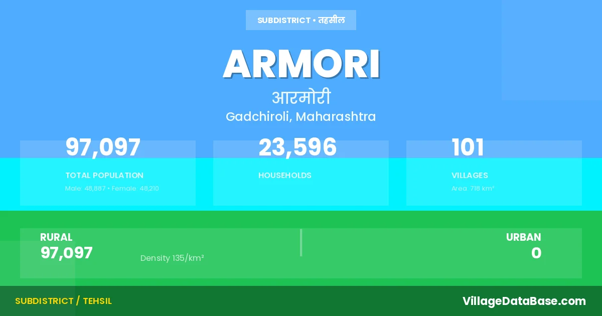
Armori is a town and Tehsil in the Gadchiroli district of the Maharashtra. In India, a Tehsil is a subdivision of a district responsible for the administration and revenue collection of a specific area within the district. Tehsils play a crucial role in the local governance structure, contributing significantly to the development and administration of their communities.
According to the 2011 census The total area of Armori Tehsil is 718 km², with a population of 97097 people. The population density is 135 inhabitants per square kilometre, and there are approximately 23596 houses in the sub district.
Armori Tehsil comprises about 101 villages. Below is a list of these villages along with information about their respective gram panchayats and the nearest town:
| # | Village Name | Gram Panchayat | Nearest Town |
|---|---|---|---|
| 1 | Akapur Chak | Kitali | Gadchiroli (27 km) |
| 2 | Armori | Armori | Desaiganj (18 km) |
| 3 | Arsoda | Arsoda | Desaiganj (20 km) |
| 4 | Ashta | Kasvi | Desaiganj (25 km) |
| 5 | Bhakrondi | Bhakrondi | Gadchiroli (70 km) |
| 6 | Bhansi | Bhakrondi | Gadchiroli (72 km) |
| 7 | Bodadha Chak | Deloda B | Gadchiroli (30 km) |
| 8 | Bori Chak | Bori C | Gadchiroli (35 km) |
| 9 | Borkanhar Patch | Bori C | Armori |
| 10 | Chamarshi | Chamorshi M | Desaiganj (27 km) |
| 11 | Chamorshi Chak | Chamorshi M | Desaiganj (28 km) |
| 12 | Chavela | Manapur | Desaiganj (48 km) |
| 13 | Chicholi | Wadadha | Gadchiroli (48 km) |
| 14 | Chicholi Chak | Wadadha | Armori |
| 15 | Churmura | Churmura | Gadchiroli (23 km) |
| 16 | Darli | Wadadha | Gadchiroli (35 km) |
| 17 | Daundi | Narchuli | Desaiganj (58 km) |
| 18 | Delanwadi | Delanwadi | Desaiganj (45 km) |
| 19 | Deloda Bk | Deloda B | Gadchiroli (29 km) |
| 20 | Deloda Kh | Deloda B | Gadchiroli (30 km) |
| 21 | Deshapur | Wadadha | Gadchiroli (33 km) |
| 22 | Deshpur Chak | Wadadha | Armori |
| 23 | Deulgaon | Deulgaon | Desaiganj (28 km) |
| 24 | Devipur Kamp | Wadadha | Gadchiroli (32 km) |
| 25 | Dongar Sawangi | Dongarsawangi | Desaiganj (29 km) |
| 26 | Dongar Tamasi | Kurandi | Desaiganj (69 km) |
| 27 | Dongar Tamasi Patch | Kurandi | Armori |
| 28 | Dongargaon | Dongargaon | Desaiganj (24 km) |
| 29 | Ganeshpur Chak | Sirsi | Desaiganj (29 km) |
| 30 | Hirapur | Vairagad | Armori |
| 31 | Injewari | Injewari | Desaiganj (36 km) |
| 32 | Jambhali | Narchuli | Desaiganj (58 km) |
| 33 | Jogisakhara | Jogisakhara | Desaiganj (26 km) |
| 34 | Kaneri | Jogisakhara | Desaiganj (23 km) |
| 35 | Karpada Chak | Kojabi | Desaiganj (42 km) |
| 36 | Kasavi | Kasvi | Desaiganj (28 km) |
| 37 | Khadki | Bhakrondi | Gadchiroli (70 km) |
| 38 | Khairi | Wadadha | Armori |
| 39 | Khardi | Narchuli | Desaiganj (52 km) |
| 40 | Kitadi | Kitali | Gadchiroli (25 km) |
| 41 | Kojabi | Kojabi | Desaiganj (30 km) |
| 42 | Koregaon | Koregaon W | Desaiganj (45 km) |
| 43 | Kosari | Delanwadi | Gadchiroli (65 km) |
| 44 | Kulkuli | Kulkuli | Desaiganj (51 km) |
| 45 | Kurandi | Kurandi | Gadchiroli (45 km) |
| 46 | Kurandi Chak | Kurandi | Gadchiroli (45 km) |
| 47 | Kurunza | Wadadha | Gadchiroli (33 km) |
| 48 | Lohara | Kojabi | Gadchiroli (39 km) |
| 49 | Manapur | Manapur | Desaiganj (46 km) |
| 50 | Mangda | Manapur | Desaiganj (51 km) |
| 51 | Manjewada | Jogisakhara | Armori |
| 52 | Mendha | Kurandi | Desaiganj (43 km) |
| 53 | Mendhebodi Chak | Vairagad | Desaiganj (31 km) |
| 54 | Mohatola Alies Kukadi | Sirsi | Desaiganj (44 km) |
| 55 | Mohazari Alias Sukarbodi | Mohzari | Armori |
| 56 | Mohzari | Mohzari | Desaiganj (41 km) |
| 57 | Mulur | Arsoda | Armori |
| 58 | Mulur Chak | Arsoda | Desaiganj (27 km) |
| 59 | Nagarwahi | Delanwadi | Desaiganj (43 km) |
| 60 | Nagarwahi Chak | Delanwadi | Armori |
| 61 | Narchuli | Narchuli | Desaiganj (50 km) |
| 62 | Naroti | Sirsi | Desaiganj (46 km) |
| 63 | Naroti Chak | Sirsi | Desaiganj (43 km) |
| 64 | Nawargaon | Palasgaon | Desaiganj (28 km) |
| 65 | Nawargaon Alias Ramtola | Kulkuli | Desaiganj (55 km) |
| 66 | Palasgaon | Palasgaon | Desaiganj (28 km) |
| 67 | Palora | Kasvi | Desaiganj (21 km) |
| 68 | Paraswadi | Pisewadhada | Gadchiroli (50 km) |
| 69 | Patanwada | Vairagad | Desaiganj (31 km) |
| 70 | Pathargota | Palasgaon | Desaiganj (29 km) |
| 71 | Peth Tukum | Injewari | Desaiganj (28 km) |
| 72 | Pewati Alies Nawegaon | Injewari | Armori |
| 73 | Pise Wadodha | Pisewadhada | Gadchiroli (45 km) |
| 74 | Purana Wairagad | Sukala | Armori |
| 75 | Rampur Chak | Kasvi | Desaiganj (25 km) |
| 76 | Ravi | Arsoda | Desaiganj (20 km) |
| 77 | Saigaon | Saigaon | Desaiganj (23 km) |
| 78 | Salmara | Jogisakhara | Desaiganj (29 km) |
| 79 | Shankarnagar | Shankarnagar | Desaiganj (29 km) |
| 80 | Shegaon | Armori | Desaiganj (19 km) |
| 81 | Shioni Bk | Shivani B | Desaiganj (27 km) |
| 82 | Shioni Kh | Mohzari | Desaiganj (42 km) |
| 83 | Sirsi | Sirsi | Desaiganj (36 km) |
| 84 | Sonpur Chak | Kojabi | Desaiganj (42 km) |
| 85 | Sukala | Sukala | Desaiganj (33 km) |
| 86 | Surya Dongari | Kitali | Gadchiroli (29 km) |
| 87 | Tembha Chak | Wadadha | Gadchiroli (35 km) |
| 88 | Thanegaon | Thanegaon | Desaiganj (23 km) |
| 89 | Thotebodi | Koregaon W | Gadchiroli (45 km) |
| 90 | Tultuli | Manapur | Desaiganj (65 km) |
| 91 | Umari | Koregaon W | Gadchiroli (43 km) |
| 92 | Vihirgaon | Sirsi | Desaiganj (45 km) |
| 93 | Waddha | Wadadha | Gadchiroli (33 km) |
| 94 | Wadegaon | Kurandi | Desaiganj (45 km) |
| 95 | Waghala | Vaghala | Desaiganj (24 km) |
| 96 | Wairagad | Vairagad | Desaiganj (31 km) |
| 97 | Wanarchuwa | Narchuli | Desaiganj (58 km) |
| 98 | Wankheda | Narchuli | Desaiganj (52 km) |
| 99 | Wankhi | Chamorshi M | Desaiganj (26 km) |
| 100 | Wasala | Wasala | Desaiganj (25 km) |
| 101 | Yengada | Pisewadhada | Gadchiroli (44 km) |
The population is distributed between urban and rural areas as follows:
| Particulars | Rural | Urban | Total |
|---|---|---|---|
| Total Population | 97097 | 0 | 97097 |
| Male Population | 48887 | 0 | 48887 |
| Female Population | 48210 | 0 | 48210 | Population Density | 135 / km² | 135 / km² |
The distribution of households in the Armori is:
| Rural Households | Urban Households | Total Households |
|---|---|---|
| 23596 | 0 | 23596 |
Q: What is Armori?
A: Armori is a town and in the Gadchiroli district of the Maharashtra.
Q: What is the total area of Armori Tehsil?
A: The total area of Armori Tehsil is 718 km².
Q: What is the population of Armori Tehsil according to the 2011 census?
A: According to the 2011 census, the population of Armori Tehsil is 97097.
Q: What is the population density of Armori Tehsil?
A: The population density of Armori Tehsil is 135 inhabitants per square kilometre.
Q: How many houses are there in Armori Tehsil?
A: There are approximately 23596 houses in Armori Tehsil.
Q: How many villages are there in Armori Tehsil?
A: There are about 101 villages in Armori Tehsil.
Q: Which is the largest village by population in Armori Tehsil?
A: The largest village by population in Armori Tehsil is Armori, with 18504 people.
Q: Which is the smallest village by population in Armori Tehsil?
A: The smallest village by population in Armori Tehsil is Borkanhar Patch, with 0 people.
Q: Which is the largest village by area in Armori Tehsil?
A: The largest village by area in Armori Tehsil is Armori, with 2300 km².
Q: Which is the smallest village by area in Armori Tehsil?
A: The smallest village by area in Armori Tehsil is Nawargaon, with 47 km².
Q: What is the population distribution between urban and rural areas in Armori Tehsil?
A: The population distribution in Armori Tehsil is entirely rural, with a total rural population of 97097.
Q: What is the male population of Armori Tehsil?
A: The male population of Armori Tehsil is 48887.
Q: What is the female population of Armori Tehsil?
A: The female population of Armori Tehsil is 48210.
Q: How is the household distribution in Armori Tehsil?
A: The household distribution in Armori Tehsil is entirely rural, with a total of 23596 households.
Q: How many villages in Armori Tehsil have a population of less than 100?
A: There are 21 villages in Armori Tehsil with a population of less than 100.
Q: How many villages in Armori Tehsil have a population between 100 and 499?
A: There are 25 villages in Armori Tehsil with a population between 100 and 499.
Q: How many villages in Armori Tehsil have a population between 500 and 999?
A: There are 27 villages in Armori Tehsil with a population between 500 and 999.
Q: How many villages in Armori Tehsil have a population between 1000 and 1999?
A: There are 21 villages in Armori Tehsil with a population between 1000 and 1999.
Q: How many villages in Armori Tehsil have a population between 2000 and 2999?
A: There is 3 village in Armori Tehsil with a population between 2000 and 2999.
Q: How many villages in Armori Tehsil have a population between 3000 and 3999?
A: There is 2 village in Armori Tehsil with a population between 3000 and 3999.
Q: How many villages in Armori Tehsil have a population between 4000 and 4999?
A: There is 1 village in Armori Tehsil with a population between 4000 and 4999.
Q: How many villages in Armori Tehsil have a population of 5000 and above?
A: There is 1 village in Armori Tehsil with a population of 5000 and above.
| Total Population | Villages in Sub District Of Armori |
|---|---|
| Less than 100 | 21 |
| 100-499 | 25 |
| 500-999 | 27 |
| 1000-1999 | 21 |
| 2000-2999 | 3 |
| 3000-3999 | 2 |
| 4000-4999 | 1 |
| 5000 And Above | 1 |