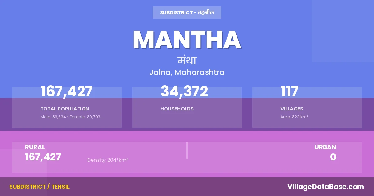
District → Jalna
State → Maharashtra
Mantha is a town and Tehsil in the Jalna district of the Maharashtra. In India, a Tehsil is a subdivision of a district responsible for the administration and revenue collection of a specific area within the district. Tehsils play a crucial role in the local governance structure, contributing significantly to the development and administration of their communities.
According to the 2011 census The total area of Mantha Tehsil is 823 km², with a population of 167427 people. The population density is 204 inhabitants per square kilometre, and there are approximately 34372 houses in the sub district.
Mantha Tehsil comprises about 117 villages. Below is a list of these villages along with information about their respective gram panchayats and the nearest town:
| # | Village Name | Gram Panchayat | Nearest Town |
|---|---|---|---|
| 1 | Akani | Akani | Partur (22 km) |
| 2 | Ambhoda Kadam | Ambhoda Kadam | Partur (42 km) |
| 3 | Ambhor Shelke | Ambhora Shelke | Partur (50 km) |
| 4 | Ambhora Jahagir | Ambhora Jahangir | Partur (37 km) |
| 5 | Andhwadi | Andhawadi | Lonar (20 km) |
| 6 | Arda Khari | Ardakhari | Sailu (23 km) |
| 7 | Arda Tolaji | Arda Tolaji | Partur (25 km) |
| 8 | Awalgaon | Hatwan | Partur (30 km) |
| 9 | Barbada | Barbadaa | Partur (25 km) |
| 10 | Belora | Belora | Partur (53 km) |
| 11 | Bhuwan | Wazar Sarkate | Jalna (72 km) |
| 12 | Bramhnath Tanda | Partur (25 km) | |
| 13 | Chandeshwar | Vidolli Kh | Sailu (25 km) |
| 14 | Chikhali | Hanwat Kheda | Partur (60 km) |
| 15 | Daha | Daha | Partur (55 km) |
| 16 | Dahifal Khandare | Dahiphal Khandare | Partur (35 km) |
| 17 | Deogaon Khawate | Deogaon Khavne | Lonar (20 km) |
| 18 | Devthana Mantha | Deothana Mantha | Partur (30 km) |
| 19 | Devthana Uswad | Deothana Uswad | Lonar (15 km) |
| 20 | Dhoksal | Dhoksal | Partur (20 km) |
| 21 | Dhonde Pimpalgaon | Dhondi Pimpalgaon | Jalna (40 km) |
| 22 | Dudha | Dudha | Lonar (18 km) |
| 23 | Erandeshwar | Yerandeshwar | Partur (50 km) |
| 24 | Ganeshpur | Ambhora Jahangir | Partur (30 km) |
| 25 | Garteki Tanda | Garteki Tanda | Partur (55 km) |
| 26 | Georai | Georai | Partur (4 km) |
| 27 | Gopegaon | Hatwan | Mantha |
| 28 | Gulkhand | Gulkhand | Partur (25 km) |
| 29 | Gulkhand Tanda | Gulkhand Tanda | Partur (25 km) |
| 30 | Hanwat Kheda | Hanwat Kheda | Lonar (19 km) |
| 31 | Hatwan | Hatwan | Partur (23 km) |
| 32 | Helas | Helas | Partur (36 km) |
| 33 | Helaswadi | Helaswadi | Sailu (20 km) |
| 34 | Hiwarkheda | Hiwarkheda | Partur (29 km) |
| 35 | Incha | Incha | Lonar (18 km) |
| 36 | Jaipur | Jaipur | Partur (55 km) |
| 37 | Jambharun | Jambharun | Lonar (21 km) |
| 38 | Jatkheda | Limbona | Partur (42 km) |
| 39 | Kanadi | Kanadi | Partur (22 km) |
| 40 | Kanphodi | Kathala Kh | Partur (18 km) |
| 41 | Karnawal | Karnawal | Partur (38 km) |
| 42 | Kathala Bk | Kathala Bk | Partur (25 km) |
| 43 | Kathala Kh | Kathala Kh | Partur (25 km) |
| 44 | Kedarwakadi | Kedar Wakadi | Partur (25 km) |
| 45 | Kehalwadgaon | Kehal Wadgaon | Lonar (16 km) |
| 46 | Kendhali | Kendhali | Partur (22 km) |
| 47 | Khari Arda | Ardakhari | Sailu (20 km) |
| 48 | Khorad Sawangi | Khorad Sawangi | Partur (48 km) |
| 49 | Khorwad | Khorwad | Partur (59 km) |
| 50 | Kinkheda | Pangra Gadade | Partur (52 km) |
| 51 | Kirla | Kirla | Lonar (21 km) |
| 52 | Kirtapur | Kirtapur | Partur (55 km) |
| 53 | Kirtapur Tanda | Kirtapur | Partur (30 km) |
| 54 | Kokarasa | Yerandeshwar | Partur (40 km) |
| 55 | Kokramba | Kokaramba | Lonar (18 km) |
| 56 | Lawni | Lavani | Partur (21 km) |
| 57 | Limbewadgaon | Limbewadgaon | Sailu (25 km) |
| 58 | Limbkheda | Limbkheda | Lonar (18 km) |
| 59 | Limbona | Limbona | Partur (30 km) |
| 60 | Mahora | Mahora | Partur (36 km) |
| 61 | Malegaon | Malegaon | Partur (28 km) |
| 62 | Malkini | Malkani | Partur (40 km) |
| 63 | Malsawangi | Peva | Partur (50 km) |
| 64 | Maltondi | Maltondi | Partur (43 km) |
| 65 | Mangrul | Mangrul | Partur (30 km) |
| 66 | Mantha | Mantha | Partur (30 km) |
| 67 | Meskheda | Meskheda | Partur (40 km) |
| 68 | Mohdari | Khorwad | Partur (50 km) |
| 69 | Mosa | Gulkhand Tanda | Jalna (40 km) |
| 70 | Murumkheda | Taltondi | Partur (37 km) |
| 71 | Naigaon P Bamhani | Naigaon | Partur (55 km) |
| 72 | Naigaon P Sevli | Naigaon | Mantha |
| 73 | Nansi | Nansi | Partur (23 km) |
| 74 | Padlidudha | Padali Dudha | Partur (50 km) |
| 75 | Pakni | Pakani | Partur (17 km) |
| 76 | Palaskheda | Shivangari | Mantha |
| 77 | Pandhurna | Wadhegaon | Partur (43 km) |
| 78 | Pangra Gadadhe | Pangra Gadade | Partur (55 km) |
| 79 | Pangri | Pangri Gosavi | Partur (25 km) |
| 80 | Pangri Bk | Pangari Bk | Partur (42 km) |
| 81 | Pangri Kh | Panghri Kh | Partur (39 km) |
| 82 | Patoda Bk | Patoda Bk | Sailu (20 km) |
| 83 | Patoda Kh | Patoda Bk | Sailu (20 km) |
| 84 | Pewa | Peva | Partur (48 km) |
| 85 | Pimparkheda Kharabe | Pimparkheda Kharabe | Partur (45 km) |
| 86 | Pokhai Kandhali | Pokhari Kendhale | Partur (85 km) |
| 87 | Pokhari Takle | Pokharitakale | Partur (35 km) |
| 88 | Ramtirth | Ramtirtha | Partur (37 km) |
| 89 | Ranmala | Ranmala | Sailu (24 km) |
| 90 | Saskheda | Dudha | Lonar (19 km) |
| 91 | Sawargaon Wayal | Sawargaon Wayal | Partur (45 km) |
| 92 | Shivangiri | Shivangari | Partur (35 km) |
| 93 | Sirpur | Sirpur | Lonar (18 km) |
| 94 | Sonunkarwadi | Sonunkarwadi | Partur (47 km) |
| 95 | Takalkhopa | Takalkhopa | Lonar (20 km) |
| 96 | Talegaon | Talegaon | Partur (35 km) |
| 97 | Talni | Talni | Lonar (13 km) |
| 98 | Taltondi | Taltondi | Partur (39 km) |
| 99 | Thengewadgaon | Thengewadgaon | Partur (25 km) |
| 100 | Tokwadi | Tokwadi | Partur (33 km) |
| 101 | Tupa | Jambharun | Partur (75 km) |
| 102 | Umarkheda | Umarkheda | Partur (35 km) |
| 103 | Uswad | Uswad | Lonar (17 km) |
| 104 | Vaidhywadgaon | Vaidya Wadgaon | Partur (25 km) |
| 105 | Vidoli Bk | Vidoli Bk | Partur (38 km) |
| 106 | Vidoli Kh | Vidolli Kh | Partur (25 km) |
| 107 | Wadgaon Sarhadu | Wadgaon Sarhad | Lonar (9 km) |
| 108 | Wadhegaon | Wadhegaon | Partur (20 km) |
| 109 | Waghala | Waghala | Partur (53 km) |
| 110 | Waghoda | Waghoda | Partur (20 km) |
| 111 | Waghoda Tanda | Waghoda Tanda | Partur (25 km) |
| 112 | Wai | Wai | Jalna (40 km) |
| 113 | Wanjola | Wanjola | Partur (6 km) |
| 114 | Warud | Waghoda | Partur (36 km) |
| 115 | Watur Tanda | Watur Tanda | Partur (18 km) |
| 116 | Wazar Sarkate | Wazar Sarkate | Partur (90 km) |
| 117 | Wirgavhan | Virgavan | Partur (41 km) |
The population is distributed between urban and rural areas as follows:
| Particulars | Rural | Urban | Total |
|---|---|---|---|
| Total Population | 167427 | 0 | 167427 |
| Male Population | 86634 | 0 | 86634 |
| Female Population | 80793 | 0 | 80793 | Population Density | 204 / km² | 204 / km² |
The distribution of households in the Mantha is:
| Rural Households | Urban Households | Total Households |
|---|---|---|
| 34372 | 0 | 34372 |
Q: What is Mantha?
A: Mantha is a town and in the Jalna district of the Maharashtra.
Q: What is the total area of Mantha Tehsil?
A: The total area of Mantha Tehsil is 823 km².
Q: What is the population of Mantha Tehsil according to the 2011 census?
A: According to the 2011 census, the population of Mantha Tehsil is 167427.
Q: What is the population density of Mantha Tehsil?
A: The population density of Mantha Tehsil is 204 inhabitants per square kilometre.
Q: How many houses are there in Mantha Tehsil?
A: There are approximately 34372 houses in Mantha Tehsil.
Q: How many villages are there in Mantha Tehsil?
A: There are about 117 villages in Mantha Tehsil.
Q: Which is the largest village by population in Mantha Tehsil?
A: The largest village by population in Mantha Tehsil is Mantha, with 22005 people.
Q: Which is the smallest village by population in Mantha Tehsil?
A: The smallest village by population in Mantha Tehsil is Gopegaon, with 0 people.
Q: Which is the largest village by area in Mantha Tehsil?
A: The largest village by area in Mantha Tehsil is Talni, with 2363 km².
Q: Which is the smallest village by area in Mantha Tehsil?
A: The smallest village by area in Mantha Tehsil is Garteki Tanda, with 0 km².
Q: What is the population distribution between urban and rural areas in Mantha Tehsil?
A: The population distribution in Mantha Tehsil is entirely rural, with a total rural population of 167427.
Q: What is the male population of Mantha Tehsil?
A: The male population of Mantha Tehsil is 86634.
Q: What is the female population of Mantha Tehsil?
A: The female population of Mantha Tehsil is 80793.
Q: How is the household distribution in Mantha Tehsil?
A: The household distribution in Mantha Tehsil is entirely rural, with a total of 34372 households.
Q: How many villages in Mantha Tehsil have a population of less than 100?
A: There are 5 villages in Mantha Tehsil with a population of less than 100.
Q: How many villages in Mantha Tehsil have a population between 100 and 499?
A: There are 16 villages in Mantha Tehsil with a population between 100 and 499.
Q: How many villages in Mantha Tehsil have a population between 500 and 999?
A: There are 32 villages in Mantha Tehsil with a population between 500 and 999.
Q: How many villages in Mantha Tehsil have a population between 1000 and 1999?
A: There are 42 villages in Mantha Tehsil with a population between 1000 and 1999.
Q: How many villages in Mantha Tehsil have a population between 2000 and 2999?
A: There is 15 village in Mantha Tehsil with a population between 2000 and 2999.
Q: How many villages in Mantha Tehsil have a population between 3000 and 3999?
A: There is 4 village in Mantha Tehsil with a population between 3000 and 3999.
Q: How many villages in Mantha Tehsil have a population between 4000 and 4999?
A: There is 1 village in Mantha Tehsil with a population between 4000 and 4999.
Q: How many villages in Mantha Tehsil have a population of 5000 and above?
A: There is 2 village in Mantha Tehsil with a population of 5000 and above.
| Total Population | Villages in Sub District Of Mantha |
|---|---|
| Less than 100 | 5 |
| 100-499 | 16 |
| 500-999 | 32 |
| 1000-1999 | 42 |
| 2000-2999 | 15 |
| 3000-3999 | 4 |
| 4000-4999 | 1 |
| 5000 And Above | 2 |