District → Satara
State → Maharashtra
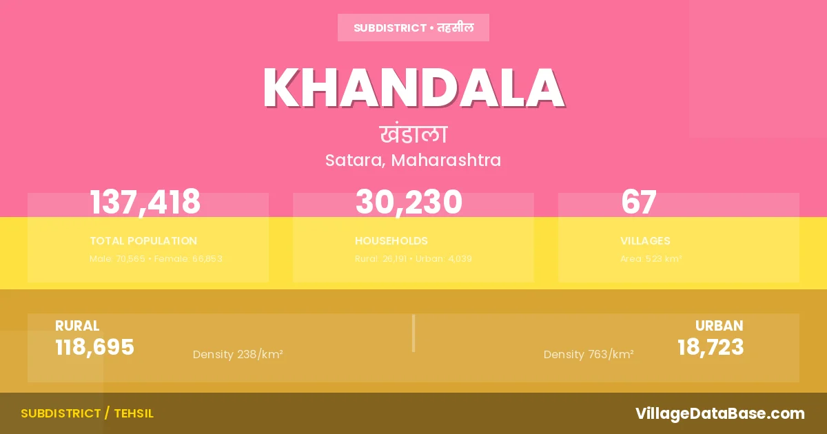
Khandala is a town and Tehsil in the Satara district of the Maharashtra. In India, a Tehsil is a subdivision of a district responsible for the administration and revenue collection of a specific area within the district. Tehsils play a crucial role in the local governance structure, contributing significantly to the development and administration of their communities.
According to the 2011 census The total area of Khandala Tehsil is 523 km², with a population of 137418 people. The population density is 263 inhabitants per square kilometre, and there are approximately 30230 houses in the sub district.
Khandala Tehsil comprises about 67 villages. Below is a list of these villages along with information about their respective gram panchayats and the nearest town:
| # | Village Name | Gram Panchayat | Nearest Town |
|---|---|---|---|
| 1 | Ahire | Ahire | Wai (35 km) |
| 2 | Ajnuj | Ajnuj | Wai (32 km) |
| 3 | Ambarwadi | Ambarwadi | Wai (35 km) |
| 4 | Andori | Andori | Phaltan (37 km) |
| 5 | Asawali | Asawali | Wai (35 km) |
| 6 | Atit | Atit | Bhor (15 km) |
| 7 | Balu Patlachiwadi | Balu Patalachiwadi | Phaltan (32 km) |
| 8 | Bavda | Bavada | Wai (32 km) |
| 9 | Bavkalwadi | Bavakalwadi | Phaltan (39 km) |
| 10 | Bhadavade | Bhadavade | Wai (35 km) |
| 11 | Bhade | Bhade | Phaltan (56 km) |
| 12 | Bhatghar | Bhatghar | Bhor (2 km) |
| 13 | Bholi | Bholi | Wai (35 km) |
| 14 | Bori | Bori | Phaltan (30 km) |
| 15 | Dhangarwadi | Dhanagarwadi | Bhor (16 km) |
| 16 | Dhawadwadi | Dhavadwadi | Wai (33 km) |
| 17 | Ghadgewadi | Ghadagewadi | Bhor (25 km) |
| 18 | Ghatdare | Ghatdare | Wai (33 km) |
| 19 | Guthalwadi | Guthalwadi | Bhor (8 km) |
| 20 | Harali | Harali | Wai (33 km) |
| 21 | Hartali | Rajewadi | Bhor (5 km) |
| 22 | Javale | Javale | Wai (48 km) |
| 23 | Kanhavadi | Kanhavadi | Bhor (5 km) |
| 24 | Kanheri | Kanheri | Wai (40 km) |
| 25 | Karadwadi | Karadwadi | Phaltan (37 km) |
| 26 | Karnavadi | Karnvadi | Bhor (22 km) |
| 27 | Kavathe | Kavathe | Wai (46 km) |
| 28 | Kesurdi | Kesurdi | Wai (26 km) |
| 29 | Khandala | Khandala | Wai (30 km) |
| 30 | Khed Bk | Khed Bk | Phaltan (34 km) |
| 31 | Koparde | Koparde | Phaltan (12 km) |
| 32 | Limachiwadi | Limbachiwadi | Bhor (27 km) |
| 33 | Lohom | Lohom | Bhor (25 km) |
| 34 | Lonand | Lonand | Khandala |
| 35 | Loni | Loni | Bhor (35 km) |
| 36 | Mane Colony | Bholi | Wai (40 km) |
| 37 | Mariachiwadi | Mariaichiwadi | Phaltan (32 km) |
| 38 | Mhavashi | Mhavashi | Wai (30 km) |
| 39 | Mirje | Miraje | Bhor (25 km) |
| 40 | Moh Tarf Shirwal | Shirwal | Khandala |
| 41 | Morve | Morve | Wai (35 km) |
| 42 | Naigaon | Naigaon | Bhor (26 km) |
| 43 | Nimbodi | Nimbodi | Phaltan (36 km) |
| 44 | Padali | Padali | Phaltan (37 km) |
| 45 | Padegaon | Padegaon | Phaltan (38 km) |
| 46 | Palashi | Palashi | Bhor (15 km) |
| 47 | Pargaon | Pargaon | Wai (20 km) |
| 48 | Pimpare Bk | Pimpare Bk | Phaltan (43 km) |
| 49 | Pisalwadi | Pisalwadi | Bhor (16 km) |
| 50 | Rajewadi | Rajewadi | Bhor (5 km) |
| 51 | Rui | Andori | Phaltan (38 km) |
| 52 | Sangvi | Sangavi | Bhor (25 km) |
| 53 | Shedgewadi | Shedagewadi | Phaltan (44 km) |
| 54 | Shekhmirwadi | Shekhmirwadi | Wai (26 km) |
| 55 | Shindewadi | Shindewadi | Bhor (17 km) |
| 56 | Shirwal | Shirwal | Bhor (17 km) |
| 57 | Shivajinagar | Shivajinagar | Wai (35 km) |
| 58 | Sukhed | Sukhed | Phaltan (36 km) |
| 59 | Tondal | Tondal | Bhor (30 km) |
| 60 | Vadgaon | Wadgaon | Bhor (27 km) |
| 61 | Wadwadi | Rajewadi | Bhor (5 km) |
| 62 | Waghoshi | Waghoshi | Phaltan (37 km) |
| 63 | Wanyachiwadi | Wanechiwadi | Wai (28 km) |
| 64 | Wathar Bk | Wathar Bk | Phaltan (44 km) |
| 65 | Wing | Wing | Bhor (7 km) |
| 66 | Yelewadi | Bori | Phaltan (33 km) |
| 67 | Zagalwadi | Zagalwadi | Bhor (25 km) |
The population is distributed between urban and rural areas as follows:
| Particulars | Rural | Urban | Total |
|---|---|---|---|
| Total Population | 118695 | 18723 | 137418 |
| Male Population | 61005 | 9560 | 70565 |
| Female Population | 57690 | 9163 | 66853 | Population Density | 238 / km² | 763 / km² | 263 / km² |
The distribution of households in the Khandala is:
| Rural Households | Urban Households | Total Households |
|---|---|---|
| 26191 | 4039 | 30230 |
Q: What is Khandala?
A: Khandala is a town and in the Satara district of the Maharashtra.
Q: What is the total area of Khandala Tehsil?
A: The total area of Khandala Tehsil is 523 km².
Q: What is the population of Khandala Tehsil according to the 2011 census?
A: According to the 2011 census, the population of Khandala Tehsil is 137418.
Q: What is the population density of Khandala Tehsil?
A: The population density of Khandala Tehsil is 263 inhabitants per square kilometre.
Q: How many houses are there in Khandala Tehsil?
A: There are approximately 30230 houses in Khandala Tehsil.
Q: How many villages are there in Khandala Tehsil?
A: There are about 67 villages in Khandala Tehsil.
Q: Which is the largest village by population in Khandala Tehsil?
A: The largest village by population in Khandala Tehsil is Shirwal, with 16080 people.
Q: Which is the smallest village by population in Khandala Tehsil?
A: The smallest village by population in Khandala Tehsil is Lonand, with 0 people.
Q: Which is the largest village by area in Khandala Tehsil?
A: The largest village by area in Khandala Tehsil is Khed Bk, with 2318 km².
Q: Which is the smallest village by area in Khandala Tehsil?
A: The smallest village by area in Khandala Tehsil is Lonand, with 0 km².
Q: What is the male population of Khandala Tehsil?
A: The male population of Khandala Tehsil is 70565.
Q: What is the female population of Khandala Tehsil?
A: The female population of Khandala Tehsil is 66853.
Q: How many villages in Khandala Tehsil have a population of less than 100?
A: There are 2 villages in Khandala Tehsil with a population of less than 100.
Q: How many villages in Khandala Tehsil have a population between 100 and 499?
A: There are 6 villages in Khandala Tehsil with a population between 100 and 499.
Q: How many villages in Khandala Tehsil have a population between 500 and 999?
A: There are 17 villages in Khandala Tehsil with a population between 500 and 999.
Q: How many villages in Khandala Tehsil have a population between 1000 and 1999?
A: There are 22 villages in Khandala Tehsil with a population between 1000 and 1999.
Q: How many villages in Khandala Tehsil have a population between 2000 and 2999?
A: There is 14 village in Khandala Tehsil with a population between 2000 and 2999.
Q: How many villages in Khandala Tehsil have a population between 3000 and 3999?
A: There is 4 village in Khandala Tehsil with a population between 3000 and 3999.
Q: How many villages in Khandala Tehsil have a population of 5000 and above?
A: There is 2 village in Khandala Tehsil with a population of 5000 and above.
| Total Population | Villages in Sub District Of Khandala |
|---|---|
| Less than 100 | 2 |
| 100-499 | 6 |
| 500-999 | 17 |
| 1000-1999 | 22 |
| 2000-2999 | 14 |
| 3000-3999 | 4 |
| 5000 And Above | 2 |