Tengnoupal: A Town and Subdivision in Chandel district
District → Chandel
State → Manipur
Tengnoupal is a town and Subdivision in the Chandel district of the Manipur. In India, a Subdivision is a subdivision of a district responsible for the administration and revenue collection of a specific area within the district. Subdivisions play a crucial role in the local governance structure, contributing significantly to the development and administration of their communities.
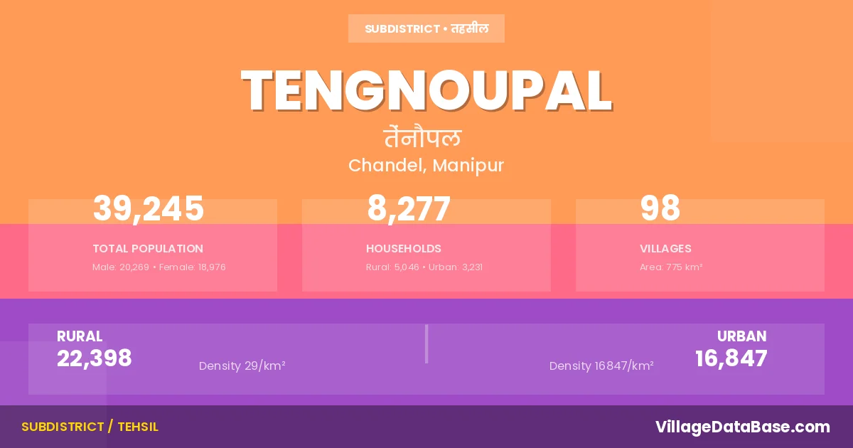
According to the 2011 census The total area of Tengnoupal Subdivision is 775 km², with a population of 39245 people. The population density is 51 inhabitants per square kilometre, and there are approximately 8277 houses in the sub district.
Tengnoupal Subdivision comprises about 98 villages. Below is a list of these villages along with information about their respective gram panchayats and the nearest town:
| # | Village Name | Gram Panchayat | Nearest Town |
|---|---|---|---|
| 1 | A Chandonpokpi | Kakching Mci (12 km) | |
| 2 | A Chingnunghut | Kakching Mci (12 km) | |
| 3 | A Khudamphai | Kakching Mci (18 km) | |
| 4 | A Khullen | Kakching Mci (12 km) | |
| 5 | A Khunjai | Kakching Mci (12 km) | |
| 6 | A Kombirei | Kakching Mci (12 km) | |
| 7 | A Ngairong | Kakching Mci (12 km) | |
| 8 | A Saitu | Kakching Mci (17 km) | |
| 9 | A Tampak | Kakching Mci (18 km) | |
| 10 | Aigijang | Kakching Mci (30 km) | |
| 11 | Angbrasu | Moreh Stc (15 km) | |
| 12 | B Bongjang | Moreh (20 km) | |
| 13 | B Sangreng | Tengnoupal | |
| 14 | Beauralam | Kakching Mci (20 km) | |
| 15 | C Gamnom | Kakching Mci (16 km) | |
| 16 | Chahmol | Kakching (37 km) | |
| 17 | Chalson Tengnoupal | Moreh Stc (2 km) | |
| 18 | Chehlep | Kakching Mci (48 km) | |
| 19 | Chikim | Tengnoupal | |
| 20 | Choktong | Moreh (25 km) | |
| 21 | Chonjang | Moreh (35 km) | |
| 22 | D Monaphai | Moreh (2 km) | |
| 23 | Damjol | Kakching Mci (14 km) | |
| 24 | Govajang | Moreh (15 km) | |
| 25 | H Kotlenphai | Kakching Mci (20 km) | |
| 26 | H Mongjang | Moreh (12 km) | |
| 27 | H Wajang | Kakching Mci (24 km) | |
| 28 | Island | Kakching Mci (12 km) | |
| 29 | K Moulshang | Moreh (2 km) | |
| 30 | K Zalenmoul | Moreh (9 km) | |
| 31 | Kambang Khullen | Moreh (47 km) | |
| 32 | Kambang Khunou | Kakching (25 km) | |
| 33 | Kanankhuren | Kakching Mci (18 km) | |
| 34 | Khaosat | Kakching (10 km) | |
| 35 | Kharou Khullen | Moreh (15 km) | |
| 36 | Kharou Khunou | Moreh (40 km) | |
| 37 | Khongkhang | Moreh (10 km) | |
| 38 | Khonomphai | Moreh (1 km) | |
| 39 | Khudei Khullen | Moreh Stc (20 km) | |
| 40 | Khudei Laipham | Moreh Stc (35 km) | |
| 41 | Kwatha | Moreh (16 km) | |
| 42 | L Phaijang | Kakching Mci (15 km) | |
| 43 | L Phunchong | Moreh (3 km) | |
| 44 | L Sijang | Kakching Mci (43 km) | |
| 45 | Lamjangtombi | Kakching (32 km) | |
| 46 | Lamlong Khunou | Moreh Stc (30 km) | |
| 47 | Langkhongching | Kakching (48 km) | |
| 48 | Leibi | Moreh (25 km) | |
| 49 | Leisan Tengnoupal | Moreh Stc (20 km) | |
| 50 | Leitan | Kakching (52 km) | |
| 51 | Loikong | Moreh (49 km) | |
| 52 | Maipi Mangsom | Moreh Stc (7 km) | |
| 53 | Mankang Khunthak | Tengnoupal | |
| 54 | Maojang | Moreh Stc (18 km) | |
| 55 | Modenphai | Kakching Mci (30 km) | |
| 56 | Moirengthel | Moreh (24 km) | |
| 57 | Molnoi | Kakching Mci (7 km) | |
| 58 | Molnom | Kakching Mci (18 km) | |
| 59 | Moyon Khullen | Moreh Stc (18 km) | |
| 60 | N Champhai | Moreh (7 km) | |
| 61 | Narum | Kakching (43 km) | |
| 62 | New Leikot | Moreh (3 km) | |
| 63 | New Mongjang | Moreh (31 km) | |
| 64 | New Shijang | Moreh (3 km) | |
| 65 | Phaichambung | Kakching Mci (20 km) | |
| 66 | Phalbung | Kakching (28 km) | |
| 67 | Rilam Centre | Moreh (45 km) | |
| 68 | Ringkhudam | Kakching Mci (18 km) | |
| 69 | S D Munjang | Kakching Mci (20 km) | |
| 70 | S Khudengthabi | Moreh (12 km) | |
| 71 | S M Lhangjol | Moreh Stc (28 km) | |
| 72 | S Moljol | Moreh (4 km) | |
| 73 | S P Saichang | Kakching Mci (15 km) | |
| 74 | Saibol | Kakching (39 km) | |
| 75 | Sairel Saisem | Moreh (25 km) | |
| 76 | Saivom | Kakching (35 km) | |
| 77 | Satang | Moreh (44 km) | |
| 78 | Senam | Kakching Mci (30 km) | |
| 79 | Sita | Moreh Stc (42 km) | |
| 80 | T Khonomjang | Moreh Stc (35 km) | |
| 81 | T Maipi | Moreh Stc (7 km) | |
| 82 | T Minou | Tengnoupal | |
| 83 | T Yangom | Moreh (18 km) | |
| 84 | Tatjang | Moreh (5 km) | |
| 85 | Tengnoupal | Kakching Mci (35 km) | |
| 86 | Teraphai | Kakching Mci (12 km) | |
| 87 | Theimungkung | Kakching Mci (12 km) | |
| 88 | Tinnu Munjang | Moreh (2 km) | |
| 89 | Touthang Bongmol | Moreh (30 km) | |
| 90 | Tuipi Mate | Moreh (20 km) | |
| 91 | Tuisomjang | Kakching Mci (24 km) | |
| 92 | Wakshu | Moreh (30 km) | |
| 93 | Yangoubung | Moreh (32 km) | |
| 94 | Yangoupokpi | Moreh (3 km) | |
| 95 | Yangoutubi | Moreh (4 km) | |
| 96 | Youjang | Tengnoupal | |
| 97 | Youngkhul | Moreh (18 km) | |
| 98 | Zion | Kakching Mci (13 km) |
The population is distributed between urban and rural areas as follows:
| Particulars | Rural | Urban | Total |
|---|---|---|---|
| Total Population | 22398 | 16847 | 39245 |
| Male Population | 11599 | 8670 | 20269 |
| Female Population | 10799 | 8177 | 18976 | Population Density | 29 / km² | 16847 / km² | 51 / km² |
The distribution of households in the Tengnoupal is:
| Rural Households | Urban Households | Total Households |
|---|---|---|
| 5046 | 3231 | 8277 |
Q: What is Tengnoupal?
A: Tengnoupal is a town and in the Chandel district of the Manipur.
Q: What is the total area of Tengnoupal Subdivision?
A: The total area of Tengnoupal Subdivision is 775 km².
Q: What is the population of Tengnoupal Subdivision according to the 2011 census?
A: According to the 2011 census, the population of Tengnoupal Subdivision is 39245.
Q: What is the population density of Tengnoupal Subdivision?
A: The population density of Tengnoupal Subdivision is 51 inhabitants per square kilometre.
Q: How many houses are there in Tengnoupal Subdivision?
A: There are approximately 8277 houses in Tengnoupal Subdivision.
Q: How many villages are there in Tengnoupal Subdivision?
A: There are about 98 villages in Tengnoupal Subdivision.
Q: Which is the largest village by population in Tengnoupal Subdivision?
A: The largest village by population in Tengnoupal Subdivision is Tengnoupal, with 2158 people.
Q: Which is the smallest village by population in Tengnoupal Subdivision?
A: The smallest village by population in Tengnoupal Subdivision is B Sangreng, with 0 people.
Q: Which is the largest village by area in Tengnoupal Subdivision?
A: The largest village by area in Tengnoupal Subdivision is A Chandonpokpi, with 0 km².
Q: Which is the smallest village by area in Tengnoupal Subdivision?
A: The smallest village by area in Tengnoupal Subdivision is A Chandonpokpi, with 0 km².
Q: What is the male population of Tengnoupal Subdivision?
A: The male population of Tengnoupal Subdivision is 20269.
Q: What is the female population of Tengnoupal Subdivision?
A: The female population of Tengnoupal Subdivision is 18976.
Q: How many villages in Tengnoupal Subdivision have a population of less than 100?
A: There are 18 villages in Tengnoupal Subdivision with a population of less than 100.
Q: How many villages in Tengnoupal Subdivision have a population between 100 and 499?
A: There are 77 villages in Tengnoupal Subdivision with a population between 100 and 499.
Q: How many villages in Tengnoupal Subdivision have a population between 500 and 999?
A: There are 2 villages in Tengnoupal Subdivision with a population between 500 and 999.
Q: How many villages in Tengnoupal Subdivision have a population between 2000 and 2999?
A: There is 1 village in Tengnoupal Subdivision with a population between 2000 and 2999.
| Total Population | Villages in Sub District Of Tengnoupal |
|---|---|
| Less than 100 | 18 |
| 100-499 | 77 |
| 500-999 | 2 |
| 2000-2999 | 1 |