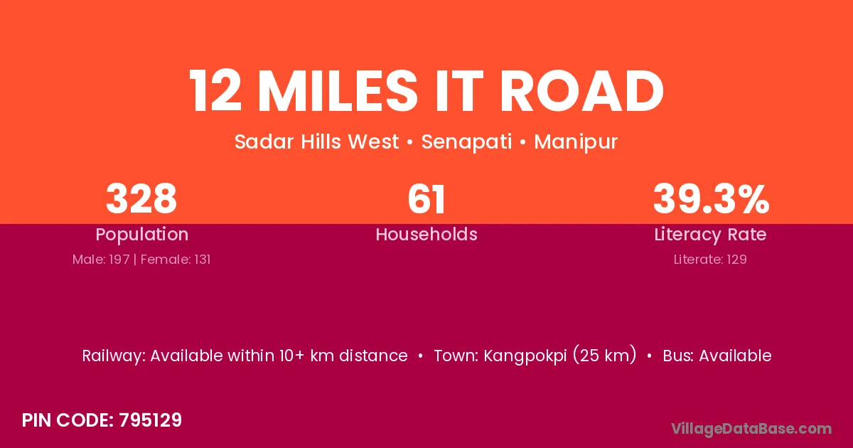
12 Miles It Road village is located in the Sadar Hills West Subdivision of the Senapati district in Manipur .
Block / Subdivision → Sadar Hills West
District → Senapati
State → Manipur
According to Census 2011 information, the village code of 12 Miles It Road village is 795129.
12 Miles It Road village has a total population of 328 people, of which 197 are males and 131 are females.
The literacy rate of 12 Miles It Road village is 39.33%. Male literacy stands at 47.72% and female literacy at 26.72%.
There are approximately 61 households in 12 Miles It Road village.
Kangpokpi (25 km) is the nearest town to 12 Miles It Road village for major economic activities and is located approximately 25 km away.
The population of 12 Miles It Road village is distributed between literate and illiterate residents as follows:
| Particulars | Male | Female | Total |
|---|---|---|---|
| Literate | 94 | 35 | 129 |
| Illiterate | 103 | 96 | 199 |
| Total | 197 | 131 | 328 |
Source: Census 2011
| Village | District |
|---|---|
| Geljang | Senapati |
| Holjang | Senapati |
| Khollen | Senapati |
| Khommunom | Senapati |
| Kotlen | Senapati |
| Kotlen | Senapati |
| Leisang | Churachandpur |
| Leisang | Senapati |
| Paodel Basti | Senapati |
| Selsi | Senapati |
| Songjang Pakang | Senapati |
| Songjang Phailen | Senapati |
| Songpijang | Senapati |
No reviews yet. Be the first to review this village!
Available within 10+ km distance
Available within 10+ km distance
Available within 10+ km distance