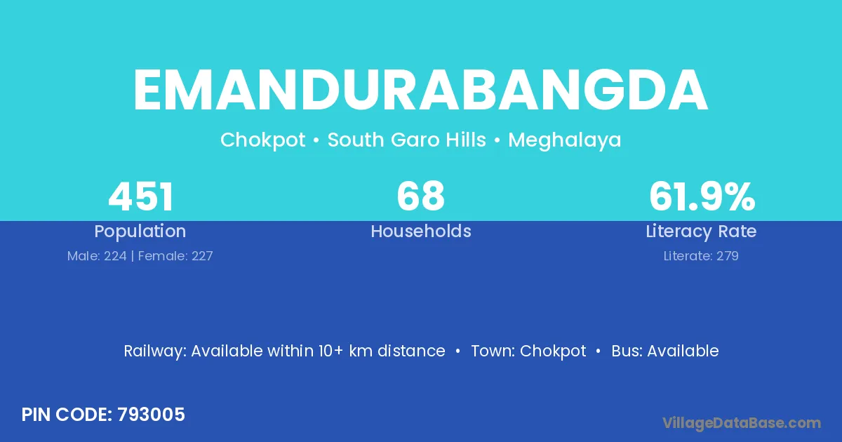
Emandurabangda village is located in the Chokpot Subdivision of the South Garo Hills district in Meghalaya .
Block / Subdivision → Chokpot
District → South Garo Hills
State → Meghalaya
According to Census 2011 information, the village code of Emandurabangda village is 793005.
Emandurabangda village has a total population of 451 people, of which 224 are males and 227 are females.
The literacy rate of Emandurabangda village is 61.86%. Male literacy stands at 67.41% and female literacy at 56.39%.
There are approximately 68 households in Emandurabangda village.
Chokpot is the nearest town to Emandurabangda village for major economic activities
The population of Emandurabangda village is distributed between literate and illiterate residents as follows:
| Particulars | Male | Female | Total |
|---|---|---|---|
| Literate | 151 | 128 | 279 |
| Illiterate | 73 | 99 | 172 |
| Total | 224 | 227 | 451 |
Source: Census 2011
| Village | District |
|---|---|
| Dabolgre | South Garo Hills |
| Darengiri | South Garo Hills |
| Dobagiri | South Garo Hills |
| Gopgiri | South Garo Hills |
| Kakijagiri | South Garo Hills |
| Paromgre | South Garo Hills |
| Redingsi Songgital | South Garo Hills |
| Rongma Paromgiri | South Garo Hills |
| Rongma Rekmangiri | South Garo Hills |
| Sembu Rongtolgittim | South Garo Hills |
| Tokrok Anchenggre | South Garo Hills |
No reviews yet. Be the first to review this village!
Available within 10+ km distance
Available within 10+ km distance
Available within 10+ km distance