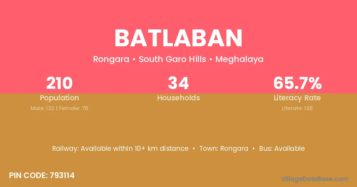
Batlaban village is located in the Rongara Subdivision of the South Garo Hills district in Meghalaya .
Block / Subdivision → Rongara
District → South Garo Hills
State → Meghalaya
According to Census 2011 information, the village code of Batlaban village is 793114.
Batlaban village has a total population of 210 people, of which 132 are males and 78 are females.
The literacy rate of Batlaban village is 65.71%. Male literacy stands at 65.15% and female literacy at 66.67%.
There are approximately 34 households in Batlaban village.
Rongara is the nearest town to Batlaban village for major economic activities
The population of Batlaban village is distributed between literate and illiterate residents as follows:
| Particulars | Male | Female | Total |
|---|---|---|---|
| Literate | 86 | 52 | 138 |
| Illiterate | 46 | 26 | 72 |
| Total | 132 | 78 | 210 |
Source: Census 2011
| Village | District |
|---|---|
| Adachepa | South Garo Hills |
| Ailatuli | South Garo Hills |
| Betgora | South Garo Hills |
| Bonberra | South Garo Hills |
| Dulbeta | South Garo Hills |
| Hatibel | South Garo Hills |
| Kanai | Bhojpur |
| Kanai | Bilaspur |
| Kanai | Janjgir Champa |
| Kanai | Sabar Kantha |
| Kanai | Surat |
| Kanai | Balaghat |
| Kanai | Singrauli |
| Kanai | South Garo Hills |
| Kanai | Viluppuram |
| Mohadeo Warima | South Garo Hills |
| Nikwatgre | East Garo Hills |
| Nikwatgre | South Garo Hills |
| Upper Pasgao | South Garo Hills |
| Warima Konagittim | South Garo Hills |
No reviews yet. Be the first to review this village!
Available within 10+ km distance
Available within 10+ km distance
Available within 10+ km distance