Chawngte: A Town and Subdivision in Lawngtlai district
District → Lawngtlai
State → Mizoram
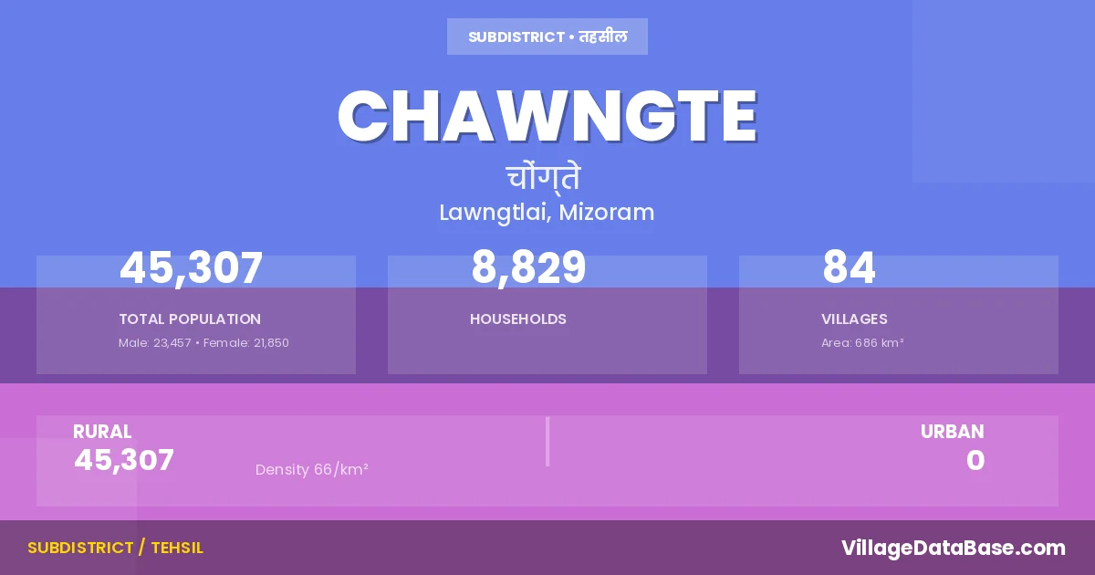
Chawngte is a town and Subdivision in the Lawngtlai district of the Mizoram. In India, a Subdivision is a subdivision of a district responsible for the administration and revenue collection of a specific area within the district. Subdivisions play a crucial role in the local governance structure, contributing significantly to the development and administration of their communities.
According to the 2011 census The total area of Chawngte Subdivision is 686 km², with a population of 45307 people. The population density is 66 inhabitants per square kilometre, and there are approximately 8829 houses in the sub district.
Chawngte Subdivision comprises about 84 villages. Below is a list of these villages along with information about their respective gram panchayats and the nearest town:
| # | Village Name | Gram Panchayat | Nearest Town |
|---|---|---|---|
| 1 | Adubangasora | Chawngte (24 km) | |
| 2 | Ajasora | Lawngtlai (31 km) | |
| 3 | Ajasora Ii | Lawngtlai (36 km) | |
| 4 | Ajasora Iii | Lawngtlai (33 km) | |
| 5 | Bajeisora | Chawngte (9 km) | |
| 6 | Betbonya | Lawngtlai (30 km) | |
| 7 | Bilosora | Chawngte (36 km) | |
| 8 | Boganpara | Chawngte (8 km) | |
| 9 | Bondukbangsora | Chawngte (50 km) | |
| 10 | Boraguisuri | Chawngte (27 km) | |
| 11 | Boraituli | Lawngtlai (54 km) | |
| 12 | Borakabakhali | Chawngte (35 km) | |
| 13 | Borapansury I | Lawngtlai (52 km) | |
| 14 | Borapansury Ii | Lunglei (35 km) | |
| 15 | Borkolok | Lawngtlai (33 km) | |
| 16 | Bormon | Lawngtlai | |
| 17 | Boronasury | Lawwngtlai (42 km) | |
| 18 | Bortuli | Chawngte (42 km) | |
| 19 | Bungkawn S | Chawngte (26 km) | |
| 20 | Chaminisora | Chawngte (45 km) | |
| 21 | Charluitlang | Chawngte (47 km) | |
| 22 | Chhippui | Chawngte (42 km) | |
| 23 | Chhotaguisuri I | Chawngte (55 km) | |
| 24 | Chhotaguisuri Ii | Chawngte (40 km) | |
| 25 | Chhotapansury | Chawngte (48 km) | |
| 26 | Damdep I | Chawngte (30 km) | |
| 27 | Damdep Ii | Chawngte (34 km) | |
| 28 | Devasora | Chawngte (35 km) | |
| 29 | Devasora S | Chawngte (30 km) | |
| 30 | Duduksora | Lawngtlai | |
| 31 | Dursora | Chawngte (24 km) | |
| 32 | Futsora | Chawngte (40 km) | |
| 33 | Futsury | Chawngte (50 km) | |
| 34 | Geraguluksora | Chawngte (35 km) | |
| 35 | Gerasury | Chawngte (55 km) | |
| 36 | Gobabsuri | Chawngte (39 km) | |
| 37 | Golasuri | :lawngtlai (31 km) | |
| 38 | Gulsingbabsora | Chawngte (12 km) | |
| 39 | Jamersury | Chawngte (10 km) | |
| 40 | Jaruldulbasora | Chawngte (52 km) | |
| 41 | Jarulsury | Chawngte (18 km) | |
| 42 | Kamalanagar Iv | Lawngtlai (42 km) | |
| 43 | Kamlanagar I | Chawngte (8 km) | |
| 44 | Kamlanagar Ii | Chawngte (10 km) | |
| 45 | Kamlanagar Iii | Chawngte (9 km) | |
| 46 | Kamtuli | Lawngltai (42 km) | |
| 47 | Kukurduleya | Chawngte (27 km) | |
| 48 | Kurbalavasora | Lawngtlai (46 km) | |
| 49 | Lokhisuri | Chawngte (45 km) | |
| 50 | Longpuighat | Chawngte (31 km) | |
| 51 | Ludisora | Lawngtlai (50 km) | |
| 52 | Mainababsora I | Chawngte (35 km) | |
| 53 | Mainababsora Ii | Chawngte (40 km) | |
| 54 | Mandirasora | Chawngte (16 km) | |
| 55 | Montola | Chawngte (19 km) | |
| 56 | Nagdarasora | Chawngte (29 km) | |
| 57 | Nalbanya | Chawngte (7 km) | |
| 58 | New Chhippui | Chawngte (45 km) | |
| 59 | Ngharum | Chawngte (15 km) | |
| 60 | Old Bajeisora | Chawngte (35 km) | |
| 61 | Pablakhali | Chawngte (55 km) | |
| 62 | Parva I | Chawngte (20 km) | |
| 63 | Parva Ii | Chawngte (35 km) | |
| 64 | Parva Iii | Lawngtlai (40 km) | |
| 65 | Peglababsora | Chawngte (37 km) | |
| 66 | Rajmandal I | Lawngtlai | |
| 67 | Rajmandal Ii | Lawngtlai (54 km) | |
| 68 | Rengashya | Chawngte (20 km) | |
| 69 | Silbanga | Chawngte (40 km) | |
| 70 | Silosora | Chawngte (30 km) | |
| 71 | Silsury | Chawngte (45 km) | |
| 72 | Simeinasora | Chawngte (52 km) | |
| 73 | Simeisuri | Lawngtlai (34 km) | |
| 74 | Songrasury | Chawngte (54 km) | |
| 75 | Tongasora | Chawngte (47 km) | |
| 76 | Udalthana I | Chawngte (3 km) | |
| 77 | Udalthana Ii | Chawngte (42 km) | |
| 78 | Ugudasury | Chawngte (27 km) | |
| 79 | Ugudasury S | Chawngte (20 km) | |
| 80 | Ugulsury | Chawngte (38 km) | |
| 81 | Ulusury | Chawngte (20 km) | |
| 82 | Vaseitlang I | Lawngtlai (37 km) | |
| 83 | Vaseitlang Ii | Lawngtlai (32 km) | |
| 84 | W Saizawh | Chawngte (4 km) |
The population is distributed between urban and rural areas as follows:
| Particulars | Rural | Urban | Total |
|---|---|---|---|
| Total Population | 45307 | 0 | 45307 |
| Male Population | 23457 | 0 | 23457 |
| Female Population | 21850 | 0 | 21850 | Population Density | 66 / km² | 66 / km² |
The distribution of households in the Chawngte is:
| Rural Households | Urban Households | Total Households |
|---|---|---|
| 8829 | 0 | 8829 |
Q: What is Chawngte?
A: Chawngte is a town and in the Lawngtlai district of the Mizoram.
Q: What is the total area of Chawngte Subdivision?
A: The total area of Chawngte Subdivision is 686 km².
Q: What is the population of Chawngte Subdivision according to the 2011 census?
A: According to the 2011 census, the population of Chawngte Subdivision is 45307.
Q: What is the population density of Chawngte Subdivision?
A: The population density of Chawngte Subdivision is 66 inhabitants per square kilometre.
Q: How many houses are there in Chawngte Subdivision?
A: There are approximately 8829 houses in Chawngte Subdivision.
Q: How many villages are there in Chawngte Subdivision?
A: There are about 84 villages in Chawngte Subdivision.
Q: Which is the largest village by population in Chawngte Subdivision?
A: The largest village by population in Chawngte Subdivision is Kamlanagar Ii, with 2714 people.
Q: Which is the smallest village by population in Chawngte Subdivision?
A: The smallest village by population in Chawngte Subdivision is Bormon, with 0 people.
Q: Which is the largest village by area in Chawngte Subdivision?
A: The largest village by area in Chawngte Subdivision is Adubangasora, with 0 km².
Q: Which is the smallest village by area in Chawngte Subdivision?
A: The smallest village by area in Chawngte Subdivision is Adubangasora, with 0 km².
Q: What is the population distribution between urban and rural areas in Chawngte Subdivision?
A: The population distribution in Chawngte Subdivision is entirely rural, with a total rural population of 45307.
Q: What is the male population of Chawngte Subdivision?
A: The male population of Chawngte Subdivision is 23457.
Q: What is the female population of Chawngte Subdivision?
A: The female population of Chawngte Subdivision is 21850.
Q: How is the household distribution in Chawngte Subdivision?
A: The household distribution in Chawngte Subdivision is entirely rural, with a total of 8829 households.
Q: How many villages in Chawngte Subdivision have a population of less than 100?
A: There are 5 villages in Chawngte Subdivision with a population of less than 100.
Q: How many villages in Chawngte Subdivision have a population between 100 and 499?
A: There are 46 villages in Chawngte Subdivision with a population between 100 and 499.
Q: How many villages in Chawngte Subdivision have a population between 500 and 999?
A: There are 24 villages in Chawngte Subdivision with a population between 500 and 999.
Q: How many villages in Chawngte Subdivision have a population between 1000 and 1999?
A: There are 7 villages in Chawngte Subdivision with a population between 1000 and 1999.
Q: How many villages in Chawngte Subdivision have a population between 2000 and 2999?
A: There is 2 village in Chawngte Subdivision with a population between 2000 and 2999.
| Total Population | Villages in Sub District Of Chawngte |
|---|---|
| Less than 100 | 5 |
| 100-499 | 46 |
| 500-999 | 24 |
| 1000-1999 | 7 |
| 2000-2999 | 2 |