District → Peren
State → Nagaland
Athibung is a town and Circle in the Peren district of the Nagaland. In India, a Circle is a subdivision of a district responsible for the administration and revenue collection of a specific area within the district. Circles play a crucial role in the local governance structure, contributing significantly to the development and administration of their communities.
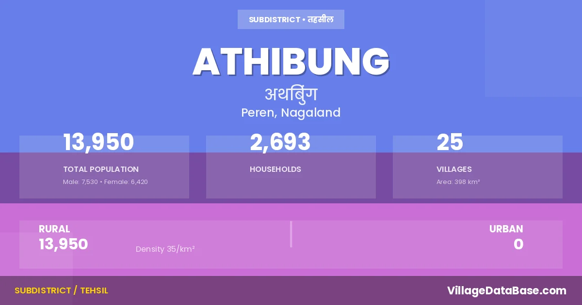
According to the 2011 census The total area of Athibung Circle is 398 km², with a population of 13950 people. The population density is 35 inhabitants per square kilometre, and there are approximately 2693 houses in the sub district.
Athibung Circle comprises about 25 villages. Below is a list of these villages along with information about their respective gram panchayats and the nearest town:
| # | Village Name | Gram Panchayat | Nearest Town |
|---|---|---|---|
| 1 | Athibung | Jalukie Town (18 km) | |
| 2 | Beisumpuikam | Jalukie Town (44 km) | |
| 3 | Bongkolong | Jalukie Town (31 km) | |
| 4 | Bunglen | Jalukie Town (3 km) | |
| 5 | Gellhang | Jalukie (50 km) | |
| 6 | Gopibung | Jalukie Town (45 km) | |
| 7 | Inbung | Jalukie Town (19 km) | |
| 8 | Lilen | Jalukie Town (12 km) | |
| 9 | Lilen B | Jalukie (5 km) | |
| 10 | Mouicham | Jalukie Town (3 km) | |
| 11 | New Beisumpui | Jalukie Town (30 km) | |
| 12 | New Chalkot | Jalukie Town (10 km) | |
| 13 | New Pellhang | Jalukie (3 km) | |
| 14 | Newchamcha | Jalukie Town (35 km) | |
| 15 | Old Beisumpui | Jalukie Town (35 km) | |
| 16 | Old Chalkot | Jalukie Town (16 km) | |
| 17 | Pellhang | Jalukie Town (50 km) | |
| 18 | Pellhang B | Jalukie (40 km) | |
| 19 | Phaijol | Jalukie Town (13 km) | |
| 20 | Phanjang | Jaluki (5 km) | |
| 21 | Saijang | Jalukie (6 km) | |
| 22 | Songlhuh | Jalukie Town (19 km) | |
| 23 | Songsang | Jalukie (28 km) | |
| 24 | Vongkithem | Jalukie Town (20 km) | |
| 25 | Vongkithem B | Jalukie Town (22 km) |
The population is distributed between urban and rural areas as follows:
| Particulars | Rural | Urban | Total |
|---|---|---|---|
| Total Population | 13950 | 0 | 13950 |
| Male Population | 7530 | 0 | 7530 |
| Female Population | 6420 | 0 | 6420 | Population Density | 35 / km² | 35 / km² |
The distribution of households in the Athibung is:
| Rural Households | Urban Households | Total Households |
|---|---|---|
| 2693 | 0 | 2693 |
Q: What is Athibung?
A: Athibung is a town and in the Peren district of the Nagaland.
Q: What is the total area of Athibung Circle?
A: The total area of Athibung Circle is 398 km².
Q: What is the population of Athibung Circle according to the 2011 census?
A: According to the 2011 census, the population of Athibung Circle is 13950.
Q: What is the population density of Athibung Circle?
A: The population density of Athibung Circle is 35 inhabitants per square kilometre.
Q: How many houses are there in Athibung Circle?
A: There are approximately 2693 houses in Athibung Circle.
Q: How many villages are there in Athibung Circle?
A: There are about 25 villages in Athibung Circle.
Q: Which is the largest village by population in Athibung Circle?
A: The largest village by population in Athibung Circle is Beisumpuikam, with 2904 people.
Q: Which is the smallest village by population in Athibung Circle?
A: The smallest village by population in Athibung Circle is Bunglen, with 0 people.
Q: Which is the largest village by area in Athibung Circle?
A: The largest village by area in Athibung Circle is Athibung, with 0 km².
Q: Which is the smallest village by area in Athibung Circle?
A: The smallest village by area in Athibung Circle is Athibung, with 0 km².
Q: What is the population distribution between urban and rural areas in Athibung Circle?
A: The population distribution in Athibung Circle is entirely rural, with a total rural population of 13950.
Q: What is the male population of Athibung Circle?
A: The male population of Athibung Circle is 7530.
Q: What is the female population of Athibung Circle?
A: The female population of Athibung Circle is 6420.
Q: How is the household distribution in Athibung Circle?
A: The household distribution in Athibung Circle is entirely rural, with a total of 2693 households.
Q: How many villages in Athibung Circle have a population of less than 100?
A: There are 9 villages in Athibung Circle with a population of less than 100.
Q: How many villages in Athibung Circle have a population between 100 and 499?
A: There are 7 villages in Athibung Circle with a population between 100 and 499.
Q: How many villages in Athibung Circle have a population between 500 and 999?
A: There are 6 villages in Athibung Circle with a population between 500 and 999.
Q: How many villages in Athibung Circle have a population between 2000 and 2999?
A: There is 3 village in Athibung Circle with a population between 2000 and 2999.
| Total Population | Villages in Sub District Of Athibung |
|---|---|
| Less than 100 | 9 |
| 100-499 | 7 |
| 500-999 | 6 |
| 2000-2999 | 3 |