Khuntuni: A Town and Tehsil in Cuttack district
District → Cuttack
State → Odisha
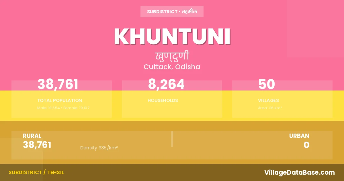
Khuntuni is a town and Tehsil in the Cuttack district of the Odisha. In India, a Tehsil is a subdivision of a district responsible for the administration and revenue collection of a specific area within the district. Tehsils play a crucial role in the local governance structure, contributing significantly to the development and administration of their communities.
According to the 2011 census The total area of Khuntuni Tehsil is 116 km², with a population of 38761 people. The population density is 335 inhabitants per square kilometre, and there are approximately 8264 houses in the sub district.
Khuntuni Tehsil comprises about 50 villages. Below is a list of these villages along with information about their respective gram panchayats and the nearest town:
| # | Village Name | Gram Panchayat | Nearest Town |
|---|---|---|---|
| 1 | Anantapur | Dhurusia | Athagad (20 km) |
| 2 | Baudhapur | Dhurusia | Athagad (14 km) |
| 3 | Belda | Radhakishorepur | Athagad (18 km) |
| 4 | Bhogara | Dalabhaga | Athagad (10 km) |
| 5 | Bhuinbarei | Dhurusia | Athagad (17 km) |
| 6 | Binjhagiri | Dhurusia | Athagad (16 km) |
| 7 | Brahmapur | Dhurusia | Athagad (17 km) |
| 8 | Champapur | Mahakalbasta | Athagad (8 km) |
| 9 | Champia | Dalabhaga | Athagad (12 km) |
| 10 | Chandrabalishyamapur | Ghantikhal | Athagad (13 km) |
| 11 | Chhenakhianuagan | Dalabhaga | Athagad (14 km) |
| 12 | Dalabhaga | Dalabhaga | Athagad (16 km) |
| 13 | Dalua | Kandarei | Athagad (16 km) |
| 14 | Dhurusia | Dhurusia | Athagad (16 km) |
| 15 | Ghantikhala | Ghantikhal | Athagad (13 km) |
| 16 | Gopalprasad | Dhurusia | Athagad (15 km) |
| 17 | Jagmohanpur | Dhurusia | Athagad (16 km) |
| 18 | Jenapur | Dhurusia | Athagad (15 km) |
| 19 | Kandarei | Kandarei | Athagad (17 km) |
| 20 | Kansar | Kandarei | Athagad (17 km) |
| 21 | Keutapada | Dhurusia | Athagad (16 km) |
| 22 | Khamarnuagan | Radhakishorepur | Athagad (18 km) |
| 23 | Khanduali | Kandarei | Athagad (19 km) |
| 24 | Khuntuni | Khuntuni | Athagad (13 km) |
| 25 | Krushnashyampur | Khuntuni | Athagad (12 km) |
| 26 | Machhapur | Radhakishorepur | Athagad (18 km) |
| 27 | Madhabpur | Mahakalbasta | Athagad (9 km) |
| 28 | Mahakalabasta | Mahakalbasta | Athagad (9 km) |
| 29 | Mahalaxmipur | Kandarei | Athagad (17 km) |
| 30 | Mantiri | Kandarei | Athagad (17 km) |
| 31 | Mathurapur | Kulailo | Athagad (10 km) |
| 32 | Nidhipur | Ghantikhal | Athagad (12 km) |
| 33 | Nuasasan | Dhurusia | Athagad (18 km) |
| 34 | Nursinghapur | Khuntuni | Athagad (17 km) |
| 35 | Purusottampur | Radhakishorepur | Athagad (18 km) |
| 36 | Radhadamodarpur | Radhakishorepur | Athagad (15 km) |
| 37 | Radhadhabpur | Mahakalbasta | Athagad (12 km) |
| 38 | Radhakishorpur | Radhakishorepur | Athagad (18 km) |
| 39 | Radhakrushnapur | Kandarei | Athagad (10 km) |
| 40 | Radhamadhabpur | Mahakalbasta | Athagad (8 km) |
| 41 | Radharamanpur | Khuntuni | Athagad (13 km) |
| 42 | Radhasaranpur | Kulailo | Athagad (10 km) |
| 43 | Radhashyampur | Ghantikhal | Athagad (16 km) |
| 44 | Rahangol | Kandarei | Athagad (18 km) |
| 45 | Rampei | Khuntuni | Athagad (13 km) |
| 46 | Ramshyampur | Ghantikhal | Athagad (18 km) |
| 47 | Sabitripur | Kandarei | Athagad (17 km) |
| 48 | Saraswatipur | Kandarei | Athagad (22 km) |
| 49 | Shrirangapur | Dhurusia | Athagad (17 km) |
| 50 | Totapada | Kulailo | Athagad (10 km) |
The population is distributed between urban and rural areas as follows:
| Particulars | Rural | Urban | Total |
|---|---|---|---|
| Total Population | 38761 | 0 | 38761 |
| Male Population | 19654 | 0 | 19654 |
| Female Population | 19107 | 0 | 19107 | Population Density | 335 / km² | 335 / km² |
The distribution of households in the Khuntuni is:
| Rural Households | Urban Households | Total Households |
|---|---|---|
| 8264 | 0 | 8264 |
Q: What is Khuntuni?
A: Khuntuni is a town and in the Cuttack district of the Odisha.
Q: What is the total area of Khuntuni Tehsil?
A: The total area of Khuntuni Tehsil is 116 km².
Q: What is the population of Khuntuni Tehsil according to the 2011 census?
A: According to the 2011 census, the population of Khuntuni Tehsil is 38761.
Q: What is the population density of Khuntuni Tehsil?
A: The population density of Khuntuni Tehsil is 335 inhabitants per square kilometre.
Q: How many houses are there in Khuntuni Tehsil?
A: There are approximately 8264 houses in Khuntuni Tehsil.
Q: How many villages are there in Khuntuni Tehsil?
A: There are about 50 villages in Khuntuni Tehsil.
Q: Which is the largest village by population in Khuntuni Tehsil?
A: The largest village by population in Khuntuni Tehsil is Rampei, with 3517 people.
Q: Which is the smallest village by population in Khuntuni Tehsil?
A: The smallest village by population in Khuntuni Tehsil is Binjhagiri, with 0 people.
Q: Which is the largest village by area in Khuntuni Tehsil?
A: The largest village by area in Khuntuni Tehsil is Radhakrushnapur, with 616 km².
Q: Which is the smallest village by area in Khuntuni Tehsil?
A: The smallest village by area in Khuntuni Tehsil is Shrirangapur, with 1 km².
Q: What is the population distribution between urban and rural areas in Khuntuni Tehsil?
A: The population distribution in Khuntuni Tehsil is entirely rural, with a total rural population of 38761.
Q: What is the male population of Khuntuni Tehsil?
A: The male population of Khuntuni Tehsil is 19654.
Q: What is the female population of Khuntuni Tehsil?
A: The female population of Khuntuni Tehsil is 19107.
Q: How is the household distribution in Khuntuni Tehsil?
A: The household distribution in Khuntuni Tehsil is entirely rural, with a total of 8264 households.
Q: How many villages in Khuntuni Tehsil have a population of less than 100?
A: There are 5 villages in Khuntuni Tehsil with a population of less than 100.
Q: How many villages in Khuntuni Tehsil have a population between 100 and 499?
A: There are 21 villages in Khuntuni Tehsil with a population between 100 and 499.
Q: How many villages in Khuntuni Tehsil have a population between 500 and 999?
A: There are 7 villages in Khuntuni Tehsil with a population between 500 and 999.
Q: How many villages in Khuntuni Tehsil have a population between 1000 and 1999?
A: There are 15 villages in Khuntuni Tehsil with a population between 1000 and 1999.
Q: How many villages in Khuntuni Tehsil have a population between 2000 and 2999?
A: There is 1 village in Khuntuni Tehsil with a population between 2000 and 2999.
Q: How many villages in Khuntuni Tehsil have a population between 3000 and 3999?
A: There is 1 village in Khuntuni Tehsil with a population between 3000 and 3999.
| Total Population | Villages in Sub District Of Khuntuni |
|---|---|
| Less than 100 | 5 |
| 100-499 | 21 |
| 500-999 | 7 |
| 1000-1999 | 15 |
| 2000-2999 | 1 |
| 3000-3999 | 1 |