Motunga: A Town and Tehsil in Dhenkanal district
District → Dhenkanal
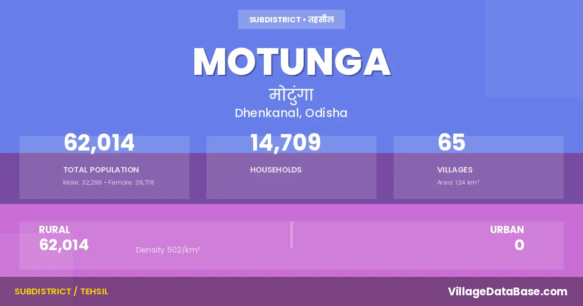
State → Odisha
Motunga is a town and Tehsil in the Dhenkanal district of the Odisha. In India, a Tehsil is a subdivision of a district responsible for the administration and revenue collection of a specific area within the district. Tehsils play a crucial role in the local governance structure, contributing significantly to the development and administration of their communities.
According to the 2011 census The total area of Motunga Tehsil is 124 km², with a population of 62014 people. The population density is 502 inhabitants per square kilometre, and there are approximately 14709 houses in the sub district.
Motunga Tehsil comprises about 65 villages. Below is a list of these villages along with information about their respective gram panchayats and the nearest town:
| # | Village Name | Gram Panchayat | Nearest Town |
|---|---|---|---|
| 1 | Artasantrakateni | Balaram Prasad | Dhenkanal (30 km) |
| 2 | Bachhuribanka | Bangurisingha | Dhenkanal (32 km) |
| 3 | Badalo | Badalo | Dhenkanal (37 km) |
| 4 | Balaramprasad | Balaram Prasad | Dhenkanal (25 km) |
| 5 | Bangurasinga | Bangurisingha | Dhenkanal (29 km) |
| 6 | Barabahali | Gunadei | Dhenkanal (26 km) |
| 7 | Barabahaljungle | Gunadei | Dhenkanal (26 km) |
| 8 | Bautiragada | Balaram Prasad | Dhenkanal (32 km) |
| 9 | Belapada | Gunadei | Dhenkanal (26 km) |
| 10 | Bido | Bido | Dhenkanal (27 km) |
| 11 | Binakarkateni | Naya Bhagirathipur | Dhenkanal (26 km) |
| 12 | Brajabiharipur | Naya Bhagirathipur | Dhenkanal (32 km) |
| 13 | Bramhanbasa | Naya Bhagirathipur | Dhenkanal (36 km) |
| 14 | Budhapanka | Bido | Anugul (28 km) |
| 15 | Budhipahad | Naya Bhagirathipur | Dhenkanal (26 km) |
| 16 | Charadagadia | Kharag Prasad | Dhenkanal (25 km) |
| 17 | Chheliabedha | Balaram Prasad | Dhenkanal (29 km) |
| 18 | Chintapokhari | Motanga | Dhenkanal (27 km) |
| 19 | Ekagharia | Bangurisingha | Dhenkanal (35 km) |
| 20 | Gailo | Gunadei | Dhenkanal (26 km) |
| 21 | Gaudapasi | Bido | Dhenkanal (25 km) |
| 22 | Ghantalapasi | Kharag Prasad | Dhenkanal (23 km) |
| 23 | Gharamapat | Naya Bhagirathipur | Dhenkanal (31 km) |
| 24 | Ghodadian | Badalo | Dhenkanal (35 km) |
| 25 | Gundei | Gunadei | Dhenkanal (26 km) |
| 26 | Gurumagadia | Kharag Prasad | Dhenkanal (23 km) |
| 27 | Haladibahali | Naya Bhagirathipur | Dhenkanal (33 km) |
| 28 | Handifuta | Badalo | Dhenkanal (35 km) |
| 29 | Jarada | Bangurisingha | Dhenkanal (29 km) |
| 30 | Kaikateni | Odapada | Dhenkanal (24 km) |
| 31 | Kalusahukateni | Naya Bhagirathipur | Dhenkanal (29 km) |
| 32 | Kangeilupal | Kharag Prasad | Dhenkanal (24 km) |
| 33 | Kharagprasad | Kharag Prasad | Dhenkanal (27 km) |
| 34 | Kharagprasadpatna | Kharag Prasad | Dhenkanal (27 km) |
| 35 | Kochilamada | Kharag Prasad | Dhenkanal (27 km) |
| 36 | Kunjabiharipur | Naya Bhagirathipur | Dhenkanal (31 km) |
| 37 | Kurunti | Kusupanga | Dhenkanal (26 km) |
| 38 | Kusupanga | Kusupanga | Dhenkanal (27 km) |
| 39 | Malibido | Bido | Dhenkanal (27 km) |
| 40 | Meramandali | Motanga | Dhenkanal (28 km) |
| 41 | Mohadia | Gunadei | Dhenkanal (26 km) |
| 42 | Motunga | Motanga | Dhenkanal (23 km) |
| 43 | Murdangapali | Balaram Prasad | Dhenkanal (32 km) |
| 44 | Nadhara | Nadhara | Anugul (31 km) |
| 45 | Nagari | Motanga | Dhenkanal (25 km) |
| 46 | Naraharipur | Badalo | Dhenkanal (34 km) |
| 47 | Nayabhagirathipur | Naya Bhagirathipur | Dhenkanal (31 km) |
| 48 | Nimidha | Nimidiha | Dhenkanal (33 km) |
| 49 | Nuara | Balaram Prasad | Dhenkanal (29 km) |
| 50 | Odapada | Odapada | Dhenkanal (27 km) |
| 51 | Paneilo | Bangurisingha | Dhenkanal (29 km) |
| 52 | Purunadiha | Naya Bhagirathipur | Dhenkanal (32 km) |
| 53 | Rangathali | Motanga | Dhenkanal (25 km) |
| 54 | Ranibania | Nimidiha | Dhenkanal (32 km) |
| 55 | Ranjasinga | Motanga | Dhenkanal (28 km) |
| 56 | Ratnapravapodapada | Odapada | Dhenkanal (33 km) |
| 57 | Salapada | Naya Bhagirathipur | Dhenkanal (33 km) |
| 58 | Sridihi | Badalo | Dhenkanal (32 km) |
| 59 | Suravi | Motanga | Anugul (24 km) |
| 60 | Talabaghalunda | Nadhara | Dhenkanal (31 km) |
| 61 | Taladanga | Motanga | Dhenkanal (27 km) |
| 62 | Tulasidihi | Kharag Prasad | Dhenkanal (23 km) |
| 63 | Uparbaghalunda | Nadhara | Dhenkanal (31 km) |
| 64 | Uperpal | Bido | Dhenkanal (26 km) |
| 65 | Zukateni | Balaram Prasad | Dhenkanal (25 km) |
The population is distributed between urban and rural areas as follows:
| Particulars | Rural | Urban | Total |
|---|---|---|---|
| Total Population | 62014 | 0 | 62014 |
| Male Population | 32296 | 0 | 32296 |
| Female Population | 29718 | 0 | 29718 | Population Density | 502 / km² | 502 / km² |
The distribution of households in the Motunga is:
| Rural Households | Urban Households | Total Households |
|---|---|---|
| 14709 | 0 | 14709 |
Q: What is Motunga?
A: Motunga is a town and in the Dhenkanal district of the Odisha.
Q: What is the total area of Motunga Tehsil?
A: The total area of Motunga Tehsil is 124 km².
Q: What is the population of Motunga Tehsil according to the 2011 census?
A: According to the 2011 census, the population of Motunga Tehsil is 62014.
Q: What is the population density of Motunga Tehsil?
A: The population density of Motunga Tehsil is 502 inhabitants per square kilometre.
Q: How many houses are there in Motunga Tehsil?
A: There are approximately 14709 houses in Motunga Tehsil.
Q: How many villages are there in Motunga Tehsil?
A: There are about 65 villages in Motunga Tehsil.
Q: Which is the largest village by population in Motunga Tehsil?
A: The largest village by population in Motunga Tehsil is Kharagprasad, with 4507 people.
Q: Which is the smallest village by population in Motunga Tehsil?
A: The smallest village by population in Motunga Tehsil is Barabahali, with 0 people.
Q: Which is the largest village by area in Motunga Tehsil?
A: The largest village by area in Motunga Tehsil is Kharagprasad, with 1313 km².
Q: Which is the smallest village by area in Motunga Tehsil?
A: The smallest village by area in Motunga Tehsil is Nadhara, with 6 km².
Q: What is the population distribution between urban and rural areas in Motunga Tehsil?
A: The population distribution in Motunga Tehsil is entirely rural, with a total rural population of 62014.
Q: What is the male population of Motunga Tehsil?
A: The male population of Motunga Tehsil is 32296.
Q: What is the female population of Motunga Tehsil?
A: The female population of Motunga Tehsil is 29718.
Q: How is the household distribution in Motunga Tehsil?
A: The household distribution in Motunga Tehsil is entirely rural, with a total of 14709 households.
Q: How many villages in Motunga Tehsil have a population of less than 100?
A: There are 14 villages in Motunga Tehsil with a population of less than 100.
Q: How many villages in Motunga Tehsil have a population between 100 and 499?
A: There are 10 villages in Motunga Tehsil with a population between 100 and 499.
Q: How many villages in Motunga Tehsil have a population between 500 and 999?
A: There are 18 villages in Motunga Tehsil with a population between 500 and 999.
Q: How many villages in Motunga Tehsil have a population between 1000 and 1999?
A: There are 17 villages in Motunga Tehsil with a population between 1000 and 1999.
Q: How many villages in Motunga Tehsil have a population between 2000 and 2999?
A: There is 3 village in Motunga Tehsil with a population between 2000 and 2999.
Q: How many villages in Motunga Tehsil have a population between 3000 and 3999?
A: There is 2 village in Motunga Tehsil with a population between 3000 and 3999.
Q: How many villages in Motunga Tehsil have a population between 4000 and 4999?
A: There is 1 village in Motunga Tehsil with a population between 4000 and 4999.
| Total Population | Villages in Sub District Of Motunga |
|---|---|
| Less than 100 | 14 |
| 100-499 | 10 |
| 500-999 | 18 |
| 1000-1999 | 17 |
| 2000-2999 | 3 |
| 3000-3999 | 2 |
| 4000-4999 | 1 |